Description
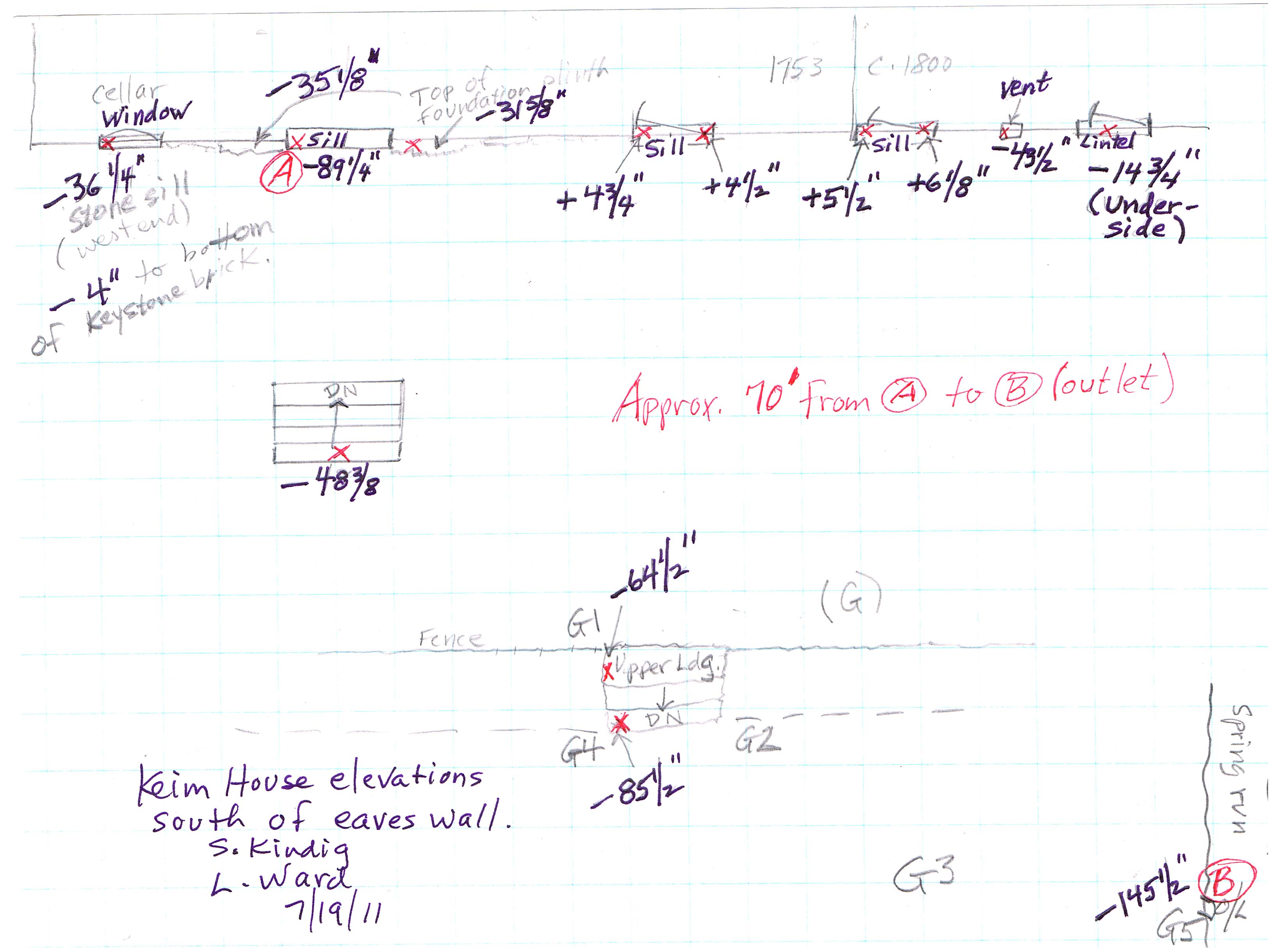
Keim House, field notes drawing, elevations South of the Southern eaves wall (2011). Digital image #1 is a Field Notes drawing showing the Keim House grade elevations south of the south eaves wall.
Description:
The data recorded on this sketch [together with future archaeological investigations] will provide guidance for determining the early and restored objective grades of the terraced yard area bounded by the 1753 house, the c.1800 addition, the mid-18th century "ancillary" wood-turner's shop building, and the low stone retaining wall separating the yard from the grass area north of the barn. The resulting data, in conjunction with soils strata and the degree of their disturbance, will possibly aid in determining the relative pre-and post-construction grades and the existence or non-existence of masonry supports for early entry structures at the 1753 and federal-era doorways. No such foundation remnants have been discovered as of 2015. This information will also facilitate the planning for surface drainage to be controlled by the final slopes, swales, and contours established for the terraced ground area and the contiguous inclined grade to the barn. Under early tradition and Common Law, these living and work areas adjacent to the house and principal dependency buildings have been called the "curtilage", and have been endowed with a privacy aspect for the occupants.
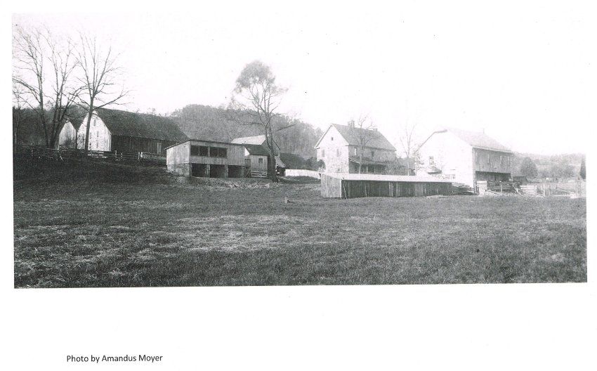
The wall and stone steps leading from the terrace to the barnyard were probably created in the 2d quarter of the 20th century (prior to the 1941 HABS photo in these archives), contemporaneously with construction of the two-wall porch that is depicted in archive record KHPH9--1002.01.044. Image #2, a photo taken c. 1929-1931 by Amandus D. Moyer, confirms the absence of a porch structure on the western gable wall as of the photo's date. The Moyer photo provides some indication of the early 20th century grades and slopes.
The early grade along the building is delineated by the top of the foundation plinth{1} which was concealed during the past century by the stone piers supporting the porches and the overfill of incoherent soils and small stones under the c.1930s porch (removed in 2011).
A stratum of dark top-soil a few feet below the present grade (which aligns with the top of the plinth) indicates that the post-construction (1753) grade was probably established by depositing sandy clay, probably excavated from the cellar space or from elsewhere on the farm, on top of the pre-construction topsoil.
The drawing in this record provides the plinth elevations on each side of the cellar entry opening [the east plinth is about 3.5 inches higher than the west]. These levels and the depth ["invert"] of the cellar doorway sill were the benchmarks which provided the relative elevations of the reconstructed stone retaining walls flanking the "cellarway" consisting of the stone steps and passage through the foundation wall [see record # KR11PH1].
The elevations recorded on the drawing and the point-to-point dimensions noted also indicate the appropriate pitch and run of the swales, contours, and topography of the surface drainage courses from the foundation, the roof runoff drip-line, and the perimeter-line of the retaining walls. All these grade contours are sloped toward the absorption area north of the barn and the margins of the spring-run south of the "ancillary" wood-turner's workshop building [see photos in record KR11PH2--1002.01.088]. These data could also provide a rational basis for future re-establishment of a close approximation of the grades south of the early farmstead buildings.
The elevation data also provided a mathematical framework for the constructive geometry and dimensions of the "cellar-cap" door and frame which would have spanned the retaining walls and sheltered the cellarway{2} passage; see archive record KR11PH1--1002.01.087 for commentary and photographs describing the reconstructed cellar entry-way, the probable form of early "cellar doors" [see the 1786 Rules of Work of the Carpenters' Company of the City and County of Philadelphia] which sheltered this opening, and the hypothesized "bulkhead" framing and sides ["cheek-walls"] which supported the angled and "hung-double" doors{3}.
The re-created retaining walls serve the dual functions of bearing the cellar doors and their support structure, and restraining the lateral soils and hydrostatic pressure from intruding into and jeopardizing the stairwell.
FOOTNOTES
{1} The base-wall ["footing", in modern terms; "basement" in neo-classical terminology] projecting beyond the plane of the wall it supports. This foundation segment, coarser in its irregular exterior plane than the "random rubble" contours of the above-grade walling, delineates the below-grade portion of the foundation. The plinth is thicker than the upper wall ranges, providing a structurally advantageous "basement" [the structural masonry perimeter supporting the building's superstructure and enclosing the cellar], and is not laid with a plumb face-plane or finish pointing, since it was not expected to be seen. It is quite possible that this segment of the foundation walls was laid from inside the cellar excavation, eliminating the need for pointing the exterior face of the plinth. The durability of the walling thus depended on "deep-pointing" the beds and joints from the interior of the cellar, rather than the more common practice of bedding and bonding ("mudding-in") the foundation stonework from both sides of the foundation, and often laying-up the exterior walls from a "builder's trench." Assuming that the base-stones are footed on a solid bearing sub-strate [on the Keim site, a dense amber-colored clay], both construction techniques provide a stable bearing system to carry the compressive load imposed by the massive super-structure of the masonry and timber-framed 1753 dwelling.
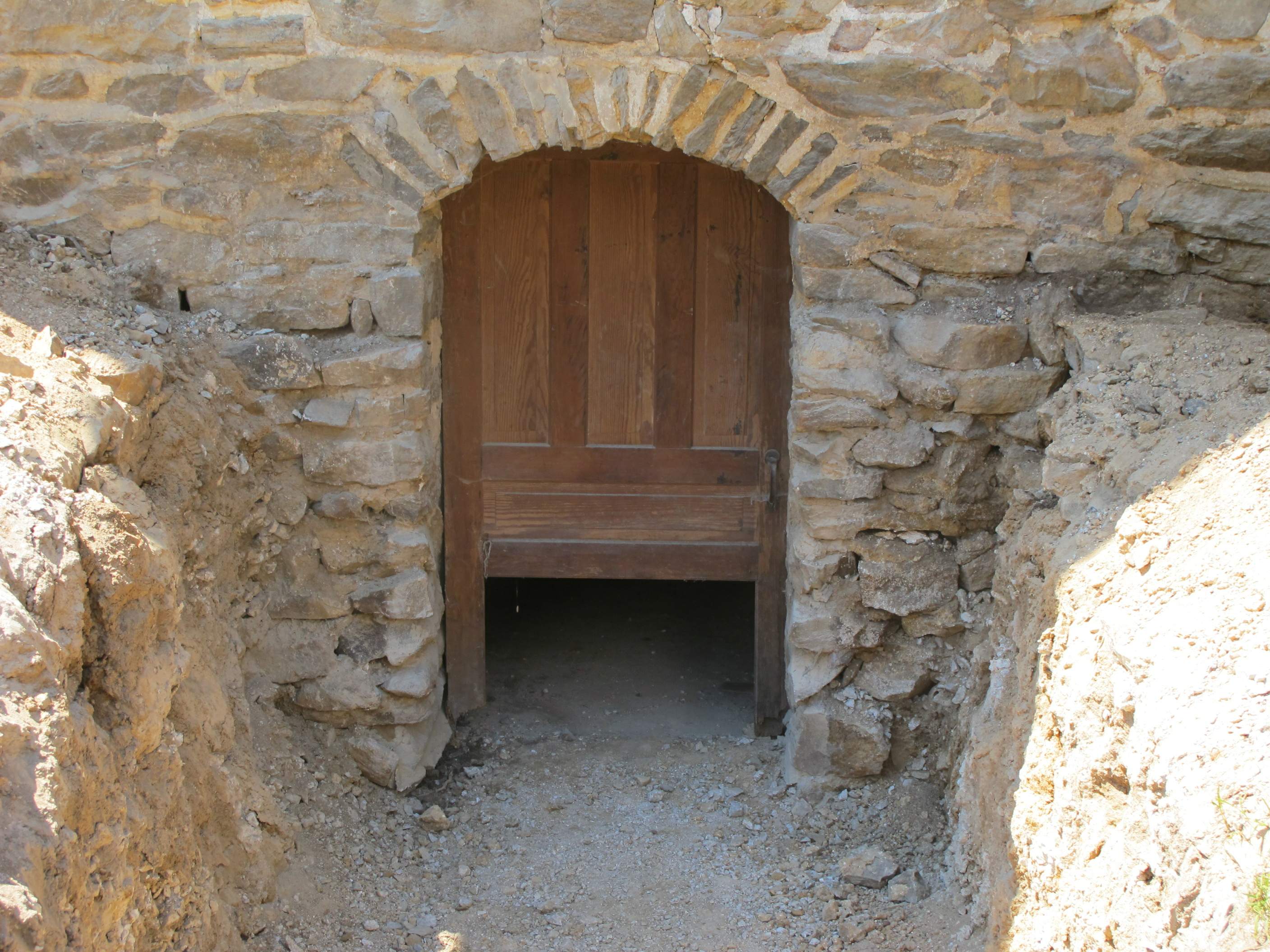
The top ["coping" or "water table"] of the plinth descends from west to east, delineating the final desired grade established as described above, and disappears as the grade along the wall falls toward the stone sill below the cellar doorway in the Federal-period addition. See the top of the "rubble" plinth in Image #3 [flanking the cellar doorway opening].
{2} Although a door could have been fastened to the interior abutments of the arched opening with pintles ["hooks", in 18th century terminology], no evidence has yet been found "documenting" a door frame attached to the arched masonry opening or joined to the joisted framing system above the cellar cavity enclosed by the basement. This suggests that no vertical door was present in the early period, which would further indicate the possibility of an "open-way" through the arched passage into the cellar. A door would obviously have provided a barrier of much smaller surface area than a "cellar cap" [the early term for the 19th-century "bulkhead" label] alone for the convection of heat out of the cellar in winter and into it in summer. A door and a cap would obviously provide a more effective thermal barrier than either alone.
{3} The raking bulkhead walls at the cellar entry on the northeast eaves wall of the c. 1762 White Horse Inn in Douglassville appear to be integrated with the foundation walls abutting the opening in a similar manner to the hypothesized bonded joint which probably originally tied the Keim cellarway retaining walls to the foundation plinth.
Laurence Ward, April, 2016 and updated January, 2021
Catalog details
- Catalog number
- 1002.01.085
- Alternate number
- KHFN2
- Accession number
- 1002.01
- Date
- 07/19/2011
- Creator
- Kindig, Stephen & Ward, Laurence
- Object name
- Field Notes
- Record type
- Archive
- Classification
- Documentary Artifact