Description
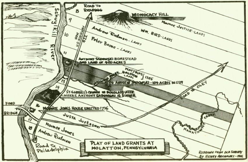
Map appearing in the booklet "Anthony Sadowski: Polish Pioneer" by Edward Pinkowski. Booklet was issued in connection with the dedication of the Anthony Sadowski historical marker in Douglassville, PA. Dedication ceremony for the marker occured on Sept. 18, 1966.
Map was drawn by Henry Archacki using old survey maps and shows early 18th-century land owners along the eastern bank of the Schuylkill River from Monocacy Hill to the north to the Mouns Jones tract to the south and east to Manatawny Creek. The long land parcels shown on Archaki's schematic map extended about two miles toward the northeast, with narrow frontage on the Schuylkill River. This tract configuration was consistent with William Penn's overture to "adventurers" [land purchasers]: "...every [purchaser] will have a considerable quantity of land....every one a proportion by a navigable river, and then backward into the country." [Some Account of the Province of Pennsylvania in America..., Section III, reprinted in Soderland, William Penn and the Founding of Pennsylvania, 1680-1684 at page 63.]
Entries in the Logan Account Books in the custody of The Historical Society of Pennsylvania record that Sadowski engaged in the "Indian Trade" in partnership[n] with his neighbor Mouns Jones. The journal entries detail transactions with both men in Indian trade goods, furs and "peltry", and general merchandise for immigrant settler's in Penn's neo-feudal "plantation." Some debit entries charge one with half of the cost of goods to the assumed share of the other.
[n] technically a "joint venture", since both men also traded on their individual accounts during the same time period.
Laurence Ward, June 2016
Catalog details
- Catalog number
- 1003.01.005
- Alternate number
- MVDWG1
- Accession number
- 1003.01
- Date
- 1966
- Creator
- Henry Archacki
- Object name
- Map
- Record type
- Archive
- Classification
- Documentary Artifact