![20: Exterior ["extrados"] of arched root cellar](https://ihfmesrtggjwnhkkettk.supabase.co/storage/v1/object/public/archive-public/hptbc/images/006/100301054-6.JPG)
![14, 10/19/16: Stone well and abutments [pump-platform base?] at grade](https://ihfmesrtggjwnhkkettk.supabase.co/storage/v1/object/public/archive-public/hptbc/images/006/100301054-5.JPG)
Description
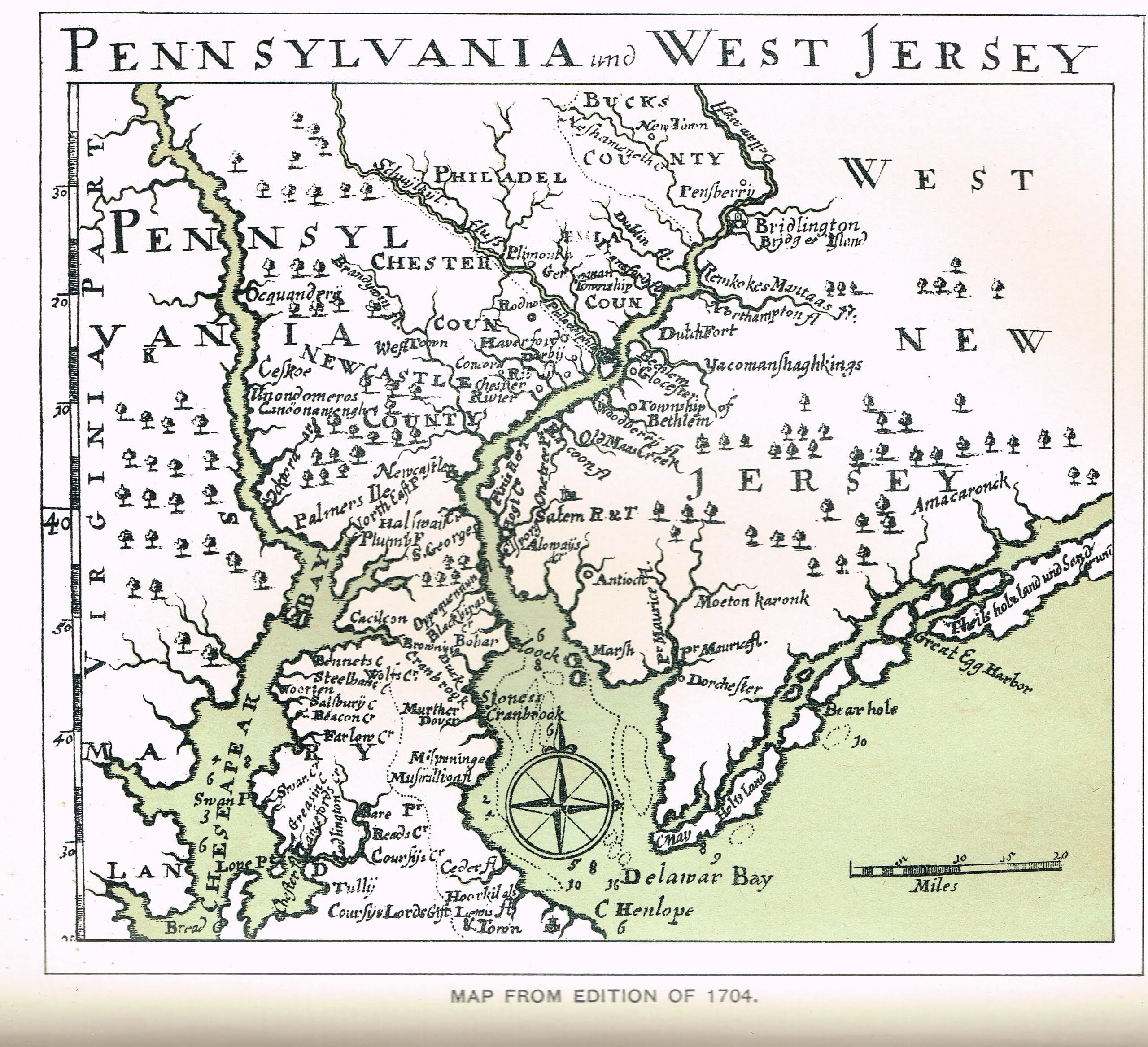
Series of seven images illustrating the variations in the place-names describing the area in which Mouns Jones settled in 1704 and which the Trust now calls Old Morlatton Village, situated between the Village of Douglassville and the Schuylkill River in southeastern Amity Township, Berks County, PA. More toponyms and variant spellings will be added to this record as sources are verified.
Daniel Falckner's 1704 map [Image #1] of Pennsylvania and West New Jersey records no place-names or identified waterways near the location of the embryonic Manatawny {a} settlement on the upper reaches of the Schuylkill River. Although a few tributaries are shown northwest of "Plimouth" in present-day lower Montgomery County, none are indicated for the confluences of the Manatawny, Monocacy, or French creeks with the River. Nor is there any cartographic notation of the presence of Mouns Jones, any of his family members, or his riverfront "plantation" within the blank frontier ["backcountry"] zone on Falckner's map.
Reverend Andreas Sandel's 1704 letter to his Lutheran superiors in Stockholm stated that "Mans" had "taken up residence" {b} in Manatawny by that time. However, Falckner's cartographer, probably working from slow-moving topographic and demographic information collected in the first few years of the 18th century, was apparently unaware of the presence of the first European settler on the banks of the Schuylkill River between the two tributaries defining the Manatawny region{c}.
Typically, the map also ignores the presence hundreds of First Native families and clan and community members hunting, fishing, and growing crops on their ancestral homeland along the Rive. During the first quarter of the 18th century, the Indians were trading with Mouns Jones, his immediate family, and his partner Anthony Sadowski, as well as with the French traders{d} Peter Bezaillion, James and Ann LeTour, Martin Chartiere and others engaged in the frontier river and creek valleys of southeastern Pennsylvania.
{d} After whom French Creek was named.
An extract from the "Reformed Church Record" of Jan. 24, 1907, published on page 134 of the "Pennsylvania German" magazine issued in March, 1907, records that in 1693 Swedish Lutheran church leaders in Pennsylvania petitioned officials in Sweden for two additional ministers for their flock. One of the appointees was Anders [sometimes "Andreas"] Rudman [e], who applied for and was granted 10,000 acres by William Penn in 1701, to be distributed among himself and his fellow Swedes who were willing to take up land in the remote region between the confluences of the Manatawny and "Manakesy" Creeks with the Schuylkill River. Mouns Jones was granted slightly less than 500 acres of this immense Penn grant in 1705, when he received his patent [essentially a Deed and confirmation of title], having "taken up" [occupied] the parcel in 1701 or 1702 and, by inference from Reverend Sandel's letter, having constructed his first dwelling there by 1704.
{e} Reverend Rudman's pastoral and diplomatic careers are detailed in "The Life and Influence of Andreas Rudman" by Ronald W. Oudinot in The Historical Review of Berks County, Volume XLIV, Number 2, Spring, 1979, starting at page 59.
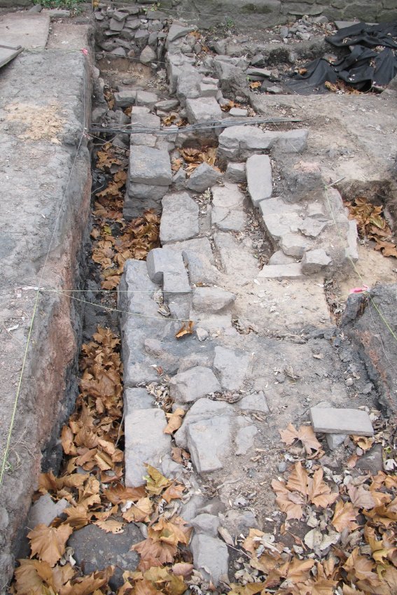
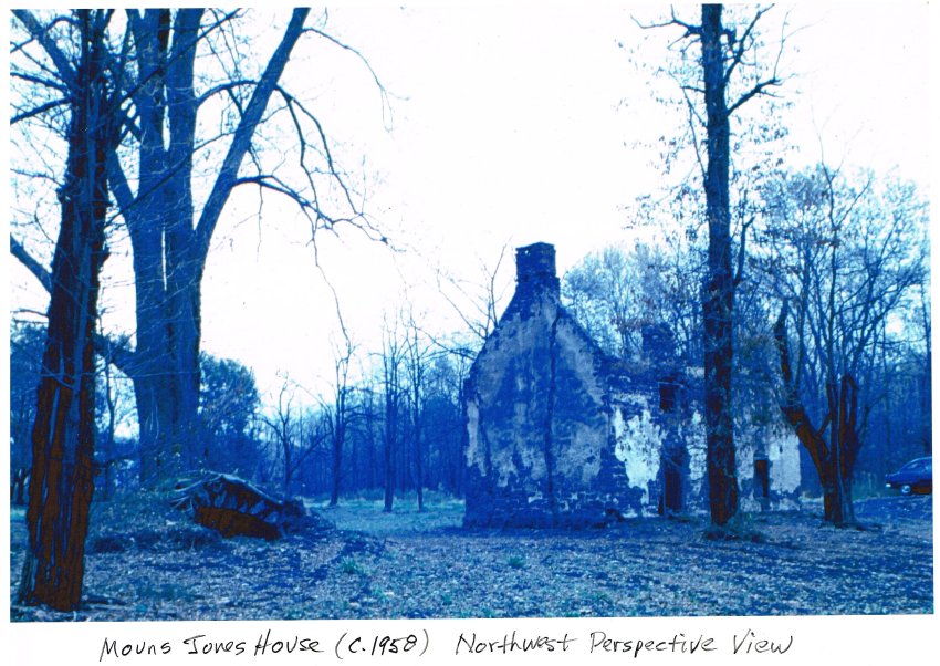
Archaeological excavations on the river side and to the northwest of the 1716 house, begun in 2012 and continuing through 2016, have unearthed well-masoned wall segments and possibly a stone stair to an opening in the wall [photo # 5918, 11/26/13]. Excavations in 2016 unearthed the remains of a root cellar [photo # 20, 10/15/16 shows the arched entrance to this structure in a photo of c. 1960 by Harry Stauffer], and a masoned stone well, with a dressed-and rubble-stone retaining ring at grade [photo 14, 10/19/16]. These features will be explored further to determine their original forms, dimensions, and artifact context.
It seems reasonable to assume that Mouns' wife and six young children delayed their move to the new "plantation" until the erection of the first dwelling and reasonable assurances of amicable relations with the natives, which contingencies were probably not met until after 1704. Mouns annexed acreage to his Kingsessing land as late as 1708, indicating that he, possibly in conjunction with his brothers, still had an interest in the family holdings on the lower Schuylkill.
An analysis of the historical interaction and land transactions between the Swedes and the Quakers, leading to the Swedish settlement at Morlatton, appears in "The Origin of the Swedish Settlement At Old Morlatton" by Philip Pendleton, published in Historical Review of Berks County, Vol. LIII, Number 3, Sept. 1988, pages 129 et seq. This study is based on wide-ranging research in contemporary public records and other primary sources. The complex and controversial relationship between the Swedes and William Penn is acknowledged and analyzed, while recognizing that the primary chronicler of the facts and legal nuances from the Swedish landholders' perspective was "highly biased." There is no question that Penn's sons and agents assumed an aggressive posture toward Swedish land-title claims in Penn's "Green Country Towne" and the contiguous tracts. Nevertheless, neither Penn's policies and tactics nor John Bartram, had anything to do with Mouns Jones divestment of his Kingsessing land holdings and stone house.
The notion that Mouns Jones conveyed his Kingsessing house and land to John Bartram [or to anyone else] under duress or threat of an adverse title claim asserted by Penn or his agents is unfounded mythology. The first phase of the two-step "exchange" would have consisted of Mouns Jones' acquisition of the Manatawny tract by 1704, when he was in residence there according to Reverend Sandel's letter. In 1704, John Bartram was about five years old.
Mouns continued until 1712 to hold title to his house and a share of the family land holdings southwest of Philadelphia near the Schuylkill River just above its confluence with the Delaware. In 1712 the house and Mouns and Ingeborg's share of the family acreage was conveyed to their son-in-law Frederick Schopenhausen and their daughter Christina, then 16 years old. John Bartram, then about three years younger than Christina, would not acquire the Mouns Jones farmstead for another 16 years, when he purchased it at a Sheriff's sale occasioned by Schopenhausen's insolvency. The Penn Proprietors had no involvement in any of the land transactions involving Mouns Jones or his real estate in 1702-04, 1712, or 1728. There was simply no "exchange" between Mouns Jones and Bartram, brokered or coerced through "Friendly Persuasion" by Penn interests or otherwise.
The 1701 land grant of 10,000 acres to the Swedes, represented by Reverend Andreas [Andrew] Rudman 50 miles northwest of Philadelphia, was not an isolated or spontaneous gesture by William Penn, but was a rational component of the plan to populate his well-wooded and generously watered Province. In his 1683 "Letter…to the Committee of the Free Society of Traders," Penn manifested a grand vision for settlement of the valley corridor straddling the "Skulkill," which he believed to be "an hundred Miles Boatable above the Falls{d}, and its Course North-East{e} toward the Fountain [headwaters] of the Susquahanna [sic]….it [the Schuylkill Valley] is like to be a great part of the Settlement of our Age."
According to Penn, conditions in the southeastern valleys of his Province were ideal for pioneering planters, traders, "yeoman" and skilled journeymen and their families who would fulfill his economic, ecumenical, and social vision: "The Air is sweet and clear, the Heavens serene…the Waters…good," and the Natives, though benighted in religious matters, "liberally" friendly and benevolent trading partners and, for the time being, amicable neighbors.
In 1702 the early Pennsylvania German Pietist Daniel Falckner answered "The 59th Question" posed to him respecting the virtues of Pennsylvania and America for prospective immigrants by comparing the manifold watersheds in the new territories to "an irrigated garden," an impression undoubtedly shared by Penn and woven into the marketing plan for his vast neo-feudal holdings.
In 1709 Mouns Jones and others signed a Petition to the Court in Philadelphia representing that they "had plantations"{f} which required a road for access to and from Philadelphia and Germantown, averring that it was "difficult" for the Petitioners to "pass and re-pass unto their plantations" in "Mannitawny". The Petition was not acted upon, and another (successful) plea for a road was submitted by Jones and his neighbors in 1715 and granted by 1719, as confirmed by the "Draught" published in archive record #MVFN1.
DETAILED CAPTIONS
Image #1: Falckner 1704 MAP: Digital reproduction of map published in a 1704 edition of Daniel Falckner's "Curieuse Nachrichte von Pensylvania in Norden America."
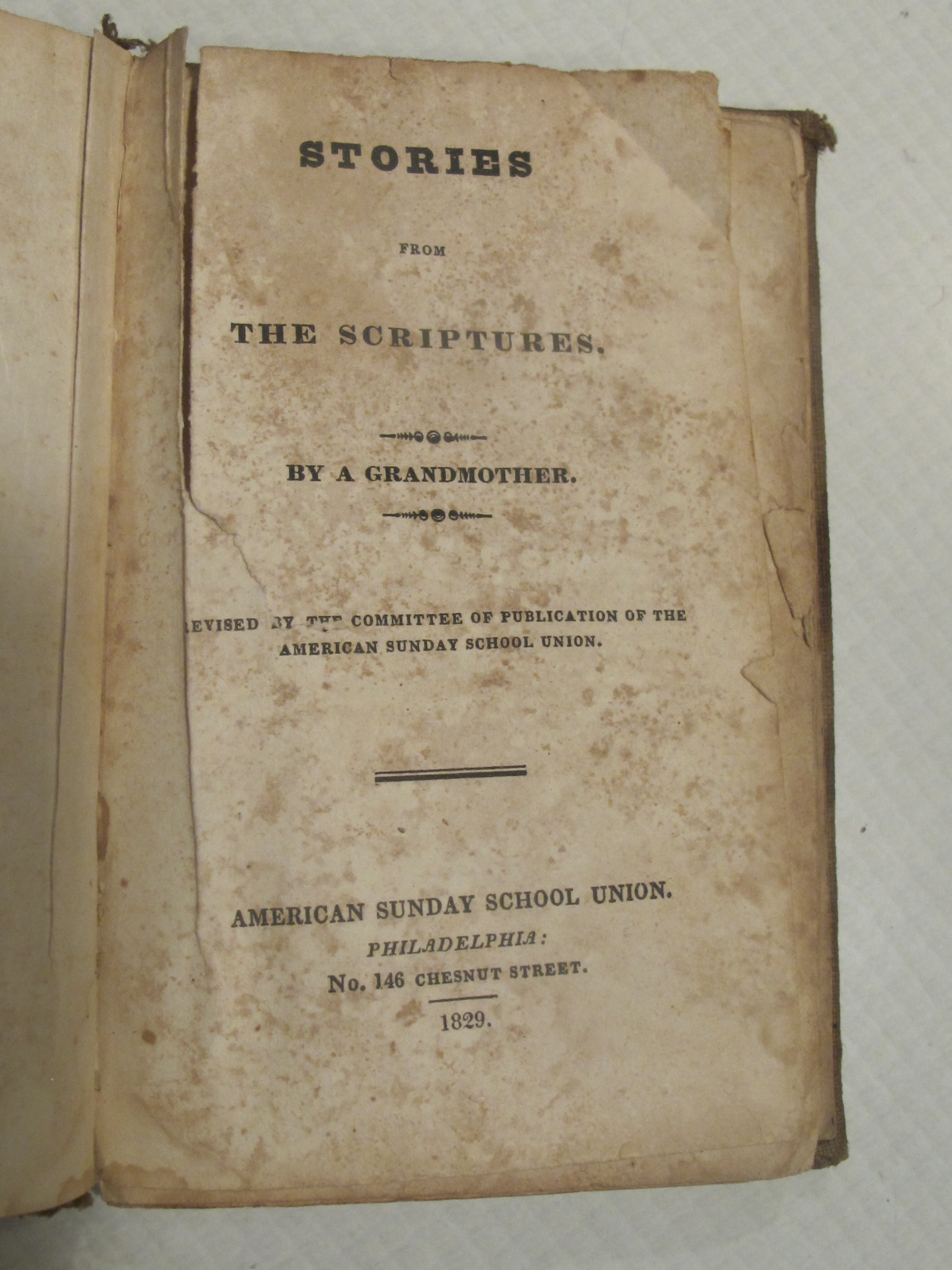
#2: photo 2598: title page from 1829 American Sunday School Union imprint ["Stories from the Scriptures" by "A Grandmother"] appearing in the St. Gabriel's Church ibrary.
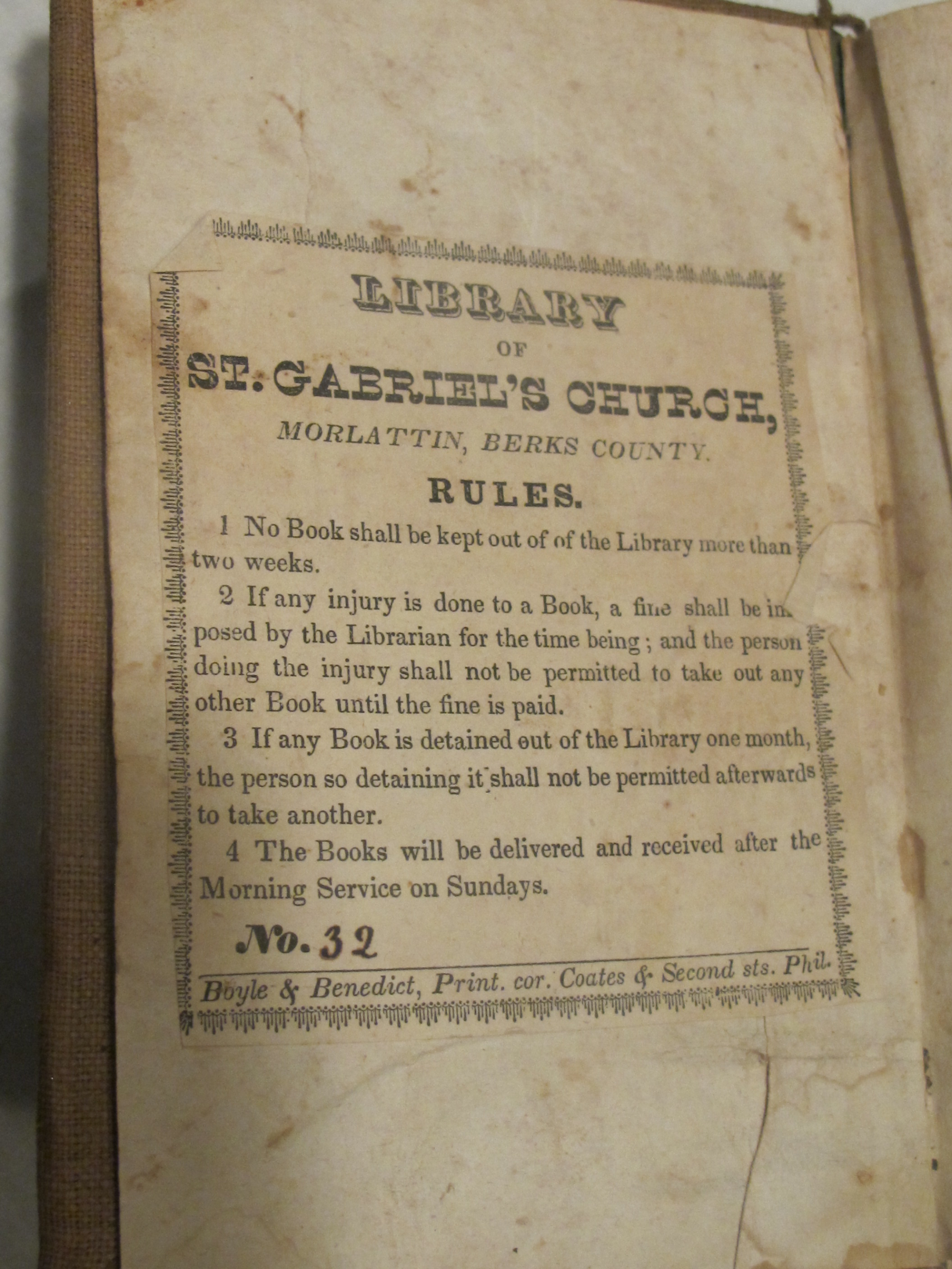
#3: photo 2599: printed ownership bookplate, opposite the title page of image #2598, describing the Church's location as "Morlattin, Berks County".
#4: photo 5918: Below grade masonry walls and passage opening within 20 feet of the 1716 house.
#5: photo 20: Exterior ["extrados"] of arched root cellar.
#6: photo 14blue-tone "cyanotype" photo by Harry Stauffer showing stone-arched entrance to a root-cellar.
#7: photo 14, 10/19/16: Stone well and abutments [pump-platform base?] at grade.
FOOTNOTES:
{a} Also spelled "Mannitawny," "Mannatawny and "Mahanatawny by Henry Melchior Muhlenberg and other 18th century journalists.
{b} under a warrant issued by 1702 and conferring the right to possess and eventually purchase the tract. Sandel's letter makes no mention of Mans' wife or children, who probably remained for a time period on the earlier Nilsson-Jonasson [later "Jones"] farmstead.
{c} The "Mannitawny" [also "Mahanatawny" and "Manatawny" in contemporary records and accounts] Creek, providing the place-name for the region, and the other tributary to the north, called the "Monakasy," later "Monocacy." Paul Wallace's rendering of the Perkiomen "Indian Path" shows native American Indian village sites at the Manatawny confluence [present-day Pottsgrove] and near the Douglassville [then "Manatawny"] site where the path, and subsequent road-beds, turned northward toward present day Amityville. Wallace notes that Manatawny was "an important station for a principal body" of migrant Delaware Indians [Indian Paths of Pennsylvania (1965), p. 127]. Thomas Kitchin's Revolutionary War era map of the "Seat of War in the Environs of Philadelphia" designates the village on the Reading-Philadelphia Road and nearby Creek as "Monotomy". The map appears as the frontispiece to Vol. III, Pennsylvania Archives, Series III, Harrisburg (1875).
{d} Presumably the falls at the confluence of the Schuylkill with the Delaware southwest of Penn's "Green Country Town."
{e} Penn's geographical references to the "Skulkill" apply more accurately to the orientation and compass bearing of the Delaware River channel, which projects generally "North-East" from Philadelphia as far as Trenton. The Schuylkill's channel reaches toward the northwest from Philadelphia. Most of the Schuylkill waterway is shallow much of the time, but would nevertheless be frequently navigable ["Boatable"] for the shallow-draft flatboats [sometimes called "canoes" in the period] fabricated and deployed by the Swedes and Finns in the region.
(f) see record #MJTX10 for a discussion of the dual meaning of "Plantation" in early Pennsylvania
{g} As narrated on pages 945 and 946 of "History of Berks County in Pennsylvania" by Morton L. Montgomery, Philadelphia, Everts & Peck (1886), excerpted from the published Colonial Records. See archive record MJHTX5--1000.01.093 for a catalogued copy of the 1709 manuscript Petition.
Laurence Ward, October 2016, updated December 2016.
Catalog details
- Catalog number
- 1003.01.054
- Alternate number
- MVTXT5
- Accession number
- 1003.01
- Date
- various
- Object name
- List of Documents
- Record type
- Archive
- Classification
- Documentary Artifact