Description
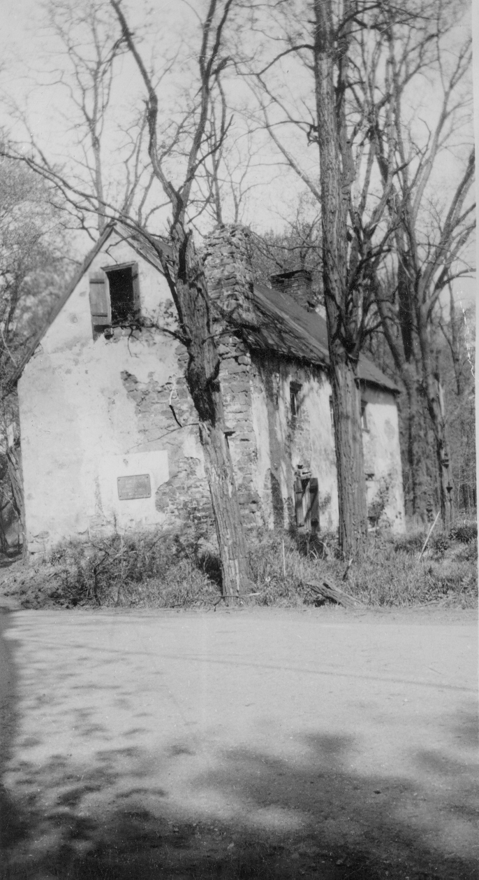
Three black and white photographic prints (two showing southeastern perspective views and one southwest perspective view), of the Mouns Jones House in the 1940s, before its partial collapse prior to 1958; a photo of notes on the verso of Image #1; one color photo of subgrade masonry on the river-side of the house; a map of the “Philadelphia Trading Area”; and a color interior photo of the masonry delineation of the roughly centered early doorway in the SW eaves wall.
Image #1 (c.1948-50) was taken from across the roadway [lighter colored material across bottom quarter of photo] which crossed the covered bridge to Union Township.
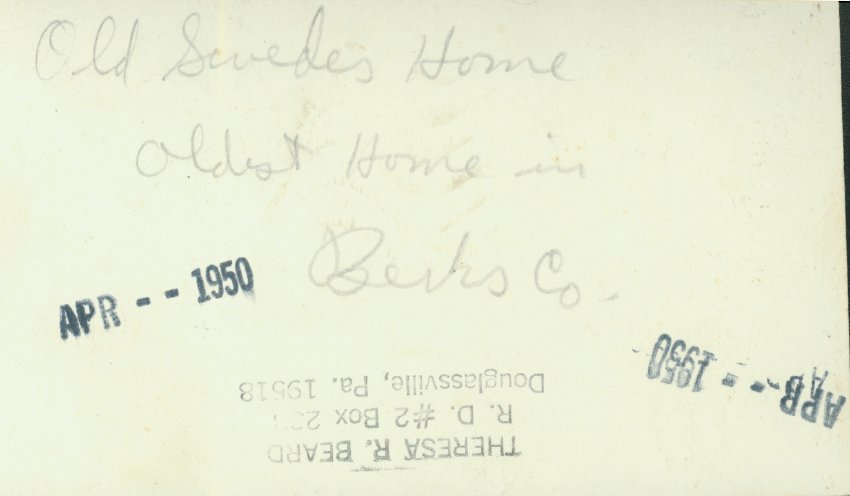
See image #2 for pencil note ["Old Swede's House, Oldest Home in Berks Co."] and "1950" stamped in black ink on verso.
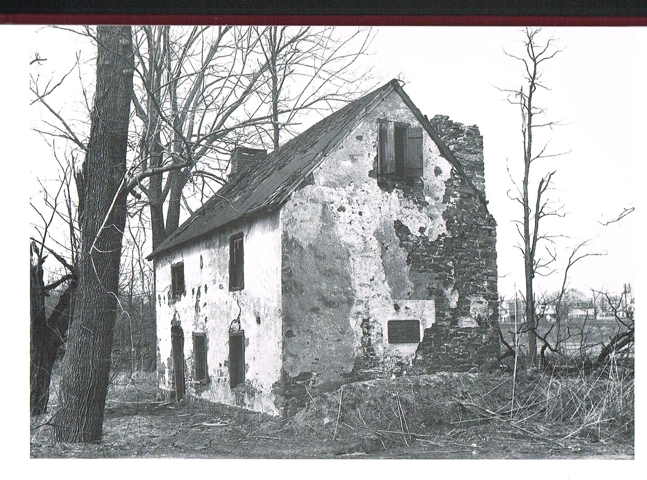
Image #3 (c.1948) more clearly depicts the vertical frames for hung-sash windows in the east eaves wall and shuttered attic window/access door. In these views the two visible walls appear to be intact up to the eaves and rake boards. Severe roof damage is more evident in Image #3, partly because of the perspective. The southeast corner chimney shows significant loss of stonework below the ridge-plane.
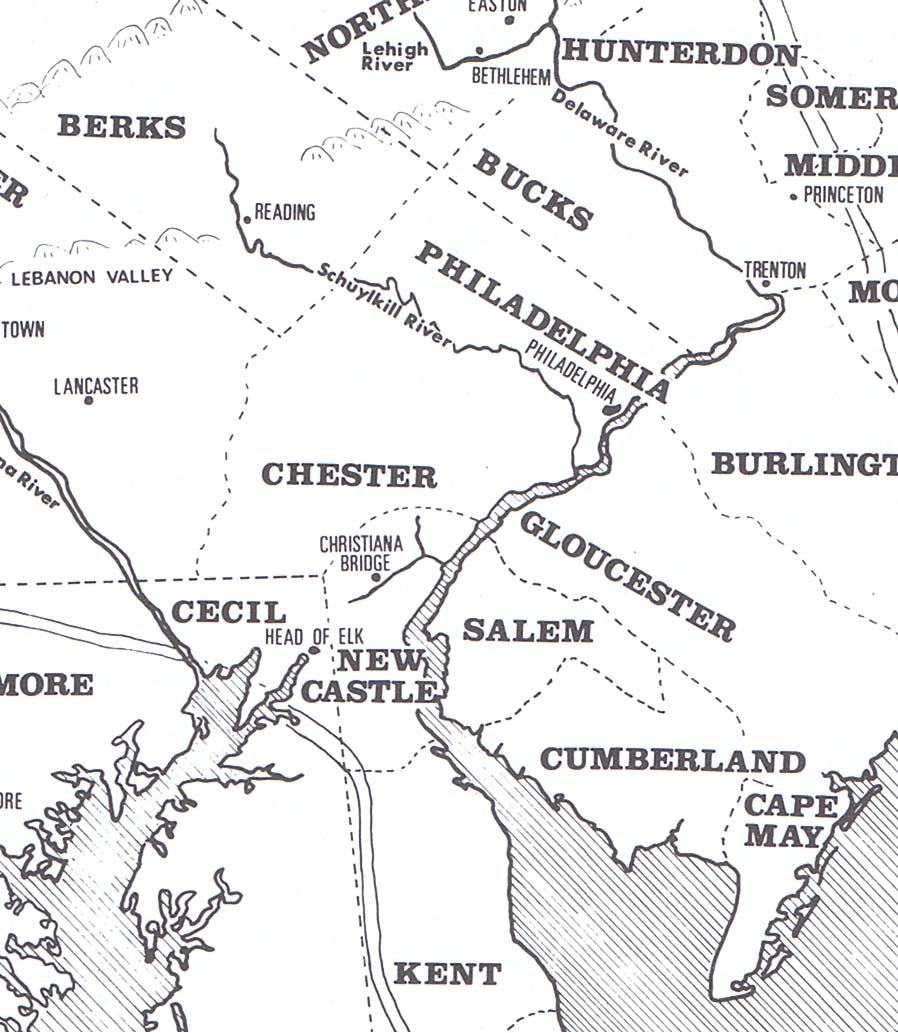
Image #4 is a map of the "Philadelphia Trading Area" as of c. 1760.
Image #5 is a perspective view from the southwest taken from near the ramp to the covered bridge, which was demolished c.1951.
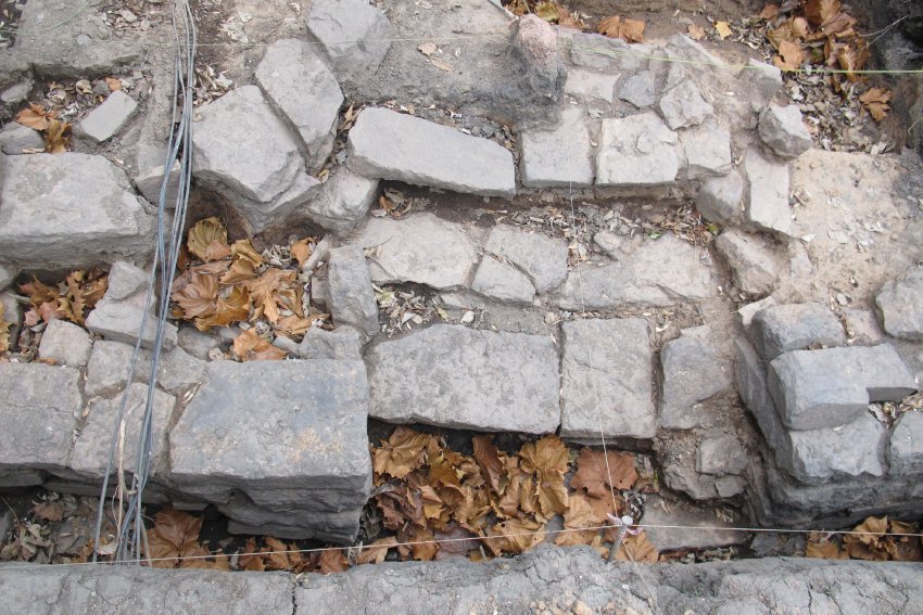
Image #6 [photo 5916, 11/26/13] appears to show stone steps descending through a passage between sub-grade walls.
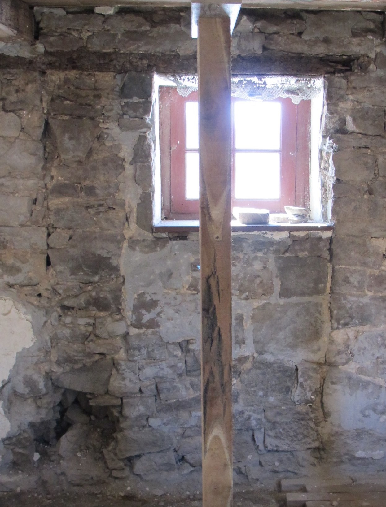
Image # 7 [photo #6863, 1/30/14] is a photo of the interior stonework ["wythe"] of the western eaves wall, clearly showing the masonry delineation of the original centered doorway.
An August, 1958 HABS photo from a southeast perspective shows that the roof, eastern wall plate[a], and significant stonework from the upper range of the east eaves wall had collapsed [see MJHPH16--1000.01.016].
[a] also called a "rafter plate" when the rafter feet are seated on or notched through the timber plate.
Details in Images ##1, 3, and 5 include: Vertically-framed window openings in the eaves wall and gable; battened shutters; random-rubble masonry corner chimney; capped brick gable-end chimney; eroded pargeting residue; roof damage exposing earlier shingles, rafters, and lath. Photographer of Image #3 was Walter A. Romanski; thanks to George M. Meiser IX for generous permission to publish an edited print of this image from Passing Scene Volume 9, page 247 (1994).
The 1716 "Oldest Home" has also been designated as the oldest "surviving" dwelling in Berks County; the "first" house in Berks; the longest surviving stone structure; and similar labels. The extant masonry structure was not Mouns Jones' first house in present-day Berks County, but was, in 1716, probably one of the few outermost plantation houses on the northwestern frontier of Philadelphia County. It survives indisputably as the longest-standing well-documented dwelling in Berks.
An extract from the "Reformed Church Record" of Jan. 24, 1907, published in the "Pennsylvania German" magazine issued in March, 1907 at page 134, recites that in 1693 Swedish Lutheran church leaders in Pennsylvania petitioned Church officials in Sweden for two additional ministers for their flock. One of the appointees was Andreas Rudman, who applied for and was granted 10,000 acres by William Penn in 1701, to be distributed among himself and his fellow Swedes who were willing to take up land in the remote region between the confluences of the Manatawny and Monocacy Creeks with the Schuylkill River. Mouns Jones was granted slightly less than 500 acres of this immense Penn grant in 1705, when he received his patent, having "taken up" [accepted a warrant for survey, and agreed to acquire] the parcel in 1701 and having constructed his first dwelling there by 1704.
Colonial records of 1704 include correspondence from a traveling minister [Reverend Andreas Sandel] indicating that "Mans Jonson" had "taken up" residence in Mannitawny, probably in a log or plank-sheathed house which served the eight-member family until the stone house was ready for occupancy by 1716. The Sandel letter makes no reference to any family members in residence as of 1704. It should be noted that Mouns Jones continued in ownership of his share of the family's Kingsessing Township holdings until 1712, and that he purchased meadow land adjoining the family farmstead as late as about 1708, suggesting that he was not completely divested of his working interest in the Kingsessing tract four years after first "residing" at his Manatawny plantation.
A comprehensive analysis of the historical interaction and land transactions between the Swedes and the Quakers, leading to the Swedish settlement at Morlatton, appears in "The Origin of the Swedish Settlement At Old Morlatton" by Philip Pendleton, published in Historical Review of Berks County, Vol. LIII, Number 3, Sept. 1988, pages 129 et seq. Swedish minister Justus Falckner's 1704 map of Pennsylvania and West New Jersey [see record #MVTX5] records no place-names or waterways near the location of the embryonic Manatawny settlement on the upper reaches of the Schuylkill River.
Although a few tributaries are shown northwest of "Plimouth" in present-day lower Montgomery County, none are indicated for the confluences of the Manatawny and Monocacy creeks with the Schuylkill River, or for the mouth of French Creek (south of “Mahanatawny”), where Peter Bezaillion had taken over a trading post and built a house by 1700 [see footnote {g} below]. There is no cartographic indication of the presence of Mouns or any other member of his family striving, with considerable success [including substantial mercantile activity involving imported goods purchased from James Logan and trade with the indigenous natives], to develop their farmstead and to co-exist in secure "amity" with natives within the blank frontier along the upper margin of Falckner's map.
A partial chronology of Jones activities relating to his "plantatation" on the Schuylkill River appears in archive record MJHPH57--1000.01.061. An on-line historical and genealogical account has asserted: "Situated adjacent to the White Horse Ford{b}, his original log cabin built in 1701 was replaced by a stone dwelling in 1716." No source is cited for the 1701 date ascribed to the log house, and it probably relates to Mouns Jones having "taken up" the warrant for the acreage in October of 1701. The "Patent" [Deed-equivalent] for the land was issued to Mouns on May 15, 1705, confirming his ownership].
{b} this statement is anachronistic, since the White Horse Ford did not bear that name until the mid-18th century according to contemporary maps, approximately in the same time period in which Huling's Publick House [in his "former residence" near the river some few hundred yards south of Mouns Jones's house] was first called the "White Horse Tavern", later moved to the present tavern structure north of Old Philadelphia Pike. It is also incorrect as to the location of the White Horse Ford, almost certainly crossing the river a few hundred yards north of Mouns Jones house, near the extant stone pier-abutment for the railroad bridge, where the slopes on both sides of the river are much less severe than those fronting Jones's house lot. An archaeological excavation immediately northwest of the river-front eaves wall has been ongoing since 2011 and extended in 2015 toward the north. One objective of this dig is to determine the extent, and hopefully the function, of the sub-grade stonework visible in 1970 photographs in the Trust's archives [see MJHPH57--1000.01.061] and in Image #6 in this record, [photo 5916, 11/26/13] which appears to show stone steps descending through a passage between the sub-grade walls.
It is possible that the masonry unearthed in 1970 and again in 2013 was a foundation for an earlier house [possibly the c.1702-1704 log cabin], with a cellar entry; an ancillary "plantation" structure; an addition to the surviving house; a porch or similar extension of the living space; a stoop foundation; or a retaining wall. See Image #7, photo 5361, 11/4/13. The doorway near the center of the east wall (facing away from the river) had been closed up with masonry in-fill before 1958: see photos in MJHPH40--1000.01.044, MJHPH43--1000.01.047 & MJHPH73--1000.01.078]. It seems likely that the door was walled up for reasons relating to a re-allocation and partitioning of the interior space on the first floor. If the partition wall between the hall and the parlor was originally south of the doorways aligned on an eccentric transverse axis, both exterior doors would have provided direct access to the hall-kitchen. This arrangement would isolate the smaller parlor as the more private space, accessible only from the hall through the doorway in the interior partition wall [removed prior to the 1957: see the HABS drawing in archive MJHDWG1--1000.01.019].
This privacy feature and interior access through the Hall provide the basis for the term "inner room," an early English equivalent for "parlor", expressing a common plan-form in transitional Anglo-Pennsylvania three-bay houses of the period, most of which include a pre-Georgian single partition dividing the hall from the parlor. Walling up the central doorway in the east eaves wall and relocating the doorway in the west [river-side] eaves wall to the north bay allowed the shift of the board partition northward, enlarging the parlor at the expense of the "hall", perhaps relegating the latter space primarily to that of a kitchen. According to the 1957 HABS drawing [Atlas sheet #1A], the 19th century partition terminated at both eaves walls at the masonry which closed-up the original centered doorways, so it could not have been the original alignment of the partition between the Hall and the Parlor. This closure would have achieved the objective of establishing a relatively larger, but still more private, parlor space.
In 1709 Mouns Jones and others signed a Petition to the Court in Philadelphia representing that they "had plantations" which required a road for access, averring that it was "difficult" for the Petitioners to "pass and re-pass unto their plantations" in "Mannitawny"{c}. The Petition was not acted upon, and another plea for a road was submitted by Jones and his neighbors in 1715. The regional road system was in fuller development by 1719 [see "Draught" of a road survey in this record]
{c} As narrated on pages 945 and 946 of "History of Berks County in Pennsylvania" by Morton L. Montgomery, Philadelphia, Everts & Peck (1886), excerpted from the published Colonial Records. See archive record MJHTX5--1000.01.093 for a catalogued copy of the 1709 manuscript Petition. For reasons discussed in other records in this archive [see, e.g., the discussion of the 1724 Abiah Taylor House below, and similar houses listed in MJHPH67--1000.01.072], the extant Mouns Jones masonry house expresses many Anglo-Pennsylvania attributes{d} and at least one element, the corner fireplace, which is ambivalent as to ethnic architectural influence. Numerous diagonal ["cross-corner"] fireplaces appear in Quaker and other English Hall-Parlor type dwellings in southeastern Pennsylvania, as well as in 17th- and early 18th century Pennsylvania-Swedish log houses{e}.
{d} The three-bay English transitional house type, emerging between "Medieval" forms and Georgian "detached" prototypes, usually featured a centered doorway in the primary façade, though not always expressing perfect symmetry in fenestration. The doorway in the west eaves wall is now in the northern bay of that elevation, entering directly into the northern ['fireplace"] bay, where it has been located since 1886 or earlier. The Quaker form typically separates the hall from the parlor with a single partition wall, creating the desired privacy in the "inner room" [parlor] and the functional expansiveness of the hall-kitchen.
{e} One example on Darby Creek near modern Clifton Heights is well documented in a series of HABS drawings captioned "Lower Swedish Log Cabin…Survey…PA. 135". Other surviving examples of early Pennsylvania-Swedish two-room log cabins set along Darby Creek , also with corner fireplaces, are described and shown in photos in the essay "17th Century Swedish Log Cabins Survive" by Thomas Smith appearing in the January, 1975 issue of "American Folklife," Vol. III, No. 4, page 2.
The documented masonry evidence is consistent with central {x} locations for both original doorways aligned on a common transverse axis through the eaves walls [see Description and footnote {1} in MJHPH67--1000.01.072, and images #2 and in that record]. The mid-20th-century HABS and other pre-1966 photographs clearly show the "ghost" outline of a centered doorway in the east elevation. See MJHPH67--1000.01.072 for further discussion of the probable original central alignment of both doorways in the eaves ["long"] walls and other attributes of the Anglo-Quaker type manifested in Mouns Jones' house. Photo #6863 in this record shows the delineation of the centered doorway after recent removal of the 1970 plaster coating from the interior west eaves wall, confirming its typical location under the date-stone.
Although it is possible that Jones specified a corner fireplace as a domestic element from his Swedish heritage, it is equally likely that the vernacular artisans who built his imposing 1716 house, including the fireplace masonry work, were drawn from the large and experienced corps of English and Welsh masons, carpenters and joiners, and journeyman in both trades. English craftsmen were erecting stone buildings and producing fine carpentry and joinery in Philadelphia in the early 1680s. Mouns Jones father Jonas Nilsson operated a masonry trading post west of the lower Schulkill River in the region then known as "Kingsessing". Journeymen trained in Philadelphia in the "art and mystery" of their trades had "journeyed out" to developing communities to earn their livelihood. These builders were undoubtedly available in Chester County, Pine Grove, and other settlements in the expanding "Philadelphia Trading Area"{f}. They were perfecting their skills by experience as apprentices and journeymen under earlier immigrant or 2d generation "masters". This growing corps of craftsmen built numerous houses during the first quarter of the 18th century in the basic form prescribed or authorized by Mouns Jones. This type was prevalent in the "Trading Area", which was co-extensive with the widening zone of architectural influence [for further discussion of the Anglo-Pennsylvania influences on the hall-parlor plan-form and “single-pile” three-bay massing of this dwelling, see MJHPH67--1000.01.072].
{x} but not precisely centered: the original and now re-opened doorways are aligned approximately 5” south of the central vertical axes of the eaves walls.
{f} The attached image #4 is the portion of a map of the Philadelphia Trading Area which includes the Manatawny region. The entire map, showing the expanded radius as of 1760, is published in Winterthur Portfolio Volume 7, at page 162. This map shows the region of commercial and agricultural development within the sphere of influence of Philadelphia's culture, economy, and building-craft traditions. This interdependence between settlements in the region is the subject of the scholarly essay "Colonial Philadelphia and Its Backcountry" by John F. Walzer, beginning at page 161 of the Winterthur volume cited above. The "Trading Area" also closely approximates the zone of influence of early 18th century Philadelphia architecture, particularly Quaker design preferences, which are considered in MJHPH67--1000.01.072 as the probable source of the plan, interior spatial arrangements, and essential details of Mouns Jones' 1716 stone house. By 1716 a Quaker master mason in Manatawny, Samuel Savage, was living and presumably employing his craft in Pine Forge, just a few miles north of Mouns Jones's new stone house. Thomas Millard, a skilled carpenter trained in Philadelphia, had established his grist mill less than a half a mile downriver on the opposite bank several years earlier. Along the mid-Atlantic seaboard, a common English [but not necessarily Quaker] house form in the late 17th chamber, was composed of the "Hall," with exterior doors through both long walls, and the "Parlor," accessible only from the hall. This form prevailed in the southern portion of the region, though in its contemporary and parallel emergence in Virginia it tended to be erected to one-and-one-half stories no matter what level of affluence the owner enjoyed: see "Vernacular Domestic in Eighteenth-Century Architecture in Virginia" by Dell Upton, Winterthur Portfolio Vol. 17, Numbers 2/3 (1982), pp. 95-96. Pennsylvania houses following this plan, including all cited in this record, were likely to be two-and-on-half stories and one-room deep [sometimes called "single-pile", though not within the original meaning of this term]. In Willistown township, Chester County, 18th-century Quaker "Hall-parlor houses…are always 2 ½ stories high, with chambers on the second floor and attic storage." [Frens, Dale H., "Vernacular Plan Forms in Willstown Township Dwellings, published in "Acres of Quakers" (2006), p. 95, edited by John Charles Nagy and Penny Teaf Goulding]. This house type in Willistown also typically had aligned doors centered in the eaves walls, a large open-hearth fireplace and a box-winder staircase filling the gable end wall the hall gable wall, a fireplace-heated parlor entered only from the hall through a board partition wall, which was less-commonly plastered [Ibid]. All of these elements existed in Mouns Jones' house as originally configured. The first Abiah Taylor House [1724] is a representative Chester County example in brick, a hall-parlor plan with centered doorway in the long walls, asymmetrical fenestration, and a diagonal corner fireplace [see the article "Vernacular Expression in Quaker Chester County…" by Arlene Horvath published in "Perspectives in Vernacular Architecture, II" (1986), which thoroughly analyzes this house and the later Taylor-Parke House in their expression as Quaker prototypes]. Other contemporary houses of this Anglo-Pennsylvania" type are listed and briefly described in archive record MJHPH67, footnote {2}. The brick examples of this type prevail in the eastern portion of the region, including West Jersey{g}; random rubble or roughly coursed stone examples predominate in the western segment.
{g} In a scholarly analysis of 18th West New Jersey brick houses, Michael Chiarappa documents the "powerful role of Quakerism" in the social fabric and domestic architecture in his essay “The Social Context of Eighteenth-Century West New Jersey Brick Artisanry”, published in Perspectives in vernacular Architecture, Vol. IV, p. 31. This role seems to parallel the diaspora of architectural and cultural Quaker influence in the wide corridor linking Philadelphia and the contiguous unties northwest of Philadelphia and west of the Delaware River. Mouns Jones House was erected at the periphery of this radiating domain of Quaker influence; its three-bay, two-room plan with a corner fireplace is emblematic of a plan common in the first half century of Quaker influence in the "Trading Area." The type is expressed in numerous houses, extant and extinct, in the region.
As late as 1750, the population of the Schuylkill Valley region encompassing "Molatton" was still primarily of English ancestry, with nodules of Germanic[h] and Swedish Pennsylvanians straddling the river [see the demographic map prepared by Hope Levan, and the related analysis by Philip E. Pendleton on pages 17, 68, and 69 of "Oley Valley Heritage, The Colonial Years: 1700-1775," co-published by the Pennsylvania German Society and The Oley Valley Heritage Association in 1994].
French immigrants, including “Captain” James Le Tourt and Peter Bezaillion [various spellings] were engaged by the last decade of the 17th century in “the provision of trade goods for the Indians and shipment of furs to England.” [See “Peter Bezaillion’s Road” by Martin Hervin Brackbill, published as Volume XLIII, No. 1 of the Papers Read Before The Lancaster County Historical Society (1939). In extensive citation of Colonial records, Brackbill traces Bezaillion’s mercantile and land dealings through 1717, including his “having built a house in the fall of the year 1700 on a tract of land over against Mahanatawny…”. This tract, originally granted to Matthew Brooks, was situated on the west bank of the Schuylkill River near the mouth of French Creek in Chester County (near present-day Phoenixville), well south of the confluence of the Manatawny Creek with the Schuylkill River [Brackbill, p. 27]. Bezaillion’s 1700 house pre-dates Mouns Jones first residence in the northern sector of “Mahanatawny” by only a few years. Mouns Jones and Bezaillion were contemporaries living and trading in the Schuylkill Valley from the late 17th century through the first quarter of the 18th, purchasing wholesale lots of goods for re-sale and as barter for furs acquired from Native American trading partners.
{h} Demographically consolidated or ethnic population clusters do not prove attributable architectural influence on any particular or iconic characteristics in early houses. Nevertheless, a combination of a strong English presence in the developing populations of upper Philadelphia County, extending in the first quarter of the 18th century to the Manatawny settlement, and the documented availability of experienced English-tradition craftsmen in the early period, are consistent with the transitional "Anglo-Pennsylvania" characteristics of Mouns Jones house.
Laurence Ward, 2014, Updated June 2016, June 2018, Sept 2020
Catalog details
- Catalog number
- 1000.01.065
- Alternate number
- MJHPH60
- Accession number
- 1000.01
- Date
- c.1948-1950
- Creator
- Unknown (image #1) & Romanski, Walter A. (images #3 & #5)
- Object name
- Print, Photographic
- Record type
- Standard
- Classification
- Documentary Artifact
People
Subjects and search terms
Mouns Jones HousePhiladelphia InfluenceQuaker PlanPerspective PhotoWindow FrameBattened ShutterHall-parlor PlanBrick ChimneyMouns Jones House PhotoManatawnyAttic WindowShingle RoofVintage PhotoShutterMonotonyPhiladelphia Trading Area MapmapdoorwayBoard & Batten ShutterStone ChimneyMahanatawnyeaves wallMJHPHQuoin Corner PierMJPHGable-End ChimneyChimney CapPargeingRoof DamageParged MasonryMJHShinglesCorner Chimneyinner room