Description
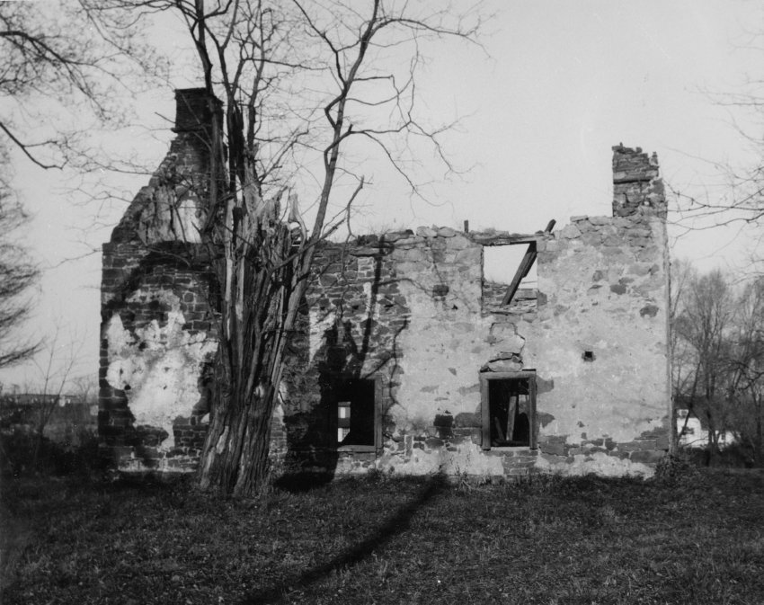
Black and white photographic print showing west elevation view of surviving masonry wall, chimneys, and fenestration openings on both stories of the Mouns Jones House. A HABS drawing dated 1957 shows the standing masonry walling after the collapse of the roof and flooring [see sheet # 1A of the Atlas of Drawings of Structures Preserved by The Historic Preservation Trust of Berks County, PA (Douglsasville, PA: 2008)]; this drawing delineates the surviving and missing masonry by dashed lines and confirms that a substantial majority of the stone walls and both chimneys remained standing, the masonry losses having been confined to the few courses above the 2d storey window openings.
Details include: gable-end chimney on the north gable wall [left], corner chimney in southeast corner [right], parged masonry walls, 19th-century window openings and frames for hung-sash, empty datestone niche.
Compare window openings, proportions, and alignment in this photo to the artist's woodcut rendition [c.1886] in MJHDWG2--1000.01.089 and MJHTX4--1000.01.063. The two window frames in the south bay [right], with long vertical axes and altered masonry openings, were most probably post-1886 [and pre-c.1911] replacements of earlier horizontally-aligned casement windows similar to the 2d story window of the north bay in photo MJHPH44--1000.01.048, a contemporary view from a slightly different perspective. The central window opening on the first floor level was close to the probable location of the early [perhaps original] doorway, which would have been centered under the datestone{1}.
See photo MJHPH44--1000.01.048 for a possible interpretation of the dark rectangular detail to the right of and above the southern window on the 1st floor.
The substantial surviving stonework in this view, coupled with timber fragments found in the debris, provided some evidence for the approach and details implemented in the 1965-72 restoration of this elevation. However, later investigation determined convincingly that the original doorway was centered in this wall under the datestone [see discussion in record MJHPH67--1000.01.072].
The projecting stone "flashing course" seen on the west face of each chimney would normally locate the upper margin of the roof plane; however, the 1960s replacement roof was apparently set some distance below the elevation of these corbels, which are designed to shelter the joints between the chimneys and the roofing prior to the widespread use of copper or lead flashing [see photos MJHPH68--1000.01.073 and MJHPH69--1000.01.074]. The anomalies in the roof alignment include the rotation of the two roof planes off-axis and the apparent offset of the upper wall plates [functionally, "rafter plates"] outward from a plumb vertical alignment with center-line of the foundation plinth. The rake boards on the north gable appear to be slightly askew, rotated counter-clockwise. Measurements will be taken to determine the precise deviation from the true axes of the structure.
Because of this deviation from the structurally preferable plumb-line, the upper courses of both eaves walls were "battered" toward the east to support the wall plates and the replacement roof framing. These eccentricities produce less than ideal structural relationships and often compromise the stability of the walls subject to the compressive loads and oblique thrusts from the aggregate mass of the roof's timber frame and covering materials. Short "collar ties" connect the rafters about 6 feet above the attic floor. As a redundant measure, steel brackets will be applied in 2019 to mechanically connect several rafters with their conjugate joists to utilize the joists as tie beams reciprocally resisting the opposing thrusts of the two roof plane structural assemblies.
The rake boards on each gable-end of this building create an interior angle of slightly less than 90 degrees, an arbitrary mathematical rule-of-thumb defining a "steep" [sometimes termed "Mediaeval"] roof.
Note written in pencil on verso reads, "MJH--west elevation (c.1965)"
Note written in blue pen & stamped black ink on verso reads, "Mouns Jones House as it looked in 1965. Property of Mrs. [begin black stamped ink] John A. Beard XXXX - XXXXX [address withheld]".
FOOTNOTE
{1} The vacant rectangular niche for the missing oval datestone [later recovered and re-installed, and again re-set in the restored walling in the 2014-2019 restoration campaign] is visible above the central window, to the right of the tree branches.
Laurence Ward, April, 2019
Catalog details
- Catalog number
- 1000.01.071
- Alternate number
- MJHPH66
- Accession number
- 1000.01
- Date
- c.1965
- Creator
- Unknown
- Object name
- Print, Photographic
- Record type
- Standard
- Classification
- Documentary Artifact