Description
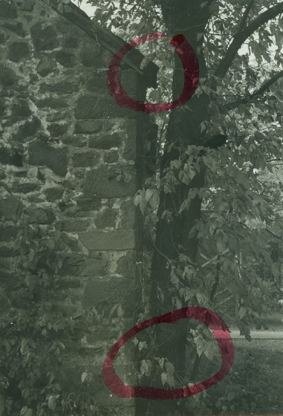
Digital image of a black & white photographic print showing detail of south gable wall.
Lower circle in red marker draws attention to the tree referred to in the pencil note on the verso. Upper red circle locates the junction of the western rake board on the south gable wall [detail of MFHPH17--1005.01.018] with the rafter [“wall”] plate borne by the east eaves wall.
Details include: random rubble masonry; lower segment of beaded rake ["barge"] board; "barn-dash" pointing, probably intended to "flush-out" the joints to prepare for 19th-century pargeting.
Note in pencil on verso reads: "finish of roof line at the eaves of toll [sic {1}] house east wall. tree growing out of wall must be removed 6'; beaded board along eave line, possibly pine, very plain board also along top wall line at rafters end. Toll House [sic: see MFHPH16--1005.01.017]."
Note in blue pen written over last two words in pencil reads "BRIDGE HSE"
The larger stones ["quoins"] stabilized the southeast corner segment sufficiently to withstand the April 1967 partial collapse. This ancient{2} structural technique utilizes the gravitational forces transmitted through the quoins and the foundation to the bearing-soils, keeping the corner pier in stable compression. This pattern of alternating large stones is designed to bind ["tie"] the vertical mortar joints in the smaller stones between them, creating a mechanically efficient, and virtually monolithic, composite pier and mechanically connecting the intersecting walls. This detail appears frequently in Pennsylvania German buildings in the region, and abounds in 17th- and 18th-century rural England and Wales, and in Pennsylvania colonial regions influenced by their craft traditions.
FOOTNOTES:
{1} Probably incorrect: the only known identification of a “toll” house associated with the Douglassville covered bridge appears on the 1876 Atlas map of Amity and Union Townships, which locates the “toll house” on the opposite side of the river from the Fulp house. SEE details on this point in MfHPH22.
{2} Appearing in un-dressed, sometimes coarse, form as early as the 10th century, and developed in French Gothic structures through the mediaeval period, often slightly projecting from the wall plane, and frequently with beveled edges ["arrises"]; in Anglo-Saxon vernacular called "long-and-short" work because of the alternating “Header-Stretcher” arrangement of the reciprocally-bonded blocks composing the structural corner pier. See additional discussion in photo record MFHPH32--1005.01.033.
Laurence Ward, June 2016
Catalog details
- Catalog number
- 1005.01.020
- Alternate number
- MFHPH19
- Accession number
- 1005.01
- Date
- c.1966-1967
- Creator
- Unknown
- Object name
- Print, Photographic
- Record type
- Standard
- Classification
- Documentary Artifact