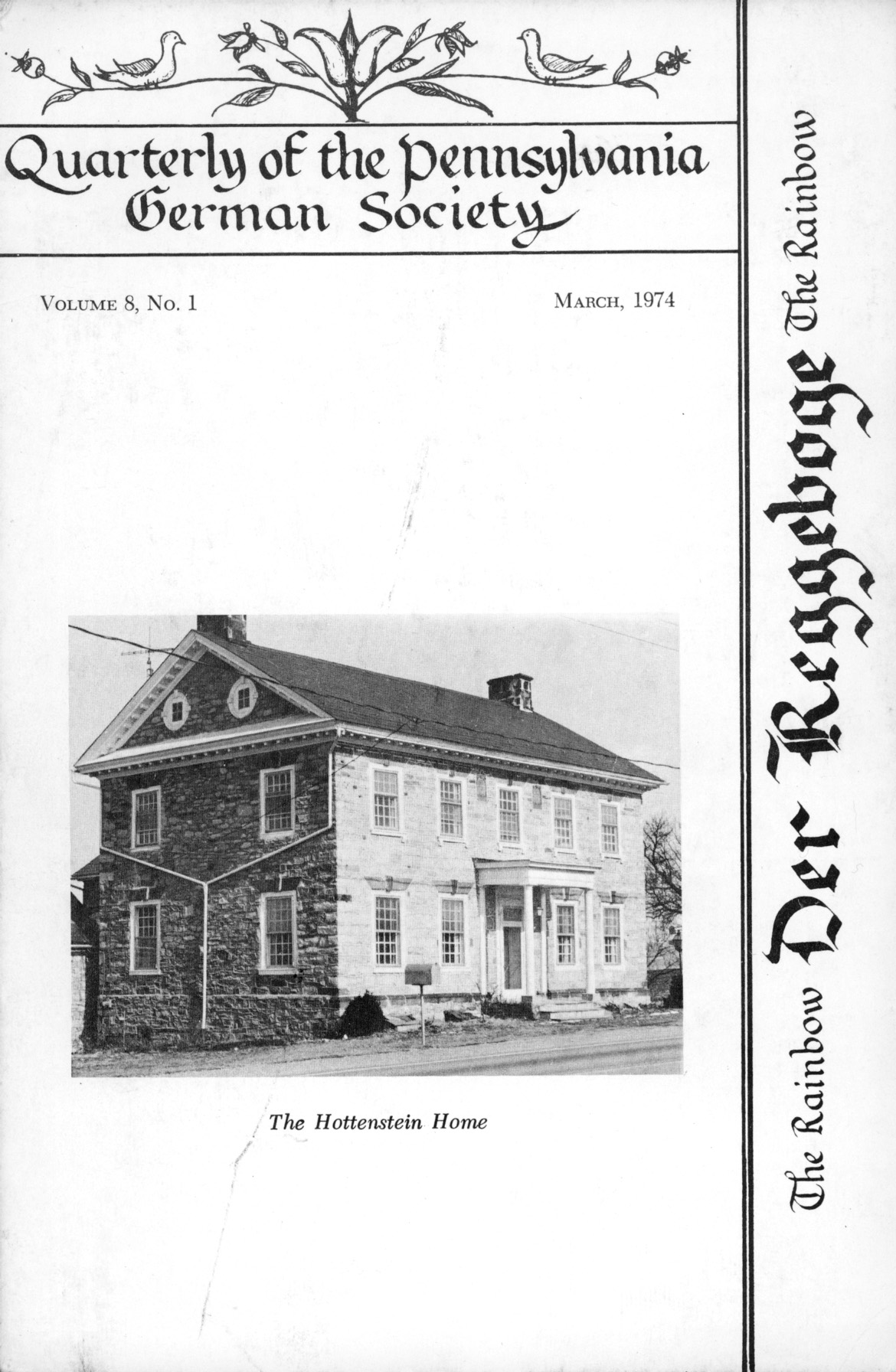
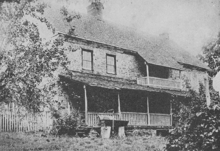
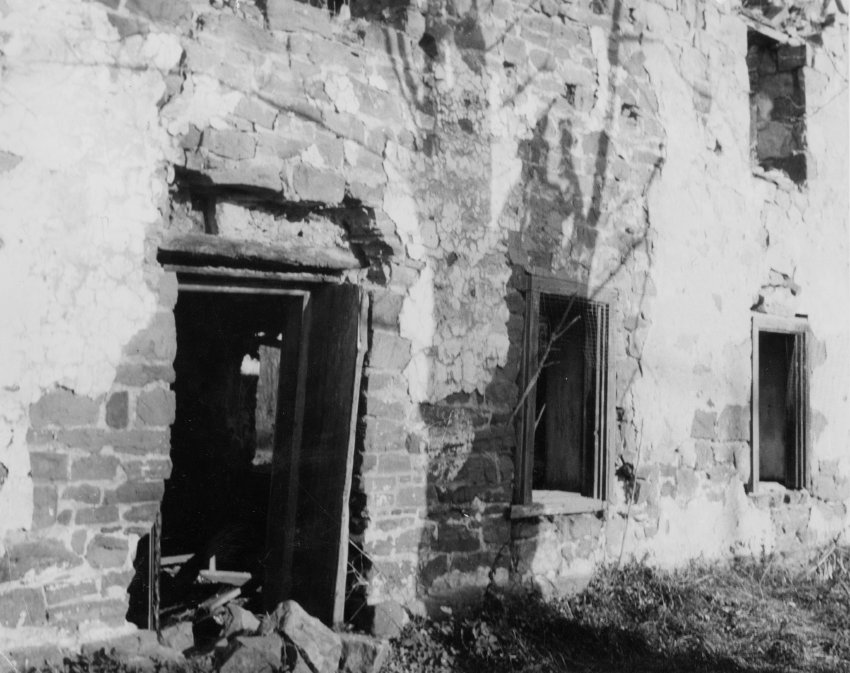
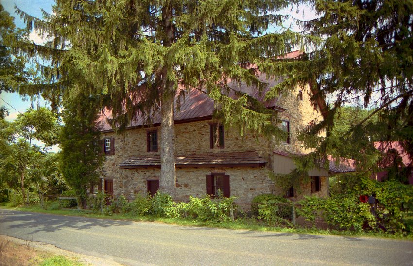
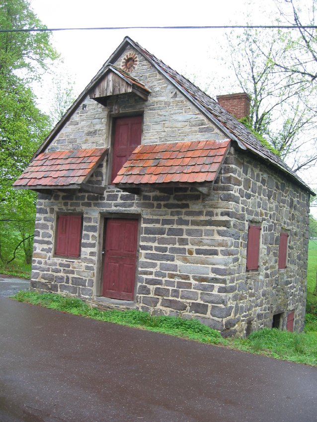
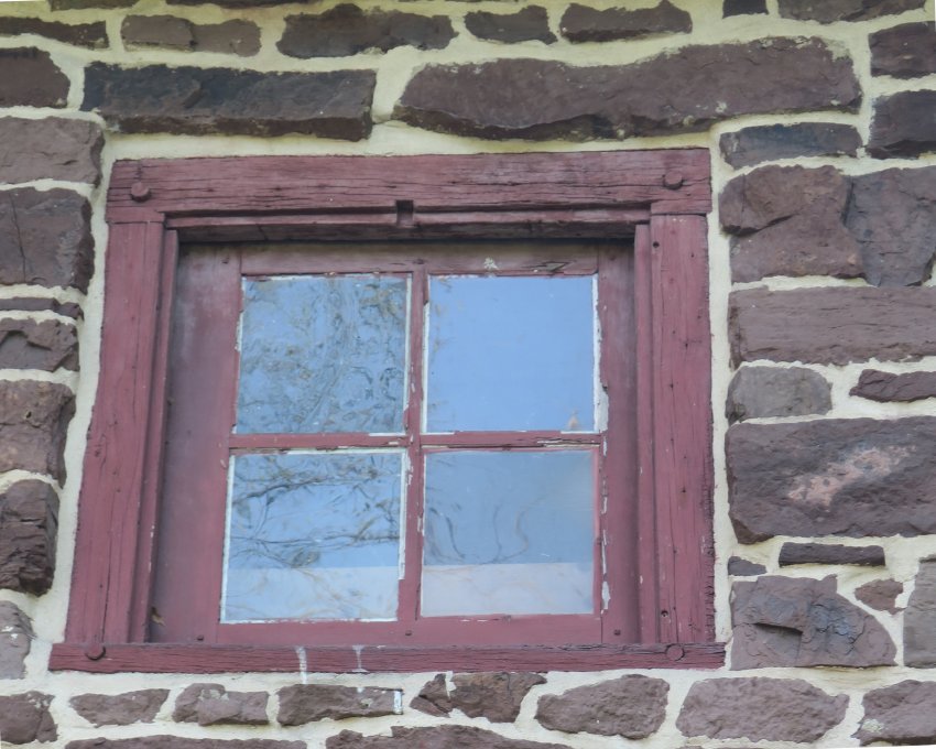
A Visit at the Hottensteins, Cover photo and pages 1-3 article in "Der Reggeboge" (The Rainbow), Quarterly of the Pennsylvania German Society, Vol. 8, No. 1, March 1974. Contains 10 Halftone images, interior and exterior, with details, from photographs, with captions. Cover photo shows Victorian porch before 1980s restoration.
View additional images or Multimedia Links for the full article.
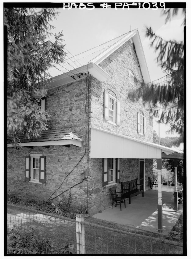
Northwest perspective view of the c. 1753 Jacob Keim house from Historic American Buildings Survey Photograph.
Description:
This view from photo, HABS PA #1039, shows: the pent roof on its original cantilevered “outlooker” supports on the northern eaves wall, with projecting “flashing course” protecting joint between shingles and house-wall [left]; the gable end segment of the 1930s roofed porch [right]; box cornice replacement of early plastered cove cornice; and brick relieving arches above windows.
Laurence Ward, February, 2021
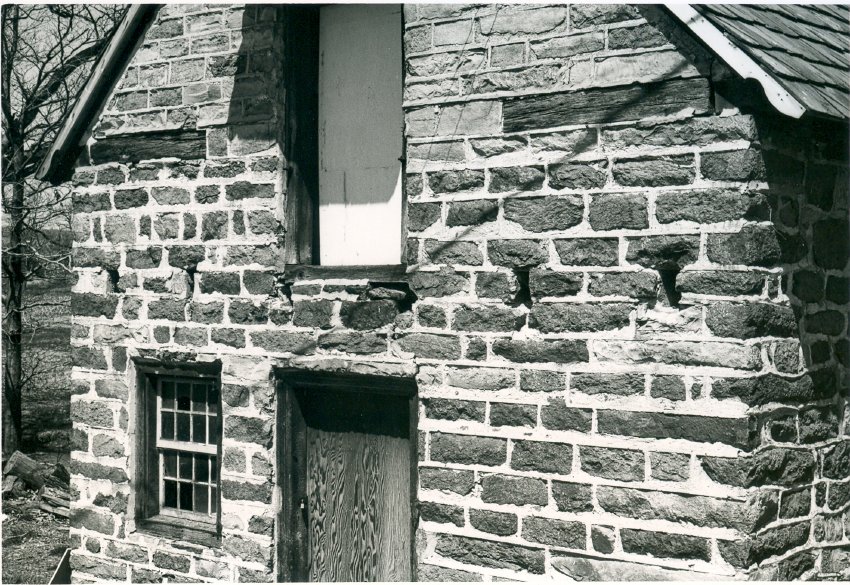
Digital image of original photograph taken by Steve Kindig. Image shows a detail view of house's south elevation without pent roofs.
Details include: outlooker remnants, coursed stone work; coursed and semi-dressed gable masonry; roughly coursed walling from plate-ties down, with pointing extruded to enhance impression of regular and rectilinear coursing
Delineated by the appearance of horizontal bed-joints, the rectangular openings in the stonework below the granary floor are the passages through the wall for the extended floor joists supporting the [missing] pent hoods, which have been replaced.
Larry Ward, updated Oct. 2022
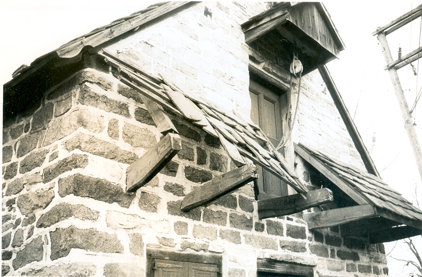
Digital image of photographic print showing damage to pent roof, clay tiles, and “outlookers” [cantilevered pent supports] caused by collision with garbage truck c.1974-1975.
Details shown in this image include: pent roof lath, rafters, damaged tiles, pedimented hood, gable pent hood, recessed-panel door, roughly coursed masonry{n}, random-rubble eaves wall masonry, rake board, granary door.
{n} to be distinguished from “ashlar”, a more formal English wall pattern laid up with blocks of uniform dimensions and more carefully dressed to provide a common vertical wall-plane [see Pottsgrove mansion and George Douglass House for nearby examples]. The DeTurk masonry employed pointing of varying thicknesses, and rough leveling to simulate authentic regular coursing. The stone units here are also minimally dressed to a common plane.
See MULTIMEDIA LINKS or additional image for reverse side of photograph
Larry Ward, updated September, 2022
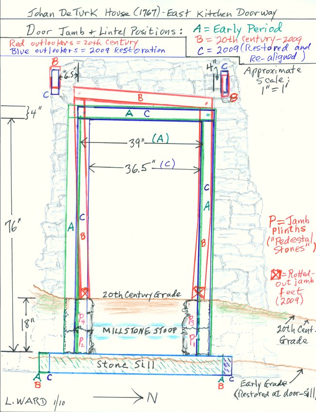
Color-keyed field drawing (8.5 x 11 inches) showing historically varying positions of door jamb, lintel, and outlookers of lower ground level kitchen doorway in east eaves wall before and after the 2009 restoration of the DeTurk House. The positions shown approximate the early (18th century), 20th-century, and post-restoration alignments of each set of elements.
Approximate scale of original drawing is 1 inch = 1 foot.
Image #2, Photo #65 shows the restored kitchen doorway and pent hood, with access from the lower grade by replaced stone steps. Image #3, Photo #3859 is a NE perspective view of the DeTurk House after restoration of the cellar-kitchen doorway, hood, and grilled cellar vent. See record DTHPH6 for vintage photos and discussion of the original kitchen door with painted folk art animals and the probable "Elbedritsche" legend-source for these mythical figures.
Digital image from photographic print showing east eaves wall. Details include: shed-form pent hood, 19th-century slate roof, south pent roof on south elevation, south gabled hood.
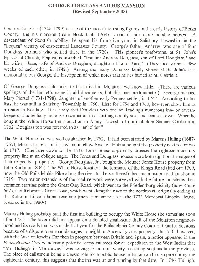
A six-page type-written history of George Douglass and his business influence in the area of current day Douglassville, PA, as well as a description of his political and business success. Text also contains various descriptions of elements of the George Douglass House, including the full-perimeter [“encircling”] plastered cove cornice, a refinement emanating from late 17th century “Baroque” English influences. This form of eaves transition appeared in Philadelphia in the very early 18th century, and within the next half-century migrated to Germantown, Chester and Montgomery counties, and eventually arose on more remote Germanic houses such as the Keim house in Berks County [see Archive record KHPH9 and the accompanying images and Footnotes].
See additional images for full text.
Larry Ward
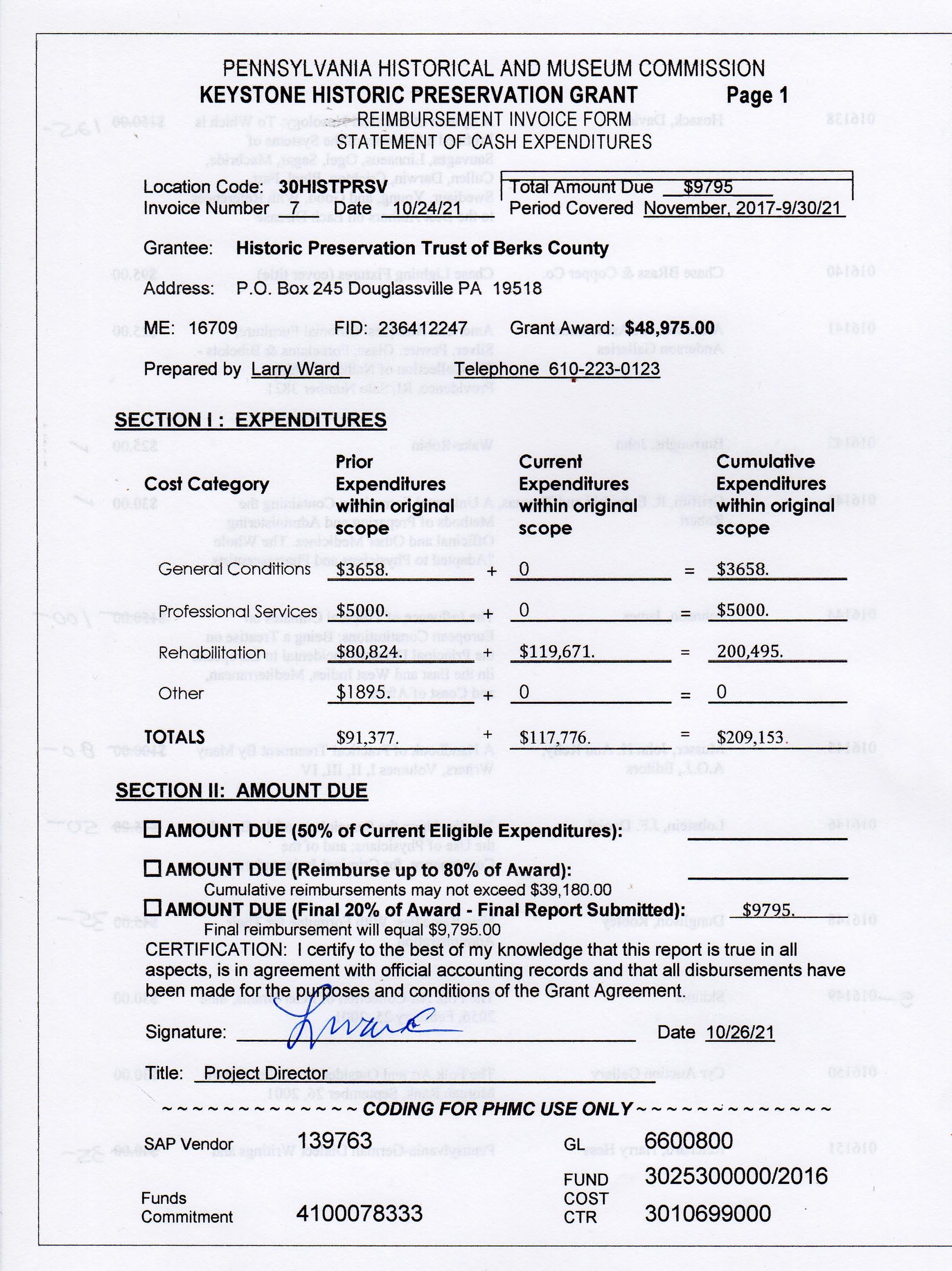
THE HISTORIC PRESERVATION TRUST OF BERKS COUNTY, PA.
Final Report On George Douglass House Restoration Project:
Pennsylvania Historical and Museum Commission Agreement ME#16709;
Project Beginning Date December 1, 2017; Ending Date September 30, 2021.
Grantee: The Historic Preservation Trust of Berks County, PA., PO Box 245, Douglassville, Pa, 19518.
Contact Person: Larry Ward, larryward59@comcast.net; phone 610 223 0123.
PROJECT SUMMARY
Scope of Work-Original:
(a) Repair, reinforcement, and restoration of deteriorated first story floor system and joist framing, consolidating sound floor boards in the two northern parlors; (b) restoration of “best” first floor parlor, including paneled fireplace surround and chimney-piece with original and recreated paneling; re-create plank, wainscot and plaster partition between parlors and between store room and kitchen; (c) Stabilize and restore original exterior plastered cove cornice and lath remaining in the original radial white oak framework; re-align and repair cornice bed and crown mouldings; (d) re-point rubble masonry behind the pent roof wall range; re-create shingled and ceiled pent roof across the southwest eaves wall façade of the original 1765 house, supported on cantilevered extensions of original 2d floor joists, covered with cedar shingles matching the house roof and ceiled with random width, beaded tongue-and-groove pine boards, and install cornice moulding and fascia; (e) Restore defective or missing plasterwork in best parlor, back parlor, store room, and kitchen.
Scope of Work Accomplished [Extra work and modifications are in Italics]:
(a) Repaired, stabilized, replaced, and/or restored first story floor boards and joist framing, including:
Extending, reinforcing, repairing, and re-leveling floor joists where necessary; modifying, shimming, supplementing, replacing, and fitting boards as necessary to achieve a reasonably regular (though not perfectly level) and secure completed floor system in the two parlors; due to the degraded and unevenly worn condition of boards surviving in the back parlor, re-purposed boards from an early house, of the same white oak species and range of widths as the originals, were used to compose the restored floor.
(b) (1) Install original and replicated woodwork in best parlor, including:
fitting original and re-fabricated joined and moulded wooden elements in both parlors including windows, box-frame, casings, architraves, and door framing, corner cupboards, fireplace surrounds, wainscot paneling, cornices, within wall intersections that are not level, true, plumb or square; painting woodwork in both parlors with scientifically determined original colors; paint touch-up will continue;
(2) re-create panel and plaster partition between parlors, including:
fabrication of an alternating-plank core wall to which the replicated hewn, or 19th sawn, wooden lath is attached;
(c) Restore original deteriorated plastered cove cornice, including:
modification of some of the original curved brackets to re-establish the common radial cove profile to receive replacement lath and plaster;
(d) (1) re-point rubble masonry range behind the (restored) pent roof, including:
re-masoning displaced stonework and re-aligning deflected flashing stone units to re-establish a reasonably true [but not perfectly level] recessed shelter for wall joint with upper shingles; re-mortaring gaps between cantilevered outlookers and masonry back-wall;
(2) re-create shingled and ceiled pent roof across the principal façade, including:
fabrication of a gabled hood over the doorway, similar to that on nearby and contemporary White Horse Tavern, also owned during the period by George Douglass;
(e) Restore defective or missing plasterwork in first floor best parlor, dining parlor, store room, and kitchen, including:
Extensive repair and structural consolidation of segments of the wood and masonry substrates for re-plastering; extensive additional masonry work included re-setting, infilling replacement stones into voids, and re-laying and re-pointing displaced and missing stones around window and doorway openings, and along wall meetings, and deteriorated segments along chair rails and baseboards; de-laminated and poorly anchored areas requiring re-plastering in the parlors were approximately twice the preliminary estimates of affected wall area; such re-plastering required a few to several coatings to bring the finish plaster to the appropriate surface plane, allowing time for each coating to cure; extra work to repair or replace and re-attach wooden lath included applying re-cycled hewn lath where original pieces were missing or unsalvageable, and using 19th century sawn lath for new plaster on the partitions, and re-nailing or screwing deflected or delaminated lath to floor joists or other attachment members. Far more plaster was defective and required replacement than was apparent from surface inspection. Whitewashing, not part of project scope but partially applied within project timetable to stable re-plastered and earlier surfaces, will progress on other wall segments after documentation of building history on remaining plaster surfaces [e.g., shelving “ghosts” on plaster in 18th century Amity store-room], and deferred for some surfaces [discolored areas in photos] to allow adequate curing time for patches and infilled areas. 2d floor plaster was repaired and cracks and voids consolidated with replacement plaster where defective; sub-strate and plaster integrity were restored on all walls and ceilings as on first floor walls and ceilings. .
PROJECT BUDGET
Estimated Budget and Final Budget as expended, including Changes and Extras:
General Conditions, Equipment Rental, set up: Estimated… $3,658. Final… $3,658.
Professional Services, Estimated $3500. Final expenditures $5000.
Wood Carpentry, Joinery, Flooring: Estimated… $62,770.
Paint Finishes, plaster repair and replacement: Estimated… $29,680. Final plastering expenditures $115,808. NOTE: Final expenditures included work not within the original scope of project, including 2d floor plastering and sub-strate restoration on both floors.
Total Original Budget Estimated… $97,950.
Total Final Budget Expended… $209,153
NOTE: Extra plastering and off-scope structural and fabric stabilization and other work not included in the original specifications were funded with-non grant and non-match sources.
PHOTOGRAPHS ATTACHED
Views of principal façade before and after restoration of pent roof and plastered cove cornice.
View of 1760s Amity Store room after restoration of corner cupboard with original colors, structural stabilization of sub-strates, re-plastering, and re-fabrication of kitchen partition [right of cupboard].
Views of parlors before and after restoration of plaster and milled and joined woodwork, and re-fabrication of partition re-separating back parlor.
Views of kitchen before and after wall and ceiling plaster restoration and floor stabilization.
Larry Ward
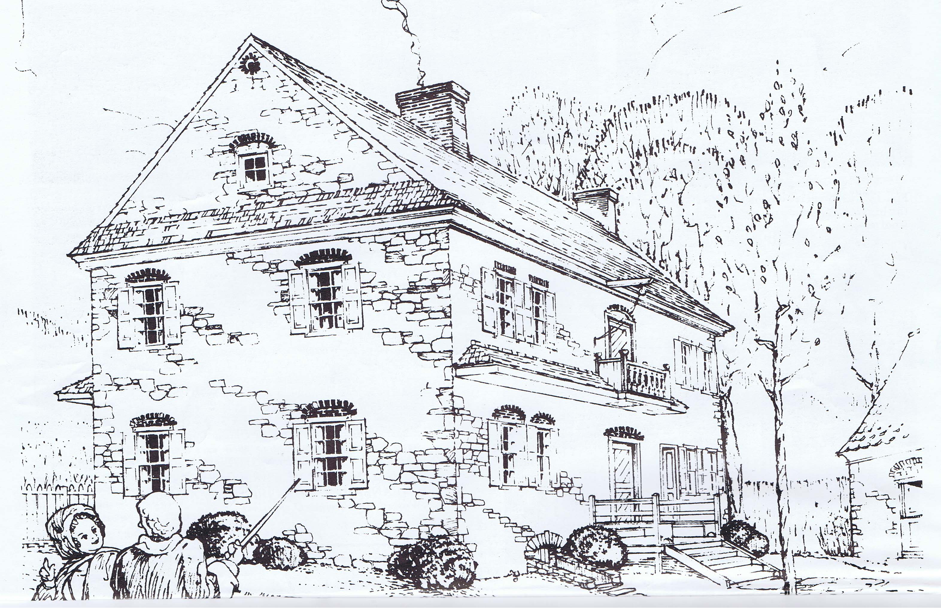
Perspective drawing of the Jacob Keim “Manor House” from the southwest, published in the copyrighted April, 1975 issue of “American Folklife, A Monthly Newspaper Devoted to the American Culture”. This image and the text excerpts are published here with the generous permission of Richard Shaner, Publisher, Managing Editor, and principal contributor to the essays and captions of "American Folklife."
In the text accompanying this rendering, Mr. Shaner observed that “A colonial balcony on the south side of the Keim Manor was altered when the home was given a huge porch which currently covers two sides of the manor. Upon investigation the staff discovered that the old porch ceiling still contained the original out riders to the colonial balcony…. Also incorporated in the porch roof line on the south side was an original out rider for the colonial pent which joined the balcony. This out rider gave…the exact measurement for the depth of the original colonial pents and an idea of their pitch.”
The perspective of this rendering suggests a symmetry in the façade that did not exist in the main elevation of the original 1753 house. The added bays to the east [right] of the door and balcony date to about 1800. The originally asymmetrical placement of the door in the east end-bay resulted in a “side-passage” alignment of the kitchen entry and second story balcony. Most of the antecedent and contemporary houses with a balcony were central-passage “Pennsylvania-Georgian” types such as “Grumblethorpe” in Germantown [Lithographic perspective view in "Quaint Old Germantown," Plate VIII], the Peter Wentz house in Worcester Township and Muhlenberg Houses in Trappe (both in Montgomery County), and “Bellaire” in Philadelphia [see "Worldly Goods," p. 84, and Kornwolf, Vol. two, p. 1223]. All houses cited except Wentz currently display a balcony surround of neo-classical turned balusters and molded handrail; Wentz’ rendering is scroll-sawn “splat” form, apparently based on the choir-railing at Trappe Lutheran Church.
The Keims were wood turners by trade, producing lathe-turned spindles and possibly balusters in the nearby and contemporaneous workshop structure southeeast of the house. Nonetheless, the vernacular Georgian houses cited above, with centrally-aligned balconies with turned balusters, would not seem to provide compelling templates for re-producing a balcony for the decidedly Germanic, asymmetric, and uncoursed masonry façade of the Keim house. Currently under consideration is a plain or edge-beaded board form, as suggested by a board railing on the second floor of the house.
The porch on the west gable wall and south eaves wall mentioned in this article was almost certainly added in the 1930s, based on photographs and analysis in record KR11PH3 [see photos and accompanying text in archive records KHPH8--1002.01.027, KHPH9--1002.01.044 & KHPH13--1002.01.057], and is without historical precedent as to form or appropriate scale with respect to the earliest bays of the house. The intermediate porch [see KHPH9--1002.01.044]--probably constructed circa mid-nineteenth century after disintegration or removal of the original pent roof--did not wrap around the corner or extend across the gable wall. Neither porch roof tucks closely under the projecting stone flashing course, which therefore does not effectively protect the joint between the porch roof and the masonry wall from moisture infiltration, as it did for the original pent roof [see pent on road-front (north) eaves wall, which provides a virtual template for the proposed pent roof on the south eaves wall].
Other period or recreated early details rendered in this drawing include: central chimney on original bays; gable-end chimney on early addition [right bays]; pent eaves on west gable; pent roof on south eaves wall; second storey “colonial balcony”; brick oculus vent in west gable apex; brick relieving arches; western corner of original pent roof on north eaves wall; stone-arched cellar entry; northwest corner of 18th-century ancillary building [right edge of drawing].
See KHTX2--1002.01.021 for the full text printed below this drawing reproduced on page 12 of the issue cited.
Archive record KHTX8--1002.01.048 is the text accompanying a conceptual northwest perspective drawing of the original manor house by Gerald O’Brian, rendered without the early eastern addition, and published on page 12 of the April, 1974 issue of Richard Shaner’s “American Folklife.”
Laurence Ward, Updated 2020
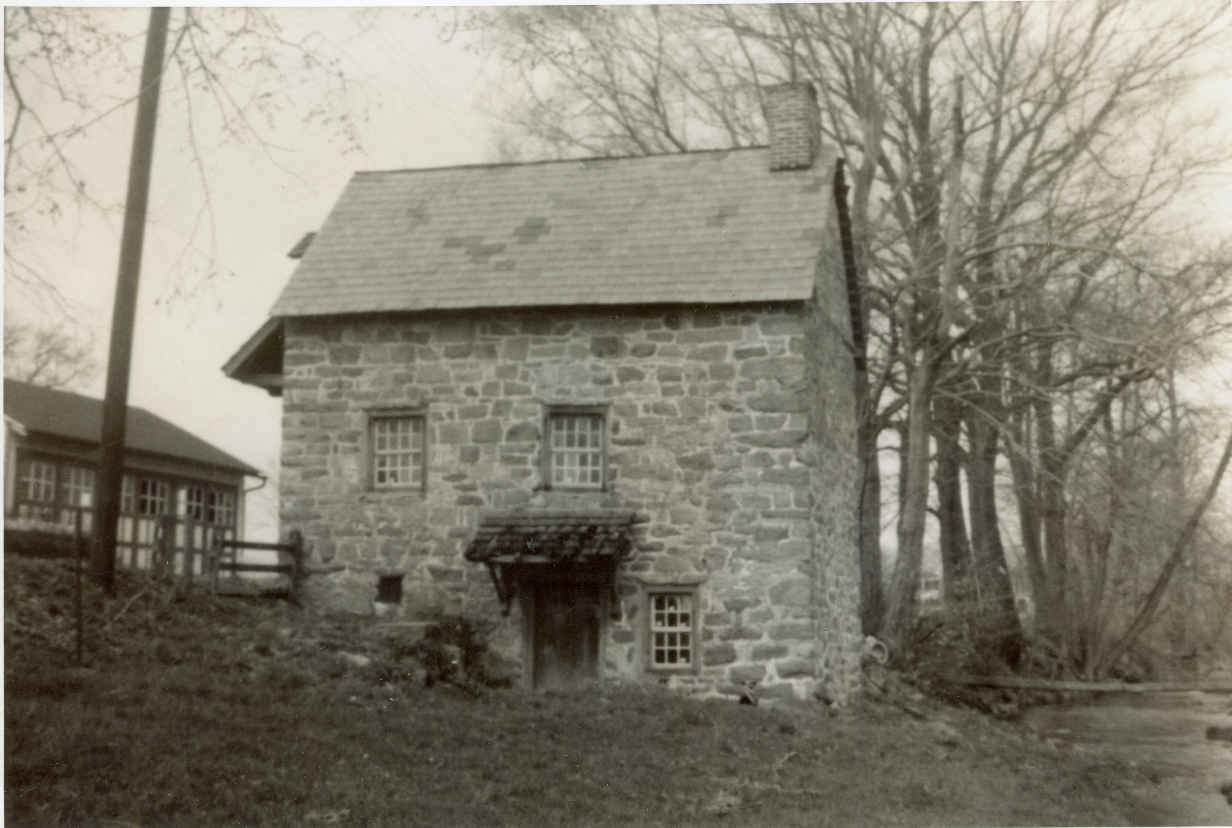
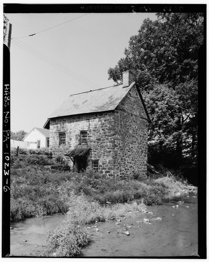
Series of 3 digital images from photographic prints showing NE perspective view of DeTurk House, showing the Little Manatawny Creek; images 4 & 5 show details discussed below.
Image#1 details include: 20th-century braced clay-tile roofed pent hood over lower-level kitchen door, 19th-century slate roof [replaced with clay tiles in the 1970s], gable-end chimney, horizontal timber plates ["plate ties"; "spreader plates"] at the eaves line, iron tie rod [removed between 1941 and 1958 and replaced with two interior rods; see DTR09PH104--1001.01.200 & DTR09PH105--1001.01.201] across north gable connecting wall plates as reciprocal restraints against roof thrust.
Original HABS caption for image #1 is as follows:
GENERAL VIEW OF DE TURCK HOUSE, BUILT IN 1767. ("Johannes and Deborah de Turk 1767" is carved over door)
Images #2 & 3, published here with the generous permission of the Historical Society of the Cocalico Valley, Ephrata, Pennsylvania, are digital copies of photographs taken on May 9, 1954 by Harry Franklin Stauffer (1896-1979), self-labeled and highly proficient "Printer and Tinker" [and accomplished architectural and landscape photographer] of Farmersville, Lancaster County, PA. The photographer captioned these images in part as showing the John DeTurk "Stone spring house/speicher" from across the [Little Manatawny] Creek. Stauffer also observed that the 1741 "main house was log and stood at left of garage," apparently unaware that the 1741 stone house, famous as the probable site of Zinzendorf’s "ecumenical" synod{a}, had been integrated into the expanded stone farmhouse which stands today just across DeTurk Lane from the multi-purpose 1767 farmstead structure shown in these photographs.
The details depicted in images #2 & #3 include: iron tie-rod [probably late 19th or early 20th century] connecting wall plates across the north gable; damaged slate roof; long roughly vertical fracture in eastern segment of the north gable wall; and deflected first floor window [right]. The last three disrupted sites are consistent with other evidence{b} of one or more "tectonic" events deforming structural components near the northeast corner of the building.
Images #4 & 5, both c. 1950 in blue-tone, similar to other “cyanotypes” taken and printed by Stauffer, show that the pent roof over the kitchen cellar doorway was covered with early clay tiles. The main roof is 19th century slate.
{a} Discussed in records DTHPH32--1001.01.060 & DTHPH48--1001.01.037 and on page 113 of "Oley Valley Heritage, The Colonial Years: 1700-1775," wrtitten by Philip Pendleton, published by The Pennsylvania German Society and The Oley Valley Heritage Association (1994).
{b} transverse fracture in sill at lower level kitchen door, dislocation of cornerstones in fireplace pier, torsion rotation of lower level kitchen window in east wall, and a significant deflection of the fireplace lintel at its bearing location in the west wall of the kitchen (see record DTR09PH138--1001.01.244).
Laurence Ward, 2010, updated April, 2021, September 2022.
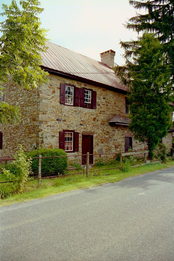
Frame # 13 of 16 (2-17) from 35mm color negatives, all various views of the buildings on the Jacob Keim Farmstead.
Northeast perspective view of Keim house with unceiled pent roof [with original framing] on north eaves wall [right third of photo]. Other details include: non-period chevron-pattern Dutch door in original (western) bays [right third of photo], capped and parged chimney, later standing seam roof [see KHPH13--1002.01.057 for possible evidence of clay-tile roof on main roof in late 19th and/or early 20th century], alternating “quoin” stone corner pier. Left two bays [door and three windows] define early addition.
Laurence Ward, updated March 2021
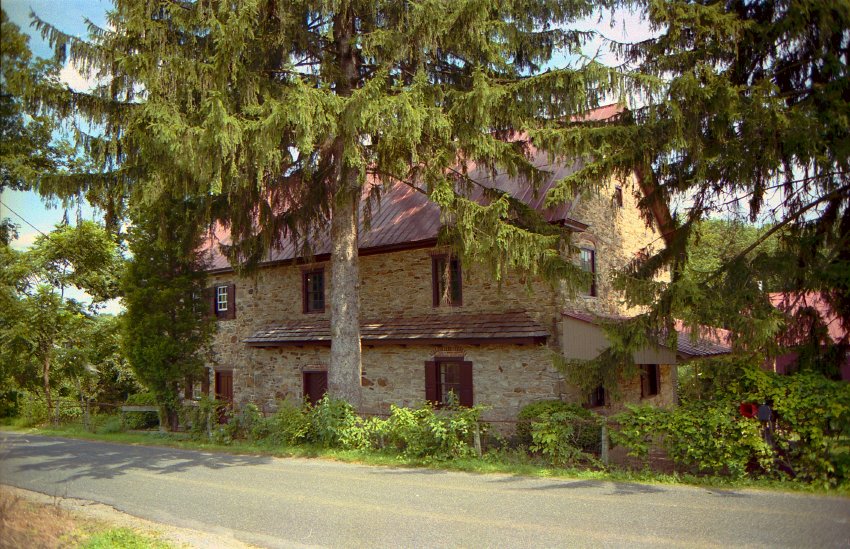
Image #1, Frame # 10 of 16 (2-17) from 35mm color negatives, all various views of the buildings on the Jacob Keim Farmstead.
Northwest perspective view of Keim house with 20th-century Victorian-style porch on gable end [SEE KHPH13--1002.01.057, and KHPH9--1002.01.044, showing the west gable wall in the late 19th century and very early 20th century without a porch]. Details include: unceiled pent roof [with original framing] across north eaves wall.
The framing of the cantilevered ["outlooker"] supports for the "pent" indicates that this support structure, mortised into and borne by the wall masonry, is original to the 1753 construction period of the house. A c. 1897 photograph seems to show the pent, an extremely effective means of sheltering window and door woodwork from moisture invasion for decades (sometimes centuries), in the same alignment and range as in the 1990 photograph [Image #2, Photo KH4, 10/17/10]. This photo also shows that the existing porch on the west gable end did not exist in 1897 [or in 1929-30, according to the Amandus Moyer photo posted in record KR11PH3].
Laurence Ward, January, 2021
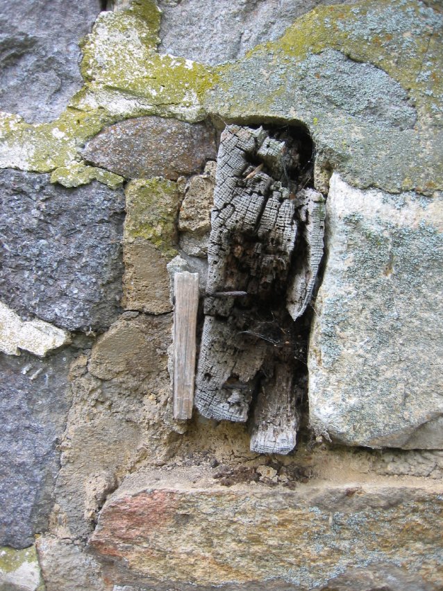
The rotted end-grain of the timber in the center of the photo is the cut-off remains of the southern outlooker, one of the pair of cantilevered supports for the original 18th century and the restored 20th-century pent hood over the kitchen doorway in the east eaves wall [see DTR09FN3--1001.01.176 for a sketch drawing of the various positions of the door frame from the early period to modern times, including the 2009 restoration]. The wooden shim nailed to the side of the outlooker is not an original detail.
Laurence Ward, 2010, updated April, 2021
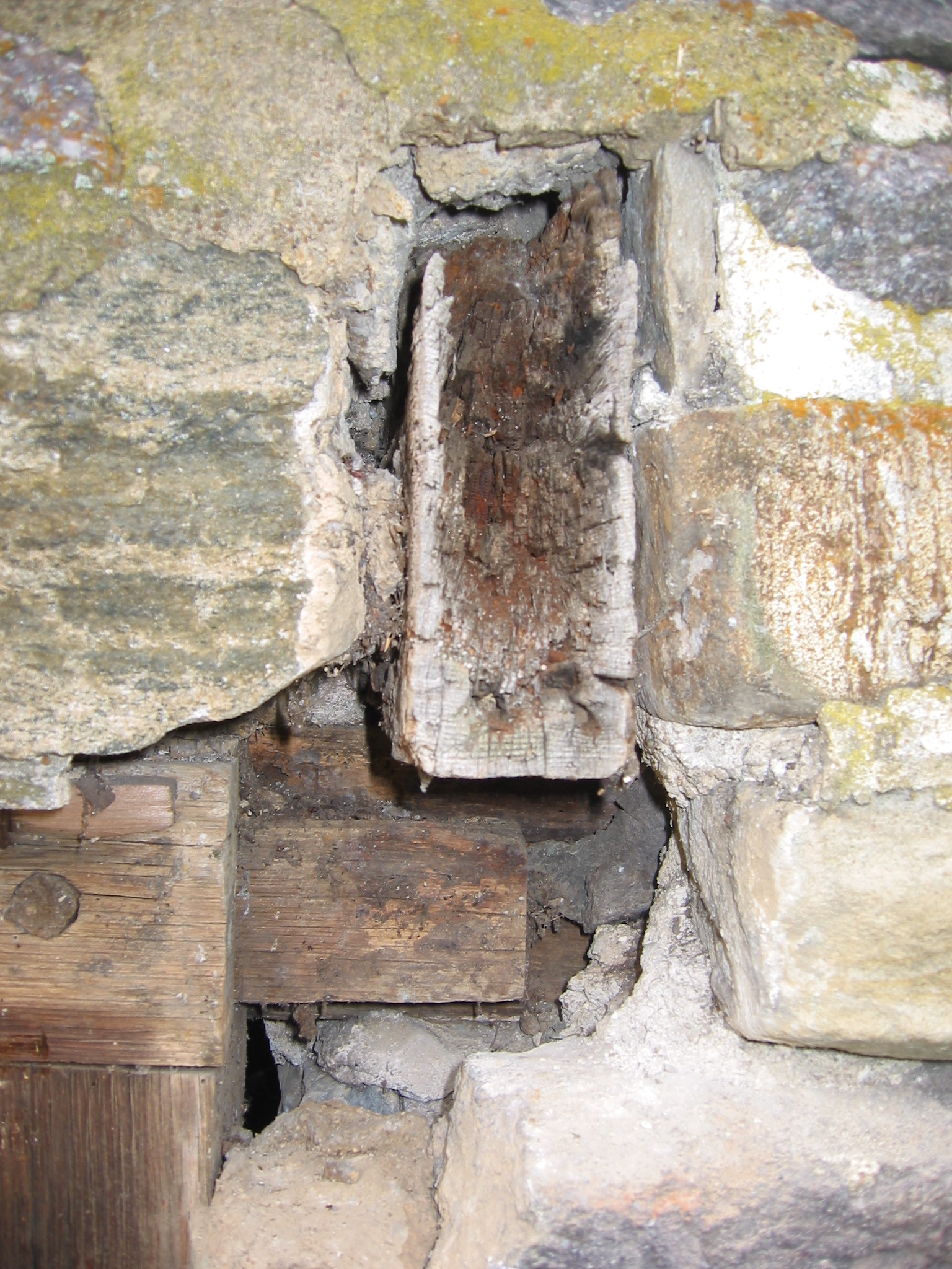
The rotted end-grain of the timber in the center of the photo is the cut-off remains of the northern outlooker, one of the pair of cantilevered supports for the original 18th century and the restored 20th-century pent hood over the kitchen doorway in the east eaves wall. Just below and to the left of the outlooker fragment is the northern tenon [“ear”] which emerges from the pegged corner-joint of the door-frame lintel in its 20th-century location. The original lintel was 4 inches lower, and its tenon was pocketed in the masonry abutment; the “pocket” and some of the mortar in-fill are visible below the tenon. The replacement lintel will be secured to the abutting masonry at the original elevation and the tenon inserted into the original pocket [see DTR09FN3 --1001.01.176 for a sketch drawing of the various positions of the door frame from the early period to modern times, including the 2009 restoration].
Laurence Ward, 2010, updated April, 2021
Series of 19 images showing perspective views of the Keim House and other dwellings, detail views depicting evidence of an early plastered cove cornice on the Keim house, and other related photos, including images of houses built during the same quarter-century period as the Keim house and earlier English antecedents displaying plastered cove cornices.
Image #1, an early 20th century view, appears to show deteriorated remnants of a coved plaster{a} cornice under the second story eaves of the 1753 house [left of roof extension above the second story balcony], and on the c. 1805 addition [right of roof extension]. Images #2, 3, and 4 are colored digital images provided by restoration craftsmen and consultants Tom and Chris Lainhoff, showing coved oak joist-ends{b} with nail holes for lath, confirming that an early plastered cove cornice existed, most probably from the first period of the 1753 house. This conclusion is reinforced by the un-coursed "rubble" masonry walling behind the cornice [Images #3, #4, & #5]. Such coarse stonework would not be seen behind the plaster and lath of the cornice and is therefore not masoned as methodically as the visible wall ranges of the house. As a comparison and contrast of masonry methods on the same building, the wall ranges behind each Keim house "pent" were as carefully laid-up as all other exposed ranges of the structure because the pent roofs were not ceiled {c}.
{a} In modern usage, "plaster" ("plaister" in early British terminology), is sometimes confined to interior finishes, and "stucco" is limited to lime-based rendering applied directly to exterior wall surfaces. Early plaster was extruded ["keyed"] between wooden lath, originally riven [sometimes "hewn"], and later sawn, for anchorage.
Some scholars consider the interior-"plaster"/exterior-"stucco" distinction to be arbitrary and historically unwarranted [see Curl, A Dictionary of Architecture, Oxford U. Press (1999), page 645]. Other respected authorities seem to prefer "plaster" in describing interior renderings, invoking the earlier term "roughcast" for coarsely aggregated exterior coatings [e.g., Lounsbury, Carl, Editor, An Illustrated Glossary of Early Southern Architecture and Landscape, page 279]. In the context of Mid-Atlantic vernacular building forms and practices, the highly regarded authors noted that "Stucco…[was] sometimes applied to interior walls…(though more commonly to describe an exterior finish)" [Lanier & Herman, Everyday Architecture of the Mid-Atlantic…Buildings and Landscapes, Johns Hopkins University Press (1997), p. 113]. The legendary Renaissance stone mason and architect Andrea Palladio invoked the term "stucco" to describe the decorative plaster coating applied to interior niches in his villas.
Other scholarly textual sources uniformly describe cornices as "plastered" when specifying the material applied to exterior coved eaves transitions (e.g., Richie, Kornwolf, Murtagh, Schiffer, Tinkcom & Simon). It is clear that there is no consensus among the academic community endorsing the use of the terms "plaster" and "stucco" based merely on interior or exterior applications.
{b} Compare the lath-nailing system of the George Douglass house, where concave brackets are suspended from the sides of the cantilevered attic-floor joists [see Image #6] projecting beyond the top of the rubble segment of the wall, and are footed on the projecting upper surface of the squared and dressed sandstone blocks forming the top course of the "ashlar" façade. [Image #6, photo "GD cove brackets 2", 8/23/13]. Images #7 & #8, Photos 2950 and 2951, 7/12/13 show surviving plaster fragments of the early cove cornice on the Douglass house [Images #9 & #17]. The convex view in Image #7 clearly shows the thin plaster "keys" which extruded through the narrow gaps between lath, securing the finished cornice in the coved profile established by the brackets.
{c} earlier: "sealed", typically with board sheathing.
The nail holes in the coved joist-ends of the c. 1805 addition to the 1753 Keim house are spaced differently from those on the early house, indicating that the two cornices, though approximately conformed in dimension and cove radius, were applied in different periods, probably separated chronologically by the approximately half century between the 1753 house and the Federal-era addition project. Therefore, the two cornice segments, though jointed in some manner when the addition's cornice was plastered, never formed a monolithic concave band across the contiguous eaves of the two house-blocks. Unless the cornices were re-plastered contemporaneously in a later period [of which there is no evidence], they were never unified in a single plastering campaign. The current [2013] restoration program relates only to the 1753 house, including its cornice. The coved plaster cornice on the c. 1805-10 addition will be considered for a future restoration campaign.
One of the earliest cove cornices in the Philadelphia region appeared on the three bay pre-Georgian Anglo-Pennsylvania Chalkley [Letitia Street] house (c. 1703-1715; see Tatum, Penn's Great Town, plate 6, and Fig. 2 in Smith, Two centuries of Philadelphia Architecture, 1700-1900, offprint, pp. 291-303, from Transactions of the American Philosophical Society, New Series, vol. 43, Part 1, March, 1953, which describes the cornice as constructed of wood), built in central Philadelphia and since 1883 situated on its re-located site in Fairmount Park. Smith's "Two Centuries" paper notes in footnote 6, p. 290, "three houses with pent roof and cove cornice"…[on] Cuthbert Street in Philadelphia.
Another early Philadelphia house with a cove cornice, "that would become so typical of the Delaware Valley" [Kornwolf, Architecture and Town Planning in Colonial North America, Vol. Two, p. 1223], is the surviving two story, five-bay "Bellaire", c. 1714-1729, an early Georgian plan-form with English Baroque decorative elements, and built for the prominent Quaker Mayor of Philadelphia and Provincial Treasurer, Samuel Preston [see Worldly Goods, p. 84, Phila. Museum of Art, 1999].
The "High Street" [2d and Market] "Greater" Meeting House, built c. 1695 and re-built in 1755, and the old Court House/Town Hall across the street from it, also featured full-perimeter ["encircling"] coved and plastered eaves cornices in their early periods [see Tatum, op cit., plate 8].
A five-bay brick house, the 1730 William Miller house in Avondale, Chester County, PA, prominently boasts another "encircling" plastered cove cornice, added at the attic floor level when the third story was erected in 1771 [Schiffer, Survey of Chester County, Pennsylvania, Architecture, 17th, 18th and 19th Centuries, page 61, Image # 19, photo miller cove cornice]. It is not clear whether a cove cornice appeared on the first-period house at the original 2d story eaves level.
Another four-range cove cornice, restored in 1950, appears on Wright's Ferry Mansion, Columbia, Lancaster County, PA, built in 1738 with roughly coursed limestone "rubble" and hybridized by some Germanic details for the Quaker "Renaissance woman" Susannah Wright.
Yet another Quaker structure with a most imposing surrounding cornice, described as a "concave, plastered support," above roughly coursed rubble walls and segmental brick "relieving" arches, is the 1768-1769 Buckingham Friends Meeting House in Bucks County, PA [see photo and caption at pp. 64-65 of Stone Houses… Bucks County and Brandywine Valley by Richie, Milner, and Huber (2005)].
It seems reasonable to infer from the early Philadelphia-area examples cited, (and some in West Jersey) that immigrant plasterers from England, who probably received training and experience in the post-fire English Baroque tradition{d}, would have been familiar with and probably influenced by 16th and 17th century specimens of prominent plastered coved cornices in their homeland. Such traditions would have been preserved and transmitted within the British building trades within the prevailing and ancient master-journeyman-apprentice system under the auspices of craft Guilds devoted to the "art and mystery" [craft methods and trade secrets] of each artisan group. Plastered cove cornices, some on half-timbered town-houses with curvilinear plastered eaves-panels, appear on substantial houses in 16th and 17th century England. Examples would include half-timbered 16th century structures Congleton, and Moreton Old Hall, both in Chesire, and a dormered three and a half story Town House in Bisley Street, Painswick, and the symmetrical three-bay pre-Georgian house in Lechlade, also in Gloucestershire. These antecedents, graciously brought to the Trust's attention through the scholarship of Joe Kindig III of York County, would have provided an abundance of prototypes for emigrant plasterers re-settling in Penn's distant colony, and their protégés. Examples from the late half-timber period appear in photographs published in British Bouquet, An Epicurean Tour of Britain (1963) by noted architectural photographer and etcher Samuel Chamberlain [images #10, 11, and 12].
{d} This tradition included numerous variants and applications, in architecture and decorative arts, of the "C-scroll" motif and the Renaissance (originally Roman) versions of the "cavetto" moulding profile.
The National Register application on behalf of the c. 1698-1700 Reynolds house in Bristol, RI describes "an original plaster cove cornice" as "a rare survivor following late seventeenth century English precedents". Several plastered cove cornices in New England and the southern tier of the mid-Atlantic states are recorded in HABS and National Register records.
An impressive concentration of houses with coved lath-and-plaster cornices, some with shed-form roofs ["pent eaves"] across the gable walls and most constructed in the 1740s, appeared in German Township, later the Germantown wards of northern Philadelphia but then an independent community established by a Penn grant 10 miles north of Philadelphia in the late 17th century. Notable among these are the earlier (of two) Gorgas ("Monastery") house, 1746-47 [see image #13, photo #gorgas], and the earlier (of two) Daniel Pastorius house [1748, image #14, photo #3402], later known as the Green Tree Inn. Other mid-18th-century stone houses in Germantown with plastered cove cornices include the early 18th-century De La Plaine house [demolished 1885], which was gambrel-roofed and dormered (wounded Civil War veteran John Richard's lithographic Plate X); and the (Van Lauchet) Weygandt house (Richard's Plate XXX , also gambrel-roofed, with an asymmetric street façade. Plate XLVI also suggests a coved cornice on the dormered section of the house on Thorp's Lane, near the site of Weber's and Thorp's Mill. Richard's detailed drawings were published as lithographic reproductions by the Pennsylvania German Society in Vol. XXIII of its "Proceedings", Lancaster (1915), in the essay and plate collection called "Quaint Old Germantown."
The design currents and craft proficiencies producing the coved plaster cornices in the Philadelphia region in the earliest decades of the 18th century reached Germantown by 1740, and appeared in more remote northerly settlements by the middle of the 18th century, as exemplified by the cornices at Pottsgrove [1752], Keim [1753], Eshelman [Lancaster County, 1759], Abraham Landis [Lancaster County, 1763], and George Douglass [Amity Township, Berks County, 1765].
The most prominent "backcountry" house with plastered cove-profile cornices (and an English Baroque-influence re-constructed door-hood) is John Potts' "Pottsgrove" mansion [image #15, photo #265, 9/11/12], built a year or two before the Jacob Keim house, and about 12 years prior to the 1765 George Douglass house, which displays a cornice quite probably influenced by Pottsgrove, though in a more attenuated and vernacular interpretation of this and other design details. The Pottsgrove cornice is plastered on lath nailed to coved brackets scribed and "sistered" to the coved ends of the attic floor joists projected through the top courses of the walls. This system and its lath nailing pattern for the early plaster cornice, differing from the coved joists at the Keim house and the suspended brackets at the George Douglass house, can be viewed at Pottsgrove via a strategically placed mirror through a window in a second floor chamber, as the brackets and a coved plaster segment are now sheltered by the "ell" addition constructed c. 1820 and butted against the original 1752 house.
This group of houses--Pottsgrove, Douglass, and the earlier Germantown structures--all feature coved cornices framed by crown and bed mouldings above a coursed and dressed "Georgian" façade. The Keim house departs from this essentially Pennsylvania-Georgian design approach, lacking the evenly coursed ashlar block-work and central passage façade-symmetry of most of the other houses cited. The 1753 Keim house also apparently omitted a traditionally moulded "crown" piece forming the outer (and upper) termination of the plaster cove. The restored top trim board will be beaded and finished with a chamfered "drip-edge."
A slightly later (c.1768) pre-Revolution structure with several design details in common with the Keim house is the Bethlehem Widow's house depicted as plate 45 in Murtagh, Moravian Architecture and Town Planning, p. 87, and Brumbaugh, Colonial Architecture of the Pennsylvania Germans, plates 76 and 79 [captioned "Moravian Seminary"]. Although the Widow's House is laid-up in courses, is symmetrical on its principal elevation, and is dormered, both it and the Keim house (as well as the Buckingham Meeting House cited above) "relieve" the rectilinear geometry of their fenestration openings with segmental brick arches, and refine their eaves transitions with coved plaster cornices arcing between bed- and crown-mouldings.
The 1753 Keim house is undoubtedly one of the few random rubble structures in the region (perhaps a unique example) with a three-room Germanic floor plan, asymmetric eaves-wall fenestration, a coved plaster eaves cornice, a stone-arched cellar doorway, and a cantilevered balcony [to be reconstructed] above the end-bay ["side-passage"] doorway.
Two Lancaster County Germanic-Georgian houses with mixed characteristics and "encircling" coved plaster eaves cornices are:
A. the 1759 house in Conestoga Township, Lancaster County, PA constructed for Mennonites Benedict and Anna (Stehman) Eshelman [cfr. photo and floor plan in Falk, Architecture and Artifacts of the Pennsylvania Germans (2008), pp. 144-145]. Unlike the Keim House's emblematic three-chamber stove room ["stube"] plan, the Eshelman house includes a slightly off-center walled passage and rear stair-hall, and four rooms on the first floor, the larger pair (kitchen and stove-room) to the left of the hallway. The Eshelman façade is laid up in coursed and roughly dressed block-work and a full perimeter rubble course between first and second story windows, indicating that an early ceiled pent roof had been removed, an inference further affirmed by a projecting flashing course and outlooker remnants, apparently truncated when the pent was removed; and
B. The Abraham Landis house in East Lampeter Township, c. 1763 [Lestz, Lancaster County Architecture, 1700-1850, p. 54, photo].
Other Keim House Details include: 19th-century roofed porch [Image #1], replaced by the "L" form two range porch in the 1930s; second floor balcony [to be re-constructed in 2013-14], framed onto cantilevered "outlookers"; flashing ("drip") course for earlier pent roof (removed, presumably to make way for the porch roof shown in this record).
Note the absence of porch or evidence for porch on west gable wall; the L-form 20th-century porch succeeding this one is depicted in record KPH4--1002.01.009. A history of this 19th century porch and its 1930s successor, removed in 2011, and related photographs and other images appears in archive record KR11PH3--1002.01.092.
The vertical separation between the "flashing" course (which sheltered the joint between the original pent roof and the eaves wall) and the top of the porch roof shingles in these "vintage" photos appears to have been approximately 12-14 inches. With this separation, the flashing course did little to prevent precipitation from penetrating the joint between the pent roof and eaves wall, gradually and inevitably eroding or rotting the rafters and lathing of the porch roof. Signs of such decay were evident on removal of the early 20th century porch rafters and other framing members.
Laurence Ward, 2011; updated February, 2021
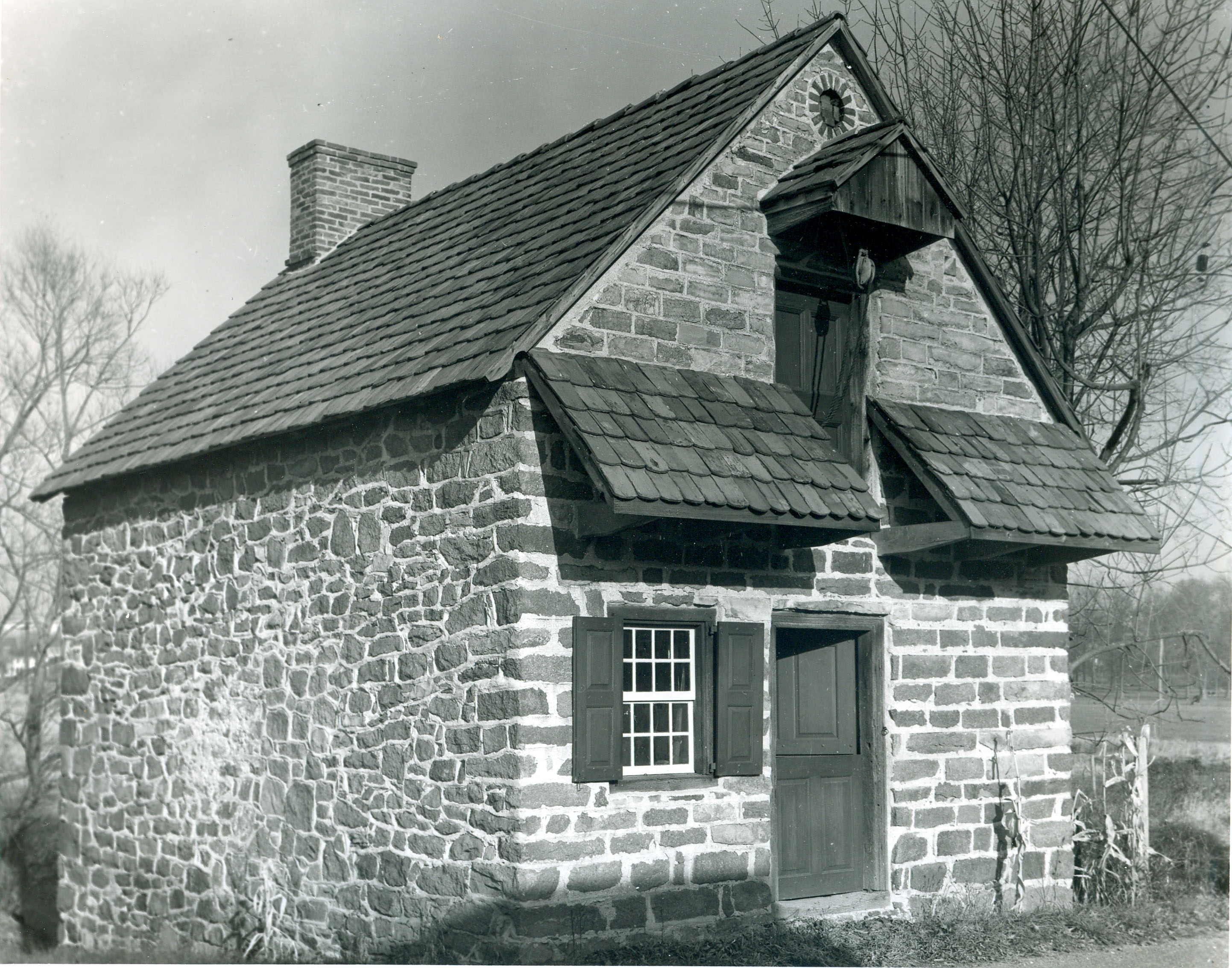
Digital image from a photographic print showing southwest perspective view.
Details include: gable-end chimney, roof restored with early clay tiles, oculus vent, gable hood, replicated attic door, replicated shed-form pent roof and outlookers, replicated Dutch door, eight-over-eight window and replicated shutters, coursed masonry gable-end wall, random rubble masonry west eaves wall.
See MULTIMEDIA LINKS or additional image for view of reverse of photo.
Larry Ward, 2016
Series of 13 images (4 black & white photographic prints, 5 color digital images, one HABS data sheet, and one field notes elevation drawing) showing details of the west [river-side] elevation of the Mouns Jones House. Additional images illustrate similar houses and architectural details described in the text references to those images.
Details include:
A. Board-sheathed 19th-century doorway in north bay [color images show doorway appearance after removal of sheathing, and after 1960s reframing of doorway]
B. Modified fenestration, casement and hung-sash variations
C. Images #1 & #7 show remnants of pargeted masonry walls, and sockets cut into masonry and window sill for 19th-century porch rafters; note written in pencil on verso of Image #1 reads, "MJ--elevation detail (c.1965)"
D. Image #4 shows the present elevation as interpreted in the 1965-70 reconstruction
E. Image #5 shows a possible restoration of the original façade, with a re-centered doorway; fenestration format is hypothetical, except that the second story window in the north [left] bay is based on the 1886 woodcut and pre-1966 photos. In 2015, the size and proportions of the window openings in this elevation was re-considered, based on evidence from surviving window frame elements and 20th century photographs [see record #MJHPH102].
F. Image #6 is the hypothetically restored view from the western banks of the Schuylkill River
G. Image #7 is a c. 1957-1965 detail view of the west eaves wall from a southwest perspective; H. Image #8 is a 1958 newsprint halftone detail view of the west eaves wall from a southwest perspective;
I. Image #9 is a c. 1958-64 NW perspective view taken after the c. 1957-58 roof collapse;
J. Image #10 is a 1985 digital copy of Barry Stover’s pencil Field Notes drawing of the western elevation, showing dimensions and framing annotations;
K. Image #11 is a 1985 HABS Architectural Data Form prepared by Architectural Consultant Barry Stover;
L. Image #12 is a perspective view of the Barns-Brinton House from the SE. M. Image #13 is a perspective view of John Chadd’s [or Chad’s] House from the SE.
M. Image #13 is a perspective view of John Chadd’s [or Chad’s] House from the SE.
Compare window openings, proportions, and alignment in Image #1 to the artist's woodcut rendition [c. 1886] in MJHDWG2--1000.01.089 and MJHTX4--1000.01.063,. The second story window in the south bay, the central window in the lower story, and the first floor windows in Image #1 are each aligned on a long vertical axis and set in masonry openings which had been altered substantially to receive the new hung-sash windows installed between 1886 and 1902 in replacement of earlier horizontally-aligned or roughly square casement windows. This chronology seems reliable, based on the 1886 woodcut [MJHDWG2--1000.01.089 and MJHTX4--1000.01.063] and a c.1902 photo [MJHPH65--1000.01.070]. The stonework bonding techniques and early mortar found in the jambs of the masonry openings during the 2015 deconstruction phase are consistent with the window and doorway locations and masonry opening dimensions shown in the elevation drawing included as Image #9.
The small first floor window installed south of the doorway in the 1965-70 restoration was probably aligned along the north margin of the early [probably original] doorway in this principal elevation. This doorway, located as indicated by masonry evidence in the exterior face of the wall, consisting of roughly vertical joints ("scars" or "witness marks") extending from the present grade upward through the projecting water table (structurally a "basement" or "plinth"), and terminating in the re-worked masonry below the present window in image #2 [photo #867, 11/12/10]. The vertical joints delineating the presumed central doorway are more clearly shown in photo #14 in record MJHPH2, which is an interior view after removal of the plaster applied during the 1965-1970 restoration of the house.This series of mortar joints extending upward to the lower corner of the present window sill is more clearly discernible than the meandering joint pattern south of the small central window, possibly because of more frequent and extensive disturbance of the southern masonry range in various re-workings of the walls and re-alignment of openings during the documented renovations of the interior. However, the parallel vertical joints in the interior face of the wall [photo #14, Mjhph 2] quite clearly delineate the original doorway, which will be re-established in the current [2015-2022] restoration campaign.
A notation on another drawing in the Trust’s possession notes the "vertical joints in stone-work-former door opening." These seams [“scars"], probably locating the masonry jambs of the doorway, are still discernible in several other photographs in this archive [See MJHPH43--1000.01.047, MJHPH57, MJHPH73--1000.01.078, and MJHPH86--1000.01.092]. The hung sash window which preceded the small casement near the center of this eaves wall was undoubtedly less than four feet wide, leaving room for the 19th-century interior partition noted on the HABS drawing, just south of the window.
The "South [sic, west] Elevation" drawing published on Sheet #2A of the Trust's "Atlas of Architectural Drawings" (2008) indicates these vertical joints in the exterior masonry just above grade, almost precisely where a central doorway would have been located in the west eaves wall centered under the original 1716 date-stone above. These "scars" are still discernible, and warrant further investigation of the interior wall behind the modern plaster coating,confirmed the original door opening
opposite the restored doorway in the eastern eaves wall.
Another detail supporting the centered doorway hypothesis is the pair of large limestone blocks below grade and closely centered below the current small window in the center of the wall, and indeed roughly centered between the vertical door-jamb joint “ghosts” [photo#2670, 6/18/13]. These stones are typical of larger stones placed to support a doorway sill, possibly the same sill as now, and prior to 1886, used as the door-sill at the probably re-located doorway in the northwestern end-bay of the river-side eaves wall.
The "South [sic, west] Elevation" drawing published on Sheet #2A of the Trust's "Atlas of Architectural Drawings" (2008) indicates these vertical joints in the exterior masonry just above grade, almost precisely where a central doorway would have been located in the west eaves wall. These "scars" are still discernible, and warrant further investigation of the interior wall behind the modern plaster coating, to determine whether additional evidence might verify the existence of an early centralized door opening opposite the more clearly indicated doorway in the east eaves wall. Another detail supporting the centered doorway hypothesis is the pair of large limestone blocks below grade and closely centered below the current small window in the center of the wall, and indeed roughly centered between the vertical door-jamb joint “ghosts” [photo#2670, 6/18/13]. These stones are typical of larger stones placed to support a doorway sill, possibly the same sill as now, and prior to 1886, used as the door-sill at the probably re-located doorway in the northwestern end-bay of the river-side eaves wall.
The full outlines of the east doorway masonry joints are visible in HABS photos and other vintage photos in this archive, and on drawings of the "North [sic: east] Elevation" on Sheets #1 & #1A of the Atlas cited above. The interior inspection will include a search for evidence of a partition south of the central door locations.
The un-filed HABS Architectural Data Form prepared for the Trust in 1985 states: "Two rooms in the first floor were divided with a north-south [sic: the partition would be closer to the east-west axis] partition just west [sic: south] of the entrance doors which are(b) opposite each other in the long walls." The door in the east eaves wall had been re-created in the 1965-70 reconstruction, but the doorway in the west eaves wall had been left in its 19th-century location in the northern bay.
(b) sic: the doors had been walled up long before 1985, and only the eastern door had been re-opened in the 1965-70 restoration program.
The partition noted on the 1985 drawing could not have been the same "board partition" mentioned in the 1957 HABS drawing [MJHDWG1--1000.01.019], which shows a "line of a former board partition" dividing the hall/kitchen on the north from the parlor(c) on the south. In the west [river-side] eaves wall, in the early form of the principal façade of the house, the HABS plan terminates the partition immediately south of the central window [as aligned in 1957]. A partition on this axis would have intersected the early centered doorway opening, which from masonry evidence was 6-8 inches wider than the window opening existing in 1957. Thus the HABS "board partition" would have passed through the original centered doorways in both eaves walls, and thus could not have been the original division wall between the hall and the parlor. The HABS partition was probably the board wall constructed when the doorway was moved northward from its original position, enlarging the parlor to include a segment of the original "hall" area. The HABS draftsman obviously was aware that his dotted-line "partition" intersected the doorway in the east eaves wall after it was closed up, and for this reason alone could not have been the earliest demarcation between the first floor living spaces. The earliest partition must have been located south of both doorways and their framing, establishing the hall as the larger space and the only room with exterior doorways.
(c) also called the "inner room" in the English tradition, because of the absence of an exterior entrance.
The drawing published as Sheet#2 of the Trust's "Atlas of Architectural Drawings" (2008) is entitled "Possible Scheme of Restoration." It proposes a partition north of the central doorway in the east eaves wall, dividing the smaller "Kitchen" from the larger "Chamber"(d), which includes the diagonal corner fireplace in the southeast corner. This division of floor area is inconsistent with the more typical dominance of the hall, often roughly square in plan view and larger in area than the parlor, in interior allocations of space in structures following the English tradition in the American colonies.
(d) In early Anglo-American usage, "Chamber" was usually invoked to describe an "above-stairs" room between the first story and the garret in a two-and-a-half story house [Whiffen, M., The Eighteenth Century Houses of Williamsburg (1969) ].
As discussed above, the original partition between the two rooms would most likely have been located south of the central doorways, probably 8-12 inches south of the HABS drawing location. The isometric drawing by Hope Levan, published at page 169 of "Oley Valley Heritage, The Colonial Years…" by Philip Pendleton, seems a more likely alignment for the partition wall, south of the co-axial eaves-wall doorways, than does the HABS location, or the proposed schematic in MJHDWG1--1000.01.019. The Levan-Pendleton interpretation is more consistent with the established British hall-parlor division of the interior space in early houses lacking a double-walled central passage. There is no notation on the plan as to whether a channel or other anchorage for the board partition was found in the walled-up doorway masonry, or whether any such evidence ["scars" or "witness marks"] was found for an earlier partition south of the doorways. Later inspection, after removal of the 1970 interior plaster, did not reveal any unambiguous evidence of the location of the wall-channel securing a board partition.
Images #3 & #4 [photos #878 & 879] demonstrate that the centered doorway location would position the datestone directly above the primary entrance, a more typical and symmetrical pre-Georgian alignment. Several of the three bay Anglo Pennsylvania houses cited in this record exhibited primary entrances centered under a date-stone [e.g. …]
The central door location would also place the two doorways "opposite each other" [cfr the 1985 HABS data sheet prepared by Barry Stover] on the same transverse axis through the hall. This alignment is quite common in first floor two-room house plans of the period in areas settled by English immigrants [see MJHPH60--1000.01.065 for a discussion of the dominant influence of Anglo-Pennsylvania domestic architecture in the period preceding construction of Mouns Jones' house].
A direct entry into the kitchen in a floor plan lacking an enclosed hallway or passage is also considered to be a Pennsylvania Germanic [continental] detail; however, the two-room, single-pile plan of the Jones House, with its gable-wall fireplace locations, is more closely aligned with the British prototypes emerging in frontier Philadelphia County and neighboring settlements. This transitional three-bay{1} type would soon evolve into the five-bay, center-passage [or "center-hallway"], double-pile "Georgian" plan-form in parallel Germanic and "Anglo-Pennsylvania" lines of development.
Image #5 is a hypothetical reconstruction of this elevation, superimposing a central doorway and symmetrical casement windows on the façade as a possible restoration program. This photo is included primarily to show a plausible interpretation of the early three-bay river façade, with the doorway location centered under the datestone, and not to suggest an original balanced window alignment.
Assuming a six-beside-six casement window in the first story of the northern bay, the suggested re-alignment of door and window openings would present a remarkably symmetrical pre-Georgian "transitional" façade. However, if the 1886 woodcut and the 1965-70 interpretive restoration more accurately reflect the early casement sizes, arrangement, and glazing, the riverfront elevation would express a more "medieval" asymmetry, determining the sizes and locations of windows from the practical consideration of cost, interior function, and convenience. However, an asymmetric window arrangement is common to both sets of antecedents, and therefore is not solely determinative of the probable façade design-sources. Far more important than stylistic or presumed ethnic influences in determining fenestration geometry and details is the architectural evidence in the masonry and timber framing, if any elements survive from the building’s early periods.
The 1886 woodcut indicates that the eastern doorway was walled up prior to that date, creating a "blind" central bay in this eaves wall, and more privacy in the partitioned interior. It seems likely that the non-bearing board wall between the hall and parlor was moved northward during the same interior renovation, intersecting the walled-up former doorway openings and increasing the size of the parlor. This alteration would account for the findings supporting the HABS' dotted-line location for an inferred 19th-century board partition. This might also have been the renovation, perhaps after a structural failure in the southern range of the west eaves wall, which resulted in the polychrome effect of the wall's exterior stonework, now composed of red-brown sandstone and gray-tone limestone "units." If the stucco pargeting appearing in the 1886 woodcut and in photos from the first half of the 20th century was applied ["rendered"] on the walls in the same pre-1886 campaign, this would explain the indifference in laying the wall up with stones of a random and incompatible color palette. The sub-grade stonework visible in the 1970 archaeological photo and images of the excavations of the past several years could be remnants of a foundation for an earlier dwelling, an early summer kitchen or other out-building, or a later-period addition to the original stone house. If the latter, the central passage doorway into the addition at the "back" of the dwelling could have been walled up when the addition was removed. There is no evidence of a date sequence for these hypothetical alterations, except that it is inferred that the west doorway, almost certainly centered in the eaves wall in the earliest period of the house, was closed up and relocated to the northern bay prior to the 1886 woodcut date.
Historically, the Mouns Jones House is the earliest surviving stone dwelling in present-day Berks County. Architecturally and demographically it was (in 1716) the outermost stone "plantation" [see discussion of the connotations of “Plantation” in early Pennsylvania in record #MJHTX….] house on the northwestern frontier of rural Philadelphia County. Fronting on the Schuylkill River "highway," it was an imposing provincial example of an evolving Anglo-Pennsylvania type of dwelling built in the Philadelphia region by and/or for Quakers. This three-bay, single-pile, two and a half story hall-parlor house with gable-end fireplaces defines the architectural group to which the Mouns Jones house clearly belongs.
It seems evident that this house, on the northwestern perimeter of Penn-era Philadelphia back-country, was constructed well within the craft proficiencies and design vocabulary of Anglo-American artisans, many of them Quakers, including experienced "journeymen"{2} in the architectural crafts. The small group of Swedish settlers in the Manatawny community, emigrants from Philadelphia [the southwestern precincts then known as Kingsessing], would have been acquainted with masons and timber framers working in Philadelphia and Chester Counties in 1716 who would have been quite competent to construct this impressive "plantation" house in a familiar design-form. This simple, traditional, and externally symmetrical type had been developing and spreading radially from Philadelphia for two generations.
Both Mouns Jones and his father Jonas Nilsson(s) owned buildings in Kingsessing in the late 17th century. In his 1940 book "The Swedish Race in America," Abram C.F. Ottey, Litt. D., offers a segment on "The Old Swedes House and Marker, Douglassville, Berks County, Pennsylvania" [p. 106, et. seq.], in which Ottey calls "Monce" Jones' house "a very substantial stone building, thirty-six feet long and twenty feet wide…two stories high [which] in the past had a deep cellar"(t).
(s) Ottey published several factual errors in these few pages on "Monce" Jones and his Manatawny home, including the almost inexplicable assertion that the name which was "Anglicized" to "Jones" by Mouns and his family was "Nilsson," the derivative surname of Mouns' father Jonas Nilsson, whose father's first name was apparently "Nils." It seems obvious that Mouns' "Anglicized" paternal name was "Jonasson," phonetically contracted to "Jones" and retained by Mouns, his family, and his offspring for many generations during the past three centuries. The author also calls Berks County "Bucks," and recites numerous incorrect dates for events which are dated differently by reliable documentation.
[t] Other sources indicate that no cellar ever existed under Jones' house, basing this conclusion in part on the finding of stone joist-piers inside the perimeter foundation. Future archaeological analysis might resolve this ambiguity.
Although Mouns Jones father's home in Kingsessing was apparently of logs set on a stone foundation, Mouns reputedly lived in a stone house in the Philadelphia environs, and both he and his father were aware of the 17th-century random rubble masonry jail ["House of Meditation"] in Essington, PA on Tinicum Island [see Ottey, op. cit. ,p. 107, including a photographic halftone of the window-less structure]. There were obviously stone masons working on domestic structures in the Philadelphia settlement by the last third of the seventeenth century and Mouns Jones could journey to the Manatawny frontier with confidence that Quakers or Quaker-trained craftsmen were capable of building a substantial stone house for him and his family.
Without the benefit of surviving timber elements or joinery evidence(n) which might shed light on the ethnic or indigenous influences on framing techniques, structural methods, and other construction details, assigning Mouns Jones' house to a particular European design-source or ethnic methodology remains somewhat conjectural. Random rubble masonry walls with "quoin" corner piers and gable-wall fireplaces and chimneys appear in both British and "continental" antecedents. Germanic stone dwellings built in the hills and valleys to the north of Morlatton in the decades following 1716 [log construction prevailed for most of the first two decades] tended to display three-room plans, "central" chimneys serving fireplaces which are integral to interior bearing walls, and asymmetric entry and fenestration patterns. These houses rising in the Oley Valley exhibited a clear divergence from the set of decidedly Anglo" plan-form, spatial allocations, and details informing Mouns Jones' plantation house.
(n) Other than roof shingles and fireplace lintels, virtually all of the wooden fabric of the house was lost in the 1950s partial collapse, earlier interior fires, floods, and in the controlled demolition-and-removal preceding the 1960s reconstruction.
The pioneering founders of the forges and furnaces in nearby emerging communities employed masons in the construction of mill buildings and their dependent structures in the first three decades of the 18th century. This group of experienced craftsmen, though not trained in a European-style master-journeyman-apprentice guild system, could surely have provided the vernacular design sources and traditional masonry methods [in medieval terms, the “art and mystery” of their craft] for building Mouns Jones’s stone house. The masons and carpenters and other craftsmen from the Philadelphia environs [English masons were working in Philadelphia as early as 1689: Cox, B.] were capable of developing the necessary plans, elevations, and interior spatial arrangements based on their hands-on training and experience, while adapting some details to Jones’ preferences. If he selected the convex cross-corner fireplace based on his Swedish heritage, the growing clan of skilled Quakers and other Anglo-Pennsylvania artisans had constructed numerous fireplaces in similar alignment in houses designed and built independently of Swedish influence, and were quite capable of producing this feature for their Pennsylvania-Swedish client. The Jones corner fireplace lacks the iron oven integrated into some Swedish-influence examples.
However, in the presumed construction period of Mouns Jones stone house, c.1715-1716, he would not have had to seek competent builders from as far away as Philadelphia. Thomas Rutter and his Quaker family, including his son-in-law Samuel Savage (described in a contemporary Deed as a “Manatawny Mason”) built a “bloomery” wrought iron forge a few miles to the northeast, by 1716. Rutter and his corps, or other craftsmen with the necessary experience (and proximity) could have provided the labor, means, and methods to erect Jones’s river-side plantation house. Rutter’s initial iron production efforts and early buildings are discussed at p. 42 and elsewhere in Pendleton, P, “Oley Valley Heritage…,” cited above and by Melissa Pilar LaValley in “Pine Forge Iron Planatation, history, building chronology…,” a thesis submitted to the University of Pennsylvania in 2002, and published on the internet.
Examples [and variants] of this two-and-a-half story type, several of one-room deep ["single-pile"], three-bay arrangements similar to the 1716 Mouns Jones House, are depicted in photographs by Ned Goode in "An Album of Chester County Farmhouses," published in "Pennsylvania Folklife," Vol. 13, No. 1, Fall, 1962. Included in the Folklife essay [and documented in the HABS archives by photos, text, and sometimes dimensioned drawings], are the following examples, each including a non-bearing partition wall creating the division between the hall and parlor:
Barnes-Brinton House, c.1704--not later than 1722 [two-room first floor plan, brick construction, gable-end chimneys centered on roof-ridge, 19th-century hung-sash windows]; see photo #4929, 05/15/15 attached
Abiah Taylor House, 1724 [two-room hall-parlor first floor plan, brick construction, datestone centered above central doorway in eaves wall, gable-end chimneys centered on roof-ridge, 19th-century hung-sash windows], asymmetrical fenestration, and a diagonal corner fireplace, is a representative Chester County example constructed eight years after Mouns Jones House in a similar form [see the article "Vernacular Expression in Quaker Chester County…" by Arlene Horvath published in "Perspectives in Vernacular Architecture, II," page 150 et seq. (1986), which thoroughly analyzes this house and notes that most Chester County houses of the early eighteenth century were influenced by the English hall-parlor plan, and specifically the "Quaker Plan," consisting of two or three rooms and a corner fireplace.
The Joseph Collins “Mansion”, constructed for a Quaker family, is a small [23 ft. x 21’6” (see HABS Nomination text)] “Philadelphia Style” detached townhouse like the Letitia House, is roughly square in plan, three-bays in width, and has a façade doorway centered under its original 1727 date-stone and a “pent-eaves” pediment base across the gables. A leaded casement window frame survives. A 20th century drawing shows fixed upper lights and pivoting casements filling the larger lower segment [see Images ##......., in this record].
John Chad House ["Chadd's House"], c.1710-1720 [random rubble stone masonry with "quoin" corners, a bank house with kitchen on lower level, pent roof, gable end chimney centered on ridge, and diagonal corner fireplace with vertical chimney stack, asymmetric secondary ["back"] eaves wall, 19th-century hung-sash windows ] see Image #...., photo #4919, 5/15/15.
Another Pennsylvania house of this type is documented as HABS No. PA-174 [but not included in the "Pennsylvania Folklife" essay cited above], moved in 1968 from Concordville to Bacton, Chester County] is a three-bay, center entry, frame and weather-board dwelling built c.1720. The hall had a fireplace flat against the gable wall in the same relative position as that in the Mouns Jones House, and a diagonal corner fireplace in the same location as in the Jones parlor. A brick chimney emerges from the lower range of the roof plane near the gable wall. The chimney from the rectilinear fireplace is not shown in the HABS photos.
The early manor house and a tenant house on the Warwick Furnace site in Chester County should be studied for evidence of an early three-bay house possibly of the same type as Mouns Jones masonry plantation house.
Two other examples of contemporary English ["Quaker"] plan houses of brick in West New Jersey [east of the "Wertenbaker line" (generally accepted as the demarcation between brick and stone prevalence) are the John Denn and James Evans houses of c.1725 and 1728, respectively, which are analyzed in the article by Michael Chiarappa, "The Social Context of Eighteenth-Century West New Jersey Brick Artisanry," pp. 38-39, published in "Perspectives in Vernaculary Architecture, IV" (1991).
Other houses of this type built in the first quarter of the 18th century within a 50-mile radius of Philadelphia include two in the "Lower Counties" [now Delaware]:
[A] the Robert Ashton House in St. Georges Hundred, New Castle County, Delaware, c.1700, was built for an immigrant Quaker cousin of William Penn. The early frame house [the earliest documented surviving dwelling in Delaware(f), now primarily of brick, expanded, and altered] consisted of a single-pile, hall-parlor first floor plan with exterior doors centered in the eaves walls; parallel fireplaces on the gable walls; and casement window openings in the brick structure. The HABS record includes first and second-floor plans.
(f) See the HABS survey report, HABS DE-240, compiled by Dr. Bernard L. Herman, then (1986) associated with the Center for Historic Architecture and Engineering, University of Delaware
[B] The patterned-brick Abel & Mary Nicholson House [1722], Salem, New Jersey, classified as "Postmedieval English" in the National Register form, and built for a prominent Quaker [Salem Meeting] family in southern New Jersey. It is a single-pile, three-bay, hall-parlor plan. Like the Jones house less than 50 miles to the northwest, "the primary access…faces…a watercourse, historically the initial mode of primary transportation to the property at the time of construction." [NRHP Registration Form, page 6]. Comparable to the Mouns Jones House in size, it is considered a "mansion" in the architectural context of the period in the southern range of the Delaware Valley [Ibid, page 11].
Other contemporary English settlements east of the Manatawny community, and approximately the same distance from Philadelphia, included structures such as the two-and-one-half story 1708 Isaac Watson House, located on the eastern bank of the Delaware River within present-day Trenton. This West Jersey hall-parlor dwelling, built for Quakers in a Quaker community, features random-rubble masonry construction, a central doorway in the principal eaves wall, fireplaces on the gable walls, a datestone over the principal doorway, a pent roof across the entire span of the primary eaves wall, and a controlled asymmetry in the fenestration pattern. Although 50 miles to the east, the Watson manor house is relevant to consideration of the architectural influences on Mouns Jones House, as both were most probably built by immigrant or second-generation English masons and carpenters, including master craftsmen and journeymen{2} trained in Philadelphia and working in the expanding reaches of the early "Penn" Counties.
The import of this group of English-influence rural domestic structures is not that any particular house provided the prototype for Mouns Jones House, or that their common elements directly influenced Jones' floor plans, elevation details, or interior spatial disposition. The more compelling inference is that a three-bay, two room, two-and-a-half story Anglo-Pennsylvania rural house type, featuring a symmetrically "Georgian" or "post-medieval" primary façade, was well-established in the territory{g} most likely to have provided craftsmen, most of them English and Welsh immigrants, capable of erecting a rather imposing masonry "plantation" house of this type in the frontier Manatawny community in 1716.
(g) Similar early houses exist in rural Montgomery and Bucks Counties. Undoubtedly many more houses constructed in the early period following this plan have collapsed, burned, been dismantled, or become altered beyond recognition.
Anglo-colonial houses of this transitional style, many in the hall-parlor ["parlour" in England and sometimes in New England and Virginia] plan and some with rudimentary hung-sash windows(h), also appear in Virginia and other colonies with concentrations of English immigrants. An exposition of this set of houses appears on pages 25 through 41 in "Virginia Architecture In the Seventeenth Century" by Henry Chandlee Forman, Williamsburg (1957). Forman calls this type of house a "link" between 17th-century Medieval cottages, with small casement windows, and the fully developed Georgian manor houses of the following centuries. This "transitional" attribution is consistent with the "post-medieval" and "pre-Georgian" nomenclature assigned to the Mouns Jones House archetype by other commentators.
(h) Considered by Henry Forman in the work cited above as "crude" in construction and as dangerous as a wooden "guillotine." see the discussion of early hung-sash [“double-hung”] windows in “Thomas Banister on the New Sash Windows, Boston, 1701”, pp. 169-170, as published in the Journal of the Society of Architectural Historians, May, 1965, Vol. XXIV, Number 2.
Anglo-Virginia features in this type of house, with details in common with the original Mouns Jones' design, include opposing doors centered in the eaves walls; a full second story with a garret above, a fireplace on the gable wall with its chimney centered on the roof ridge; and a diagonal ["catercorner"] fireplace. Whiffen [Eighteenth Century Houses of Williamsburg] notes that in the Virginia tidewater, early three-bay houses often had an enclosed central passage with a "back" staircase built against one of the partition walls, in contrast to the hall-corner location of the Jones "winder" stair. With a single partition between hall and parlor rather than the more formal presentation of the double-walled central passage of fully developed “Georgian” plans, the Jones house and the majority of the related houses cited above express typical Quaker reticence in material things, conforming (consciously or otherwise) to the guiding precept embraced in the “Testimony of Simplicity.” Builders of this type of house, and their clients, apparently perceived no social imperative requiring sequestration of “private” family spaces from “public” areas where visitors were welcome, nor any impulse to isolate first floor living areas with a space-consuming two-wall passage [later “hall"] connecting the two doorways centered in the long walls.
In the period of Mouns Jones establishment of his "plantation" [c.1705-1709], through the traditional date of completion of his stone house [1716], and continuing for almost another generation, the Germanic and Huguenot settlers to the north of the Manatawny/Morlatton planters' community were building log homes with floor plans more typical of Continental precedents [three-room floor plans, "central" chimneys, asymmetric doorway and fenestration patterns, etc.].
Central-entry "Georgian" symmetry in the principal elevation of modest rural dwellings pre-dates the ascendancy of George I to the English throne in 1714. The dwellings cited above seem to demonstrate that, during the last quarter of the 17th century(n) and the first quarter of the 18th, a transitional form of English-influence farmhouse began to appear in Chester County and other areas south and east of the Manatawny/Morlatton community, influenced primarily by architectural traditions imported by Quakers and other English immigrants taking up Penn land patents and settling the regions radiating up the Delaware and Schuylkill Valleys from Philadelphia. Mouns Jones plantation house, to the extent that its characteristics can be reasonably determined, seems to be situated well within this affinity-group.
(n) This plan-form continued into the second quarter of the 18th century in the zone of Quaker influence between Philadelphia and its expanding periphery, as exemplified in the 1727 Amos and Mary Yarnall house in Willistown Township, Chester County, PA. The original Yarnall house was a three-bay, two-and-a-half story, “single-pile” {3} dwelling of un-coursed rubble-stone construction with doors centered in both long walls and a single partition wall separating the hall from the parlor. The cooking fireplace is aligned on the eastern gable wall of the hall.
FOOTNOTES:
{1} In the context of medieval architecture a "bay" was defined by the spans between primary supports such as columns, piers, posts, shafts, etc. forming the modular divisions within cathedrals, great halls, barns, and other substantial structures. As used here, and as generally applied to post-medieval domestic buildings, a "bay" usually denotes a division of the principal elevation delineated by vertical segments centered on doorways and windows, without regard to interior partitioning, framing, or structural support systems.
{2} The status of "journeymen" in the various construction trades in English craft guilds signifies someone who had completed his apprenticeship and was deemed qualified to "journey out" to construction sites to work within his craft for wages. In the continental Germanic Guild and Trade tradition, this was called “Wanderschaft Peregrination”, a one or two year “journey” to regions and cultures designed to afford knowledge and experience in trade practices and techniques outside the apprentices home region and widening the experience and skill-set of the “Handwerks-Bursch” [Travelling Journeyman] beyond the local methods absorbed in his youth; cfr. Rush’s Account of the Germans in Pennsylvania, as published in the Proceedings of the Pennsylvania German Society, Vol. XIX, at page 50, and Rupp’s footnote 23, ibid.
Many hundreds of records of Indentures of a large percentage of immigrants to Pennsylvania from 1771 to 1773 recite that the “Apprentice” or “Servant” was “to be taught the art, trade and mystery” of the designated occupational category; see records published on pages 1 to 325 of Pa German Society Proceedings, Vol. XVI (1907), essay entitled Record of Indentures of Individuals Bound Out as Apprentices, Servants, Etc. and of German and Other Redemptioners…October 3, 1771 to October 5, 1773.
{3} see definition and evolution of meaning of “double-pile” in record #....
Laurence Ward, June 2010, updated May, 2022
Series of 50 digital photographs depicting the removal of the c. 1930s porch from the Keim House {q}.
1. {q} Image #47 is a panoramic view of the Keim farmstead, a c. 1930, photo taken by Amandus D. Moyer, and is used with the generous permission of the photographer's granddaughter Susan Harvin. Note the absence of a porch on the west gable wall.
The two earliest Keim buildings, the 1753 farmhouse and its "ancillary" structure, and the Federal-era addition to the 1753 house formed an organic and architecturally distinguished farmstead which prospered during Keim family occupancy and administration for nearly sixteen decades. The surviving structures remain in remarkably well-preserved and substantially undisturbed condition, never having been substantially "improved" with interior plumbing, electrification, or other modern utilities, or structural or cosmetic "remodeling". The only significant exceptions include modification of the roof system and materials on the 1753 house and the early addition, and the construction and recent removal of the disintegrating 20th century porches on the south and west walls.
2. Fortunately, this unmolested status continued through the 65 years of Boyer family ownership which commenced c.1913 and ended with the Boyers' conveyance of the site and its structures to the Historic Preservation Trust of Berks County. The undisturbed condition continues under the stewardship of the Trust. Despite the passive preservation of the period buildings in their early condition throughout two and a half centuries, much of their distinctive architectural form, character, scale, and defining details were concealed and distorted for more than a century and a half by two successive porches joined to the south eaves walls. The 1930s porch extended the porch northward, appended to the west gable wall.
During the first 258 years of its existence, the 1753 house displayed three projecting roofed structures, a pent roof and 2 floored porches, appended in the following sequence to the south eaves wall. The porches described in "B" and "C" also extended across most of the contiguous eaves wall of the Federal-era addition; "C" also abutted the west gable wall, forming a prodigious L-shaped "piazza, in modern terms."
A.The first of these structures was a "pent"{a} roof, without above-grade flooring, probably un-ceiled{b}, integral with the original 1753 masonry wall construction, and carried on cantilevered "outlookers" which were cut off when the 19th-century floored porch described in "B" below was constructed. This early pent was structurally, dimensionally, and functionally equivalent to its counterpart, now reconstructed on its original outlookers on the north eaves wall of the 1753 house [Image #1, photo from record KHPH2--1002.01.009 and Image #11, photo 4300, 7/1/11].
{a} a contraction of "appentice," meaning an attached ["appended"] sheltering structure joined to a principal building [Lounsbury, Carl, An Illustrated Glosssary of Early Southern Architecture and Landscape, Univ. Press of VA, (1999), p. 267].
{b} This inference is based on the following considerations:
1) There is no framing evidence for a ceiling ["soffit"];
2) There is no soffit sealing the underside of the northern pent roof; and no evidence of nailing to the bottom surface of the outlookers carrying it.
3) The walling between the outlookers and the rafter tops is laid flush with the plumb-lines of the exposed masonry and pointed identically to the wall ranges of all exposed elevations of the 1753 house. When an 18th-century pent roof was ceiled [earlier, "sealed"], such as at the George Douglass House, the wall segment concealed by the pent roof and its ceiling is typically laid in the "random rubble" method without regard for uniform coursing or wall-plane consistency [Image #2, photo #3842, 6/5/11].
Pent roofs and hoods [usually referring to a projecting structure, pedimented or in shed-form, above a single door or window] were distinguishing elements of 18th-century vernacular architecture in the region. They served the same function in Anglo-Pennsylvania and Pennsylvania Germanic structures: protecting the woodwork and joints forming, framing, and securing wall openings, thereby reducing deterioration from saturation of mortar joints and foundation masonry .
The original pent roof framing on the north [road-side] eaves wall furnishes an ideal template and dimensional basis for framing and detailing a restored pent structure on the south elevation. Accordingly, the authentic reconstruction of the southern Keim pent roof will create a structure which is not cieled or sided, but returns to the masonry wall with a half-hip based on the existing pent on the north eaves wall. This framing system will consist essentially of a series of half-trusses composed of rafters footed on a front plate, and joists mechanically fastened to the original outlookers, which had been cut-off at the wall plane to accommodate the 19th century porch. Lath strips will support the authentic roofing material, clay tiles, the same material used on the original roof of the house, based on photographic evidence [see Image #11].
The original pent roof was joined with the eaves wall tightly under the flashing course, which consisted of horizontally aligned stones ["flags"], which are flatter than those in the ambient un-coursed wall ranges of the early house block. This projecting band of stonework [Image #3, photo 5522, 8/20/11] was designed to shelter the joint between the pent roof and the wall masonry from moisture infiltration. The thin stones forming this flashing ["drip course"] had been masoned into the original structure by embedding them as cantilevers with fulcrums at the wall plane. This structural integration demonstrates unambiguously that the pent roof and flashing course were part of the original 1753 construction campaign and survived as a sheltering "overhang" for a more than a century.
3.
Demolition of the pent roof in the 19th century, removing its cantilevered outlookers, and construction of a porch roof meeting the wall a foot below the projecting stonework rendered the flashing course conspicuously redundant. This anomaly was the least intrusive effect of the porches, as discussed below.
B. The first floored porch, with its roof carried on turned support posts, was erected during the second half of the 19th century in replacement of the original pent roof. [Image #4, Photo 2 from KHPH9--1002.01.044]. This 19th-century porch{c}, a structural and functional expansion of the first-period pent roof, survived all Keim family members who had occupied the farmstead through 1913.
{c} This date attribution is based on the scale and profiles of the turned support posts (see photographic images in Archive record KHPH9--1002.01.044). This structure is probably the "back porch" which Betsy Keim, the last surviving Keim to reside at her ancestral farmstead, was sitting on when her photo [Image #5] was taken "in the "early 1900's" for the Reading Eagle newspaper [see the halftone reproduction of this photo on page 27 of "American Folklife," in the issue entitled "Oley Valley, American Cultural Island," Vol. 1, No. 7, published by the American Folklife Society in 1973, and the essay "The Keim Family of Lobachsville" by John E. Eshelman, published in The Historical Review of Berks County, October, 1955]. The photo was also published in the Reading Eagle on Sunday, November 5, 1911, within a few weeks after Betsy's death. An uncropped print of this photograph (showing Betsy bare-footed) was reproduced on page 15 of "The Oley Valley, A Photographic Journey," published in 2010 by The Oley Valley Heritage Association. The caption cites a probable date of "c.1910."
The pent roof and its "outlooker" supports were removed and replaced by the 19th century porch roof which was set at a lower level than the sloped plane of the early pent, and displayed the first floor deck raised above the exterior grade on stone piers, creating a sheltered outdoor extension of the interior living space. This was the first significant exterior modification of the original house after the Federal extension of the dwelling space more than a half-century earlier.
This 19th-century porch was laid out along the south eaves wall of the 1753 masonry block and a portion of the Federal-era addition, terminating at both ends and appended solely to the southern eaves wall. It sheltered wall openings and their woodwork, as had the early pent on the 1753 house block. It also provided cover for the exterior doorways into the kitchen of the original house and the Federal addition, and formed a canopy for outdoor communication between them.
As shown in Image #4, a J. Winslow Fegley photo taken c.1915-1925; see Farming Always Farming, p. 85], the first porch roof joined the masonry wall approximately one foot below the flashing course delineating the meeting of the original pent roof tiles and the eaves wall masonry. This vertical separation between the top of the 19th century porch and the flashing course confirms that the replacement structure was not the original roofed projection on the south eaves wall. The original "pent" structure would have fit snugly under the projecting "flag-stones" forming the sheltering "flashing" course, which would have provided negligible precipitation-shelter to a roof/wall joint a foot below it.
The 19th-century porch structure was undoubtedly removed preparatory to construction of the 1930s L-form porch discussed in "C" below.
C. The c.1930-1940 porch extended along the full extent on the south eaves wall of the 1753 house and the Federal addition, turning 90 degrees northward at the southwest corner of the early house and extending along the west gable wall [see Images ##6, 12, 13, and 31]. Its roof was of a different pitch and less vertical separation from the flashing course than the 19th-century porch roof [Image #4].
This later and dramatically larger porch roof was supported on posts of a bolder profile than the earlier porch [see "B" above]. The floor on the south eaves wall consisted of joisted tongued-and-grooved boards carried on massive stone piers butted against the foundation wall and "flashed" with a crude band of concrete at porch-deck level [Image #6, photo 3680, 5/23/11 and #7, 4284, 7/1/11 ].
The floor on the western gable-end wall was a thick poured concrete "slab," mixed, typically for the period between the two 20th-century world wars, with a dense "aggregate" [Image #22, photo 4394]. It buried and concealed two cellar openings in the west gable-end foundation, a ducted and grilled vent and a partially closed-up window [Image #8, photo 4266 and Image #9 photo 5854], both of which have now been partially unearthed and shielded from ground runoff by dry-laid stone "wells" seen in the photos cited.
In Image #10, photo #4339, 7/5/11, the broken red horizontal streaks on the wall [paint from the 20th-century metal porch roof] about 4-6 inches below the flashing course delineate the top of the porch removed in the 2011 project.
The 20th-century porch had not been built before 1912 [Image #11, the 1912 photo published in archive record KHPH13--1002.01.057. Also absent from the c. 1930 Amandus Moyer photo (Image #47), the removed porch was quite obviously constructed after 1929 and prior to 1941, when a HABS photo (Image #12, also in archive record KHPH8--1002.01.027) was taken, showing the L-form range porch surviving until its removal in 2011. Thus the 20th century porch was never a "Keim Family" addition to the living space, and there could not have been any association between the Boyer-era porch removed in 2011 and any Keim family member residing on the farm during the porch's life-span. The last Keim to reside on the farmstead was Elizabeth ("Betsy") Keim [Image #5], who died in 1911.
Since the latest porch does not appear in its two-wall configuration in the Moyer photo, (no porch appears on the west gable end of the 1753 house), it clearly was built after c. 1929 [and prior to 1941, when a HABS photo, Image #12, also in record KHPH8--1002.01.027], was taken, showing the two-range porch removed in 2011. Thus the 1930s-era porch was never a "Keim Family" extension of the living space and there could not have been any association between the Boyer-era porch removed in 2011 and any Keim family member living while the porch was appended to the house.
The construction date-range [c.1930-1940] for the modern porch falls a century or more after the conclusion of the "Period of Significance" for the Jacob Keim Farmstead. A structure as late and architecturally intrusive as the massive 20th-century Boyer "piazza" warrants removal from such an important vernacular architectural landmark, regardless of how pleasant an ambience it might have manifested during the interval of private ownership between the Keim family's tenure and the present and ongoing stewardship undertaken by the Historic Preservation Trust of Berks County.
PRESERVATION GUIDELINES
Transfer of the site and its surviving buildings to the Historic Preservation Trust of Berks County, Pennsylvania by Mr. and Mrs. Richard Boyer in 1978 imposed a set of custodial responsibilities that are fundamentally different from the essential attributes and relatively unconstrained rights of private ownership.
One of the primary obligations inherent in any preservation mission is to maintain and interpret architecturally and historically significant buildings in their documented historical context (the "Period of Significance") for the benefit and education of the organization's membership, its regional constituency, and the broader historic preservation community.
Performance of this core mission is guided by a complex and evolving (and sometimes controversial) code of principles and standards correlated to the importance, condition, extent, and architectural distinction of the surviving elements of the historic structures in the organization's custody. A fundamental axiom implicit in these guidelines requires the stabilization, preservation, and interpretation of as much of the original architectural "fabric" as survives reasonably intact, particularly those characteristic elements surviving from the historically appropriate early "periods."
Conversely, though equally compelling, non-period accretions must be removed if they are not compatible with [or, as in this case, aggressively interfere with] the essential attributes and architectonic composition and interpretation of the important early structures. A further corollary of this preservation mandate provides that intrusive or obstructive alterations must be removed, regardless of how beneficial, attractive, or appropriate they might seem in a non-historic or less architecturally significant context. When such non-period appended structures are in a deteriorated, unsafe, and architecturally intrusive condition, neither restoration nor reconstruction is an authentic or acceptable preservation option.
The National Register of Historic Places specifies 1750-1799{e} as the "Period of Significance" for the Jacob Keim Farmstead. A more recent [2007-8] Pennsylvania Historic Resource Survey Form prepared by Philip Pendleton suggests a period of significance spanning the years 1753-1830, the period during which 1753 house, the contemporary wood-turner's workshop building, the c.1800 addition to the 1753 farmhouse, and the root [also "cave" or "ground"] cellar{f} had all been constructed and functioning for over three generation of Keims as a prosperous family farm and industrial craft-enterprise.
{e} more precisely, 1753-1799, since 1752 or 1753 was the year in which the land was conveyed to Jacob Keim by his father-in-law Hoch, and 1753 is the documented year of construction of the early farmhouse.
{f} the surviving root cellar was originally the cellar of the small gabled and embanked stone structure described as a "bake oven" in the essay cited in KTX10--1002.01.050 ["Keim Bakehouse Discovered" by the late (2021) Richard Shaner, who, with the Boyer family, must be credited as the good stewards of the Keim buildings in their undisturbed forms. Research has confirmed that subsidiary trades, crafts, and commerce were common in the local agrarian culture; see Pendleton, Philip E., Oley Valley Heritage-The Colonial Years…, Chapter 2, "The Economy," pp. 29 et seq. Three generations of Keims working as wood turners would exemplify this tradition.
REMOVAL OF THE 20th-CENTURY PORCH
The modern-era porch, c.1930-40, had undoubtedly provided the Boyer family [purchasers from the Keim estate], their farm hands and loggers, and numerous visitors to the site with many hours of enjoyment and relaxation in a beautiful and historic rural setting. As a social convenience the porch was a pleasant addition to the old farmhouse and a haven for the private owners and their guests. The roofed deck also served as a comfortable meeting place and sheltered social venue during the first 33 years of the tenure of the Historic Preservation Trust of Berks County.
Nevertheless, in the context of the mission of the Trust the porch was substantially detrimental to the architectural and structural integrity of the 1753 dwelling and its Federal-period addition. Its horizontal and vertical projections and descending roof plane also destroyed the original function-based spatial relationship between the extended house and the early wood-turner's workshop nearby [with porch: Image #13, photo 3661, 5/23/11; after porch removed: Image #14, photo 5678, 8/26/11 and Image #49, photo 5529, 8/20/11].
After removal of the 1930s porch [accomplished in 2011] and reconstruction of the pent roof and balcony on the south eaves wall in 2012, the Keim House and its Federal addition now present the same iconic architectural expression as they displayed in the first period of the 1753 house and the second period included in the Period of Significance for the farmstead. This historically authentic appearance has been concealed or obscured for over half of the life of the structures by the 19th- and 20th-century porches. Their removal reestablishes the original articulation of form, function, detail, and spatial relationships of and between the period structures.
Removal of the porch was also urgent as a safety measure, considering the deteriorated condition of much of its structural woodwork [see Images #15, 16, 17, & 18, photos #4174, #4175, #4178, and #4179, 6/24/11]. Dismantling the porch also became the appropriate and necessary [and only] means of rectifying the following unacceptable conditions:
1. The massive porch, its deck and structurally compromised stone piers [Images #19, 20, & 21, photos #4189, #4190, and #4192, 6/24/11], the concrete slab under the western segment along the gable-end [Image #8, photo #4266, 7/1/11 & Image #22, 4394, 7/6/11], and the applied ["rendered"] concrete band [Image #23, photo #4162, June, 2011] serving as a "baseboard" at porch-deck level were destabilizing the stone walls by trapping moisture in the masonry. This persistent upwardly migrating moisture ["rising damp"] aggressively dissolved the lime in the early mortar and caused expansion fractures and disintegration during freeze-thaw cycles, leaving substantial quantities of degraded [sometimes, in scientific and engineering usage, "incoherent" or "friable"] and minimally functioning mortar residue [see Image #23, photo #4162, Image #24, #4185, and Image #25, #4188, 6/24/11].
Once a historic structure enters the stewardship of an organization dedicated to meeting prevailing preservation standards, the introduction of such "foreign" and destabilizing materials (such as 20th-century concrete) is "verboten"{f}. A rational corollary of this principle requires that, if present at the inception of the preservation stewardship, such infringing and destabilizing materials must be removed and the structure restored to its historic period-of-significance composition.
{f} The concrete forming the deck of the porch on the west gable end, the cellar steps, approaches, and retaining walls, amounted to approximately ten tons of extremely hard and dense aggregate, all 20th-century "improvements", which were broken up, with great difficulty, and removed from the site.
Image # 26, Photo #4180, 6/24/11 shows rotted "bulkhead" cellar doors; the cellar entry stone walls and steps have been reconstructed [see Image #27, photo # 5382, 8/19/11]. Image #28, Photos #4184, 6/24/11 and Image #29, Photo #4421, 7/9/11 show the decayed concrete retaining walls, which had replaced the original "raking" stone-masonry flank walls in the early 20th century.{n}
{n} By contrast with the massive concrete formations butted against the Keim buildings when the 1930s porch was installed, the stone "spillway" and retaining walls installed to protect and drain the west eaves wall of the DeTurk House a few miles south of the Keim site were not bonded to the early masonry, but were deliberately separated from the early walls by a pervious granular material. The stone units forming these structures function and are removable without damage or threat to the fabric of the 1767 DeTurk multi-use building.
2. The piers, roof, L-form floor deck, and superstructure of the porch, and the concrete bulkhead cellar-way concealed or visually distorted more than a dozen of the salient early elements of the 1753 house and the federal-era addition. The porch also obstructed the view of important early architectural details in the cellar foundation walls and the first floor ranges of the south elevation [Image #30, photo #3681, 5/23/11], and physically precluded reconstruction of the pent roof on the south eaves wall [Image #31, photo #3682, 5/23/11].
Any of these intrusions and obstructions warranted removal of the porch structure; all of them in combination produced an affirmative, mission-based duty to remove it.
The architectonic and spatial contrast with and without the porch is stunning: (With porch: Image #13, photo #3661, 5/23/11; after removal of porch: Image #32, photo #5867, 9/3/11).
The details concealed or optically distorted by the porch elements included: window frames and sash detail; brick relieving arches spanning window and cellar-vent openings [Image #33, photo #4533, 7/13/11]; original cellar doorways [or "openways" if lacking a door through the foundation wall but protected by a "cellar cap"], including the early stone-arched opening in the 1753 foundation wall [Image #34, photo #4571, 7/15/11] and a timber-linteled doorway in the federal-period addition [Image #35, photo #4378, 7/6/11]; early wrought iron grilled vent [Image #36, photo #4629, 7/16/11]; and masonry walls with early pointing [Image #25, photo #4188, 6/24/11].
3. Removal of the out-of-period and deteriorated porch was necessary to restore the organic integrity of the original house, revealing all of its elements, its architectonic scale and detail, its expressive and rationally asymmetric{g} Germanic composition, and the function-oriented relationship between the domestic and craft-industry structures.
{g} An example of this conscious departure from exterior symmetry in the disposition of fenestration elements is the northward shift of the windows off the central vertical axis of the west gable-end wall. The geometrically normal view is curious in this respect, unless one considers that the windows are centered on the early interior walls rather than on the central vertical axis of the exterior elevation. This anomaly inferentially derives either from interior partitioning and relative dimension of the "stube" compared to the smaller "kammer" in the three-space Germanic first floor plan of the 1753 house, or from the choice of window placement to achieve optimum interior lighting for domestic activities.
4. The construction of the 19th- and 20th-century porches forced the removal of the kitchen-doorway steps from the house wall, resulting in a horizontal separation of approximately eight feet. This re-alignment and the opaque elements of the porch superstructure transformed the original adjacent relationship between entry porch and house, displacing the steps outward to the southern edge of the porch and producing radically altered perspective views of the protracted elevation and its wall-plane openings [compare Image #6, photo # 3680, 5/23/11 to Image #37, a drawing from record KHDWG1--1002.01.070, a conceptually restored view showing a possible approach to reconstructing the steps and entry landing in their original location rising from grade to the threshold at the kitchen floor level].
5. The deteriorated support piers impeded access to foundation stonework that was in urgent need of stabilization. This phase of the restoration program consisted of resetting dislodged stones in a plumb and stable alignment, replacement of degraded mortar, and repointing.
6. The porch roof made it impossible to re-create the 1753 pent roof in its original position immediately under the stone flashing course designed to protect it. As the photographs demonstrate, the upper roof-line of both the 20th-century porch and the smaller porch it replaced met the eaves wall 6 to 12 inches below the projecting flashing course, rendering the protection it was meant to provide nearly useless.
In clear and compelling contrast, the original pent roof was positioned tightly under the overhanging stone cantilevers to ensure optimum shelter for the clay tiles and wooden framing and support elements forming the pent structure.
Several original oak outlookers that supported the original pent roof survive in eroded (though structurally sound) condition on both eaves walls. Interior framing evidence confirms that they were anchored through the wall as part of the original 1753 construction. They will be preserved and re-used in their original bearing functions for the "pent."
7. The porch roof and rafters interfered with preservation and reconstruction of the balcony that was carried on outlookers projecting at second floor joist level [Images #38 & 50, photos #3679, 5/23/11 and #4845, 7/26/11] outside the second story "chevron" door. The surviving elements will be carefully inspected, documented, and engineered to provide a mechanically sound and reasonably authentic basis for reconstruction. Image #37, a drawing from record KDWG1--1002.01.070 shows a conjectural but plausible form and scale, though not necessarily accurate in its rendition of the details of the board enclosure, as there is no surviving evidence or template for the balcony structure elsewhere in the building.
8. As emphatically demonstrated in the photos in this record, the modern porch superstructure and its stone and concrete supports were grossly out of scale with the original house, the Federal addition, and the c.1753 workshop building. Removal of the L-form "piazza" and its metal roof reveals the full two-and-a half story above-grade ranges of masonry walling, and re-expresses the proportions, massing, scale, and functional siting of the three structures.
9. The removed porch was misleadingly linear and modular, and consequently discordant with the eccentric but rational fenestration arrangement of the Germanic south and west elevations as originally composed in 1753. With the porch as a visual barrier presenting an exaggerated and "jetted" horizontal emphasis, there was no oblique vantage point for "reading" the fenestration{o} pattern of the three-story, five-bay wall or any opportunity to perceive the detail, scale, and pragmatically asymmetric disposition of the wall ranges and their penetrations{p}.
{o} In its traditional European origins and in architectural usage through the 19th century, "fenestration" denoted the spacing, sizes, and proportions of windows in a building façade; now, by modern extension, the term is often applied to the arrangement of window and door openings.
{p} For example, the windows in the west gable wall are not symmetrical from a normal exterior perspective, nor is the array geometrically centered in the polygonal elevation. However, they are centered or otherwise disposed in the interior walls to provide the optimum light and axial symmetry in their respective wall locations.
10.Approximately twenty-eight deep punctures had been cut into the masonry walls to bed the 20th-century porch roof rafters [Images #39, 40, 41, & 42, photos #4314, 7/5/11, #4802, 7/22/11, #4786 & #4787, 7/22/11], which were secured in the pockets with steel "S"-hooks embedded in the mortared ["mudded-in"] sockets. Unlike the structurally integrated joist-extension "outlookers" supporting the early pent roof, these intrusive "pockets" had severely degraded the wall masonry and diminished its monolithic structural integrity. The original wall-bonding had become perforated and potential entry portals for moisture.
11. The construction of the porch had been preceded by a radical change of grade along both walls appended by the porch, burying two cellar vents in the west gable wall [Image #8, photo #4266 from KH070111]. The western cellar window in the south eaves wall, originally exposed above the built-out plinth that extended down to the base-blocks ["groundwork"] of the foundation, was re-exposed by removal of the porch [Image #33, photo 4533]. This tapered foundation system, wider at its base than the above-grade walling for mechanically efficient distribution of loads on the clay sub-base, has traditionally been called a "spread" foundation. In modern terminology, the base blocks would be "footings".
Careful excavation has reliably determined, by reference to soil striation, the early grade levels and below-grade depths ("inverts") of cellar openings. The exposed sub-grade also revealed the irregular plane, rough contour, and thicker section ["plinth"] of the supporting masonry. This coarse exterior facing indicates that the plinth was intended to be covered either by ground-fill [obviously not feasible without retaining walls] or, at the margins of the cellar doorway, a retaining wall joined to the projecting stones of the door jambs [see Image #29, photo #4421, 7/9/11]. See archive record KR11PH1--1002.01.087 for discussion and photos of the evidence for early retaining walls at the cellar entry and a concept plan for their reconstruction [concluded in the Fall of 2011]. The uneven and random exterior wythe of the foundation suggests that it was built from inside the cellar excavation ["cellar-hole"], much like the Michael Fulp House foundation enclosing the half-cellar of that modest 1783 house in Morlatton Village on the Schuylkill River.
REMEDIATION
The necessary intervention designed to achieve well-defined preservation objectives required that the deteriorated "L"-shaped 20th-century porch be carefully removed, and the gaping and invasive wall-voids which served as "pockets" for the porch rafters be skillfully re-woven structurally into the masonry fabric. [see: before re-masoning: Images 10, 39, 40, 41 & 42; after walling-in: Image #43, photo 5858, and (addition) Image #46, #4833, 7/26/11]. Both of these objectives were accomplished in this phase of the restoration campaign.
Eliminating the porch and the mixed soil materials piled underneath it re-established the early grade, which was properly contoured to the historic levels below the cellar window and vent sills, and filling to the original elevation aligned to the top courses of the foundation plinth [Image #44, photo 4733, 7/19/11].
Sub-grade openings which were protected by stone or brick encased "wells" were temporarily restored with conjectural re-creations of these enclosures [Image #9, photo 5854, 9/3/11]. The wall ranges above the plinth, which were never intended to be concealed by a porch or other structure, were more carefully laid and aligned into an approximately plumb vertical plane.
Submitted, 2012; updated November 27, 2016 and January, 2021.
Laurence Ward
Sites & Structures Report, April, 2019:
During the 2019 and 2020 restoration season, the Trust will substantially complete multi-year projects on the Mouns Jones and George Douglass houses, returning them to their respective 1716 and 1765 architectural forms, as documented by extensive evidence carefully considered and faithfully executed by our committee and its consultants and the skilled artisans engaged in the restoration campaigns.
The most remarkable exterior features to be restored on the principal elevations will include:
A. A re-created pent roof and a restored plaster cove cornice across the 1765 Douglass façade; and:
B. Symmetrical restoration of windows flanking the vertical axis through the 1716 date-stone above the re-centered doorway in the Mouns Jones house. The doorway and window openings will be spanned for the first time in a century and a half by stone lintels similar to, but proportionately more massive than, the original surviving lintels above the 2d story windows in the opposite eaves wall [Image #1, photo 18, 9/4/18].
During the winter just ending, our project plasterer, Bill Smith, working on his 20th National Register structure, continued the interior work in the George Douglass house, restoring wall integrity in the 2d floor chambers and hallway. Defective or missing lath was replaced or stabilized in-place. Historically authentic lime plaster was employed for the base and finish coatings, reinforced with animal hair as found in the original 1765 plaster composition. Each chamber was warmed to 50 degrees+ throughout the curing period for new plaster.
A doorway between the two Douglass northern (“parlor”) chambers was determined to be not original to the pre-Revolution period and was closed up with planking and lath [Image #2, photo 6, 10/15/18], and plastered over [Image #3, photo 63, 12/18/18]. Chair railing conforming to the surviving 1765 molded profile was applied across the closed doorway opening.
“Blind” partitions, lacking passage doorways and providing privacy in the separated spaces, were installed between the two parlors on the first floor [Image #4, photo 7, 9/30/19, plank partition] and between the kitchen [Image #5, photo 2, 6/18/19, lathed] and front (“store”) room on the first floor.
Several hundred square feet of stable and intact plasterwork on chamber walls will be cleaned and preserved as a demonstration of undisturbed architectural fabric and un-coated original surface.
Laurence Ward, December 2020
Historic Preservation Trust of Berks County Sites & Structures Report, September 2018
Mouns Jones House
Later period and compromised 2d floor boards and joists have been removed; scaffold-shoring installed to support all structural loads normally borne by the wall now under restoration [Image #1, Photo 1, 9/5/18, exterior scaffolding, cantilevered roof-shoring, and work-decking]. The project scope includes: reconstruction of two-story, 18 x 18 feet of displaced and unstable stone wall ranges facing the Schuylkill River; doorway to be re-centered under date-stone and window openings, restored to their original proportions [Image #2, photo 54, 9/18/18, showing new mortar in re-structured and re-proportioned window jamb, as indicated by delineations in masonry] and 3-bay symmetrical fenestration with vertical axis aligned on 1716 date-stone.
Progress to date: First story stonework re-laid with lime mortar chemically identical [within 1% tolerance] to early mortar in undisturbed stonework of the house; centered doorway re-established in original dimensions; new wall margins woven [“toothed”] into original end-bays and joined to re-constructed and un-disturbed masonry;
Original window-opening locations and dimensions determined and framed with re-pointed stone jamb-work [Image #3, photo 10, 9/27/18]; wall laid-up in bonded and coursed rubble pattern, to be pointed/keyed for plaster interior and historic tooling of the exterior early-period pointing technique; cantilevered stone lintels installed over 3 first-story openings of restored wall [Image #4, Photo 22, 7/10/19], based on and scaled-up from surviving cantilevers spanning eastern window openings [Image #5, Photo 2, 9/21/18, 2d story];
Re-purposed white oak replacement joists re-sawn from early summer or barn beams to original 5” x 8” dimensions, and edge-beaded by joiners as indicated by 1964 photo and 1957 Historic American Building Survey note on drawing; joists were re-pocketed in eastern eaves wall in original locations and elevation, aligned on surviving 1716 joist-leveling plate, and set on replacement plate on the [river-facing] restored wall [Image #6, Photo 33, 9/24/18] donated re-purposed floor boards will be set and leveled as work progresses.
2d story window openings and 1716 date-stone above central doorway will be re-established in documented locations; 2d story walls will be coursed up from leveling plate to rafter plates supporting the roof, applying temporary shoring posts as cantilevered “needle” beams are removed; Hall-Parlor board partition will be hung from the joist immediately south of the axially-aligned doorways.
Based on a surviving head-piece from a 2d story window frame, it is historically appropriate to fabricate and install iron-framed, outward-pivoting leaded casement windows for all fenestration of the house;
George Douglass House: Rain and heat have delayed plasterwork on the cove cornice under eaves and interior walls. Preparation continues toward plastering the concave framing this fall. Work continues on the structural stabilization of the flooring and its joist-supports. The pent roof on the primary façade and full restoration of the “Best Parlor” will be completed in 2019 [Covid pandemic extended this to 2020].
Morlatton Village Pathways: Stabilized-aggregate paths with stone border/retaining walls have been installed to the four buildings in the Village: e.g., White Horse Tavern [Image #7, Photo 4, 4/29/20]; to the Thun Trail behind the Douglass House [Image #8, Photo 542, 10/23/20], and to the White Horse parking area along Old Philadelphia Pike [Image #9, Photo 37, 9/30/19]; after curing, the paths will be open for foot, wheelchair, and bicycle use by the end of September or sooner, weather permitting.
Laurence Ward, December 2020
The following is a summary of preservation and restoration work planned, completed, and in-progress, including requested Board action on pending projects and collections management:
George Douglass House:
Carpentry and joinery by Tom and Chris Lainhoff continue toward restoring the center passage ["hallway"] and elaborately paneled and balustraded staircase [Image #1, photo 8470]. Most of the original woodwork has been re-installed or re-aligned in original locations, including the robust cornice and its miter-joined wall-ceiling cornice intersections [Image #2, photo 8922].
In June, the Board approved painting the dado ["wainscot"-named for its similarity to the board linings of English farm wagons ("wains")] paneling and moldings with the authentic yellow and red ochre colors determined by Matt Mosca's analysis to be the earliest finish. Specimen areas of early re-painting of vernacular design elements such as door graining and "faux" inlay will be preserved and interpreted as part of the evolution of early interior paint treatments in the 1765 house.
The "jack-arch" and displaced masonry above the front doorway have been re-constructed and leveled ["Before": Image #3, photo 8084; and Image #10, Photo 4, 1/31/17: after: masonry restored and re-fabricated paneled door, lined with beaded boards, installed.
A comparative study is underway to ascertain whether architectural design details and construction techniques evident in John Potts' academic and refined manor house ("Pottsgrove", c. 1752), a few miles east on the Highway [the "Main Road to Philadelphia" on a 1719 surveyor's Draught], might have been contributing influences on George Douglass and his builders' vernacular design selections and techniques evident in the 1765 Douglass house. The elements to be considered in this analysis include doorways, staircase form and panel detail, plastered cove cornice, coursed and dressed sandstone principal façade, pent roof, floor plan, paneling and molding profiles, window construction and dimensions, door and doorway relationships, fireplace and chimney materials and forms, and other components of the original structures.
A new door with a six-panel exterior will be fabricated for the entry facing the "Main Road". Based on the panel alignment of the interior doorway "surround" and comparable door "linings" of the period, the inner layer of the door is tentatively specified as beaded vertical boards. The result will be similar to the doorway interior at Isaac Potts's 1750s Valley Forge House [Image #11, photo IPotts].
Keim Farmstead Root Cellar Shelter:
Archive record KPH5 shows a 1990 view from the road [north], when the vault extrados was sodded, the gabled stone structure having been removed early in the 19th century. Elevations were surveyed on August 13 for the purpose of leveling the proposed framing armature on the irregular wall surfaces [invert data attached-Image #4, invert sketch plan].
Image #5 shows the radial stonework of the vault exterior ["extrados"].
One proposal currently under consideration is to install a steel- or wood-framed{a} metal-clad roof with a pair of cellar ["bulkhead"] doors which can be opened to reveal segments of the exterior vault masonry. The roof, if approved by the Board, would hug the "gable-end" elevations so it doesn't obscure the view of the ancillary/shop building from the roadside [Image #6, photo 9586, 8/9/12], or exaggerate the protrusion of the roof-shelter. The roof will be anchored into the remnants of the eaves walls and gable-ends, which have been partially coped with concrete. Board action on the proposal is requested [Approved].
{a} set on wooden timbers ["wall plates"] secured to the stone on the long walls, and coped to the gable-end pitched walls (above the vent in Image #5).
Archaeology:
The "dig" into the cellar floor of the Johan DeTurk house/ancillary structure in Oley is being conducted by Chapter 21 of the Society for Pennsylvania Archaeology. Several artifacts have been unearthed and will be catalogued and photographed for the Trust's archives. A major objective of the project is to determine the original elevations and paving material of the kitchen floor and fireplace hearths. Early hearthstones and other stonework have been unearthed and will be mapped and measured [Image #7, photo 9573].
Chapter 21 archaeologists will be on-site for the September Trust events, including the September 29 all-structures tour, to explain their methods and to interpret their objectives and findings.
Mouns Jones Herb Garden:
Work on restoration of the garden on the river side of the 1716 house is proceeding to a conclusion. Re-installation of the raised beds and their containment system, and brick paving between planting beds has been accomplished by intern Alessandro Russo and archivist Jon Hartman.
Morlatton Village Parking Areas:
Work is nearing completion on Phases 3 and 4 along Swede Lane in the "lower village". The stone base was set in July on a woven geotextile stabilizing fabric rolled onto the clay sub-base [Image #8, photo 9362, 7/30/12]. The 2A modified gravel "top-dressing", spread on a non-woven fabric laid on the base stone ["fours"] layer, serving as a drainage membrane and separation layer, will be fully installed and fine-graded by Friday, August 17 and compacted the following week. These 50-vehicle areas should be in service before Labor Day.
The locust log perimeter is weighted down by "ballast" consisting of the foot-thick base-stones and gravel surface layers of the driveways and parking areas; Image #9, photo 9359 shows coupled logs bolted to a bearing-grate, which will be loaded with tons of base stones and top dressing as ballast; Image #12, Photo 8261, 4/19/12, bearing plate and nut under grate; Image #13, Photo 8101, 4/12/12, rigging perimeter log into position.
The aggregate stone mass loaded onto the fiberglass grates, coupled to the logs adds more than 50,000 pounds to the weight of the 67 logs, which weigh approximating 75,000 to 100,000 pounds. Based on an average specific gravity of black locust ranging from .66 to .75, this system provides a 35-50% redundancy advantage from the stone-mass counteracting the natural buoyancy of the logs in water. The steel rods and back-filled embankments outside the logs should resist a component of the thrust from the flood-stage river current, which can increase ten-fold depending on flood-water depths.
Surplus Material Sale:
The Trust is continuing the sale of surplus window sash, doors, shutters, floor boards, and other early architectural artifacts not related to its structures or mission. Two pairs of window sash have been sold to date and some of the items approved for sale at the June meeting have been consigned to a local auction.
Submitted for Sites & Structures Committee, Laurence Ward, Chair; Updated November 2016, November 2020, and January 2021.
Sites & Structures Committee Report for August 14, 2013 meeting of the Board of the Directors of the Historic Preservation Trust of Berks County
Description:
The following is a summary of stabilization, preservation, restoration, and related work planned, completed, and in-progress, including requested Board approval or other action on pending work and projects under consideration:
White Horse Tavern:
I. Masonry Stabilization:
A. Utility-line and duct holes in cellar bearing walls were recklessly cut much larger than necessary during 1970s restoration and subsequent utility retrofits, jeopardizing structure;
B. A wall crack inside kitchen door [[Image # 10, 8/9/13] was caused by void in support piers directly below it and subsequent further displacement of stone units from soffit of rough opening. Repaired Aug, 2013.
C. An undersized and inadequately supported "lintel" spanning the passageway between the front and back cellars [under the doorway between the two first-floor rooms] is supported on the north only by a 4" block wall remnant, is deflected not bedded in the stone jambs, and ineffectively shimmed. Structurally stabilized August, 2013.
D. Significant joint and bed mortar in exterior and interior stonework has disintegrated, from moisture incursion and possibly rodent intrusion in some areas.
S&S remediation proposal [Shelley funded as urgent and necessary structural stabilization]:
(1) close voids completely with masonry in-fill where no pass-thru is necessary (two critical void areas have been addressed and remedied) ;
(2) consolidate masonry around minimum-diameter opening required for piping, ducts, and electric lines, leaving only sufficient opening for future conduit [Image # 11, 796, 8/9/13].
(3) Eric Hansen will shore the floor loads to relieve the temporary "lintel" until a permanent solution is implemented.
(4) Masons will deep-point exterior voids, and fully pack, plug and point interior problem areas, primarily in kitchen-hallway [exterior wall of early addition].
II. Winterization
A. Attic Insulation. [Materials Shelley funded]; labor estimate, from general funds, $400.
Review Frank's proposal re his attic, electric bill, split meter, etc.
B. Storm door[s], windows. [Materials Shelley funded]; labor cost unknown;
C. Heating oil bids to be obtained; need Board approval for COD terms for best price, or automatic delivery @ higher price.
III. Electric service proposal:
1. Move meters and cables underground from building to new pole and to existing panels from cellar. Waiting for estimate and Met Ed requirements.
2. Separate apt. meter.
3. Same program for GDH?
IV. Paint WH entry steps and porches;
volunteers or paid painters? No grant funding available.
Keim House: A. Pent roof and balcony: Work has begun on repairing and consolidating balcony joist-extension ["outlookers"]. New joist cantilevers will be lap-joined and screwed to ends of original outlookers.
B. Removal of the 20th century box cornice confirmed that the original cornice was a plastered cove cornice, as appeared to be the case in the vintage photos in archive record #KHPH9. Lainhoff photos sent separately.
George Douglass House: A. The mortar-plaque "Datestone", framed in a vernacular aedicule, appears to say 1765, NOT 1763 [Image # 1, photo 3062, 7/17/13]. It also states the owners’ incised initials: “G[eorge]” and “M[ary]” “D[ouglass]” and several symbolic motifs. The plaque continued to decay and several pieces became detached by 2020. They will be consolidated and the tablet will be re-integrated by Museum quality conservation.
B. Window work 90% complete. Window frame above front door will be squared. July S&S committee meeting at GDH, consensus to level top edge of shingles of reconstructed pent roof with bed joint under truncated and deflected flashing course as closely as practicable [Image #2, photo 3104, 7/23/13] shows level string-line along object-plane].
Mower: Paul has been coping with overheating and steering problems, which are too expensive to repair- might last this season, not much longer.
Suggest fund-raiser/in-kind donation campaign in Newsletter.
Mouns Jones Site Archaeology: Chapter 21 archaeologists have continued the project at MJH, focusing on examination of the sub-grade foundation and investigating artifacts and features on the river side of the house. Preliminary findings to date include:
1.Probes under the foundation stonework about two feet deep indicate that there is no cellar under the southern half of the riverside eaves wall [Image #3, photo 3186, 7/26/13]; a similar test will be made north of the existing door.
2. Two large quarry-cut blocks of limestone under the center of the river wall could have been the base- or bed-stones for the sill of the early centered doorway [Image #4, photo 113, 7/2/13];
3. Substantial segments of below-grade stonework in northern units exterior to MJH foundation [Image #5, photo 3121, 7/23/13].
4. Electric lines from MFH to MJH are buried about 4.5 feet from the river eaves wall [Image #6, photo 8/10/13, #3525].
5. A 24" thick below grade masonry wall segment parallel to the riverside eaves wall [Image #7, photo 8/9/13, #774] will be investigated to determine its form, extent, and purpose [possibly a foundation base]. Other masoned stonework, rubble, and river cobbles [Image #8, Photo 8/10/13, #3533] adjacent to, some apparently integrated with, the foundation are being photographed and measured for further consideration.
6. A 4 inch thick and solid stratum of reddish soil [Image #9, photo 8/10/13, #3538]- primarily clay, loam, and stone screenings (possibly floor "paving")- was uncovered west of the underground masonry wall. The extent of this material will be determined to ascertain whether it is bounded by a wall perimeter.
Morlatton Village Parking Areas:
Amity Township has requested that the Trust control the weeds in the gravel surfaces and around the log perimeter of the parking areas, in accordance with the License agreement. The weedy areas within the lots are being treated, the large poke-weed and ironweed "trees" are being cut or pulled where they intrude into the parking perimeter or conceal the logs, and the border outside the logs must be deep-raked to eliminate overgrowth covering the logs. Necessary materials are payable from Shelley Fund.
The White Horse lot weeds are under control. The two areas in the lower village need attention ASAP.
Board approval requested for volunteer or paid labor where necessary.
Weed control around buildings, poles, fences, trees: payable from general funds or rent credits.
Tree work: Dead oak/elm 25 ft. SW of MFH must be cut down; stump to be left in place. Three smaller trees in same area are either leaning or damaged and should also be cut down. The Trust would eventually recoup most of this in firewood value. Volunteers will cut the trunk and limbs to firewood lengths.
Low-hanging limbs should be cut from walnut tree SE of MJH.
Richard Brown [Rich, Jr.] will cut the trees down for his cost of $400.
Board ratification of email approval is requested to proceed with work and for appropriation of funds from general account.
Cottage Deck: Zoning permit approved; work substantially complete; Shelley funded.
Submitted, Sites & Structures Committee, Laurence Ward, Chair; Updated, Sept 2016 and November, 2020.
Sites & Structures Report for the February 22, 2012 meeting of the Board of Directors of the Historic Preservation Trust of Berks County
The following is a summary of preservation and restoration work completed and in-progress, with recommended Board action:
Keim House:
A. Cellar Doors and framing:
Installation of the cellar entry oak framing, and mahogany rake-boards and cheek walls is complete [Images ##1 & 2, photos 7477 & 7478].
The cellar doors and support structure will be painted and installed after hardware is fabricated. The light red color undercoat seen in Images ##1 & 2 is not the color of the proposed finish coat, which will be the darker "Spanish Brown" found on original wooden elements [shutter and balcony]. This color is well-matched by Benjamin Moore "El Cajon Clay", and is recommended for this finish by our paint consultant Matthew Mosca, and is very close to the color Dick Shaner used on some of the exterior elements of the south ["front"] eaves wall of the 1753 house in his earlier restoration campaign.. Image #11 graphically shows the incorrect color on the new cellar cap and the correct Spanish Brown color on the balcony, above-right. A sample of the correct color was presented at the Board meeting and the correct paint color applied as of August 20, 2015 [Image #12].
B. Cellar Window:
The original oak lintel (but not the jambs or sill) over the cellar window at the west end of the south eaves wall survives, with five hexagonal mortises in its underside [Image #9]. These holes, which were undoubtedly matched by five in the perished sill, originally held vertical wooden bars. This grilled frame will be re-constructed using the original lintel; the replacement jambs and sill will be fabricated with mahogany for moisture-resistance.
Morlatton Village Parking Facility:
A. Construction and License Agreements have been executed by Amity Twp and the Trust. Copies were forwarded to Board members and are available on request. We are required to appoint an administrator who will handle scheduling, notifications to the Twp and other parties, etc.
B. We have firm quotes on tree-work and excavation; perimeter log anchor grates, bolts, bearing plates, and fasteners; geotextile; base and top-course stone; log-support blocks; we will also supply the drill and bits for log-rigging [detail drawing attached; welded bearing plate will be replaced with adjustable threaded rod fastener and lock-nut under plate supporting the fiberglass grates].
C. Amity Twp personnel and equipment will: deploy the mulch berms and other erosion control materials; transport stone from the quarry; lay the woven base and non-woven separation geo-fabrics; spread stone courses, with assistance from the site contractor; and rig the anchored perimeter log system.
D. We will need volunteers to process and set posts along pedestrian paths and safety zones within the parking perimeters.
Douglass Floor Work:
Rotted floor joists were cut back to solid wood and scarf-joined to new timber extensions, glued and bolted through "birds-mouth" joint [Images #4 & 5, photos 7518 & 7530].
Original 1760s flooring nails were found throughout the northern rooms [Image #6, photo 7519].
Original floor boards [Images #7 & 10, photos 7523 & 7526] were exposed upon removal of flooring over-layment; these boards are of varying widths but in a narrow range, producing a more solid floor membrane, at greater expense than early floors with wider "random-width" boards.
Requested Board action:
1. consider providing a sheltering structure for the KH root cellar to preserve and exhibit it as a study-piece, after S&S committee consideration and recommendation of form and details. Current concept is corner posts, modern metal roof, winter closure. Drawing should be available for March meeting.
2. Procure and/or designate storage space for mission-related items to be permanently removed from exhibit areas and interpreted spaces.
Subject to security, environmental considerations and other important factors determined by the Board, the following areas are recommended for storage of appropriate materials and artifacts:
Fulp cellar and crawl-space.
Douglass ancillary addition loft.
Douglass smoke chamber??.
Keim addition cellar, and Keim barn.
White Horse cellar and second floor chambers.
3. Dispose of non mission-related and non-usable architectural items, such as shutters, window sash [after removal of early period glass], doors, etc., in conformity with policy adopted by the Board; completed in 2013.
4. Authorize the preparation of drawings [funded by grant sources] for the proposed KH pent roof and cellar-entry structures. Resolved in 2013.
5. Discuss and approve Lainhoff proposal dated Feb 8, 2012 [previously forwarded] for work at Douglass, Keim, and DeTurk.
6. Authorize PHMC grant application for Douglass projects, including current proposals in Feb 8 proposal, and proposed additional work for which approval is sought subject to receipt of sufficient grant funding.
7. Approve March 31 requested date for Pete Nugent dinner event and communicate guidelines to him.
Submitted by the Sites & Structures Committee, Laurence Ward, Chair; updated Sept 2016 and November 2020.