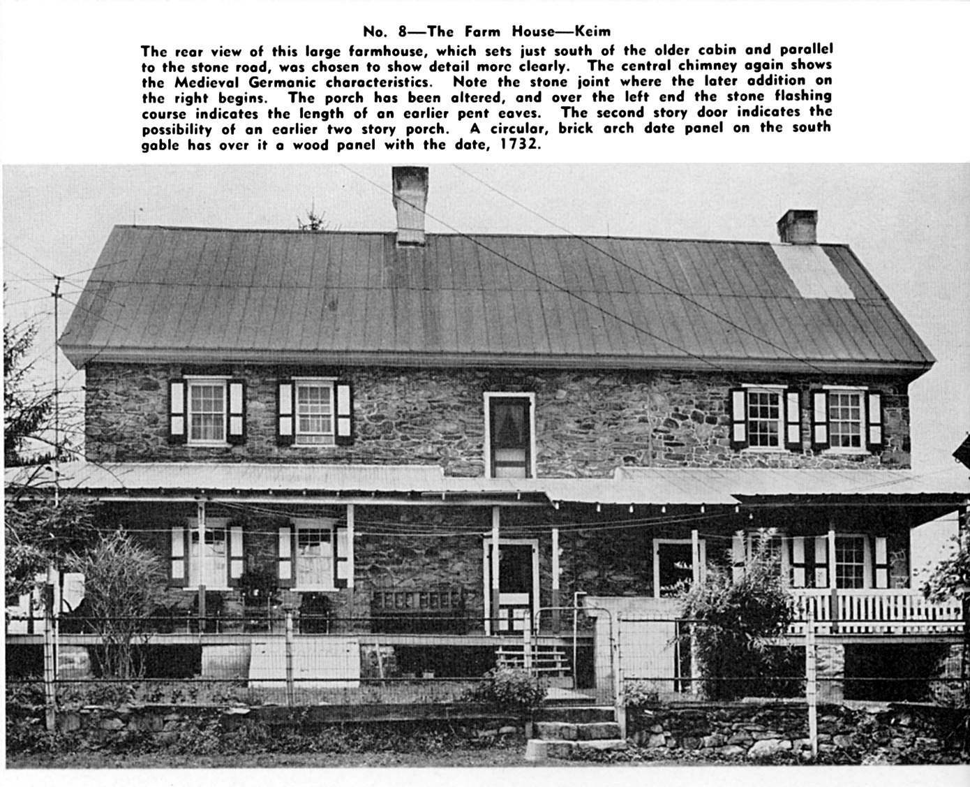
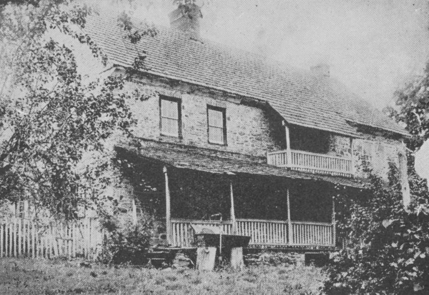
Keim House 1/2 page halftone image from photo, with paragraph of descriptive caption; published in "The Dutchman," Winter 1954, page 22.
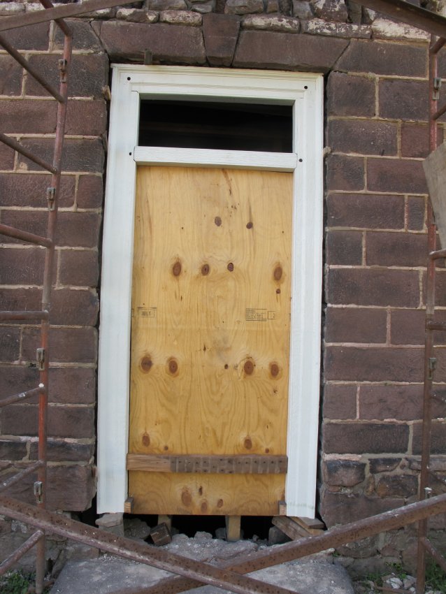
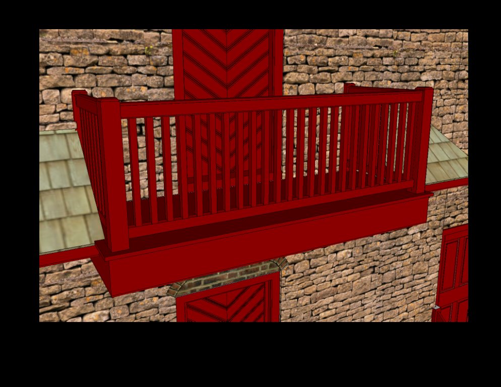
The 2d story doorway did not open to a 2d story porch, as suggested in the photo caption, but led to a balcony or “gallery”, which was reproduced in the 2012-2013 restoration campaign.
Issue also contains similar entry for Keim Cabin {n}. See KCTX3--1002.01.054.
{n} now considered a farmstead "ancillary" structure built contemporaneous with the 1753 farmhouse, not an earlier "settler's cabin" (Pendleton, Philip, "Oley Valley Heritage, The Colonial Years: 1700-1775," p. 91, caption and pages 90-92, text).
Laurence Ward, Updated 2021
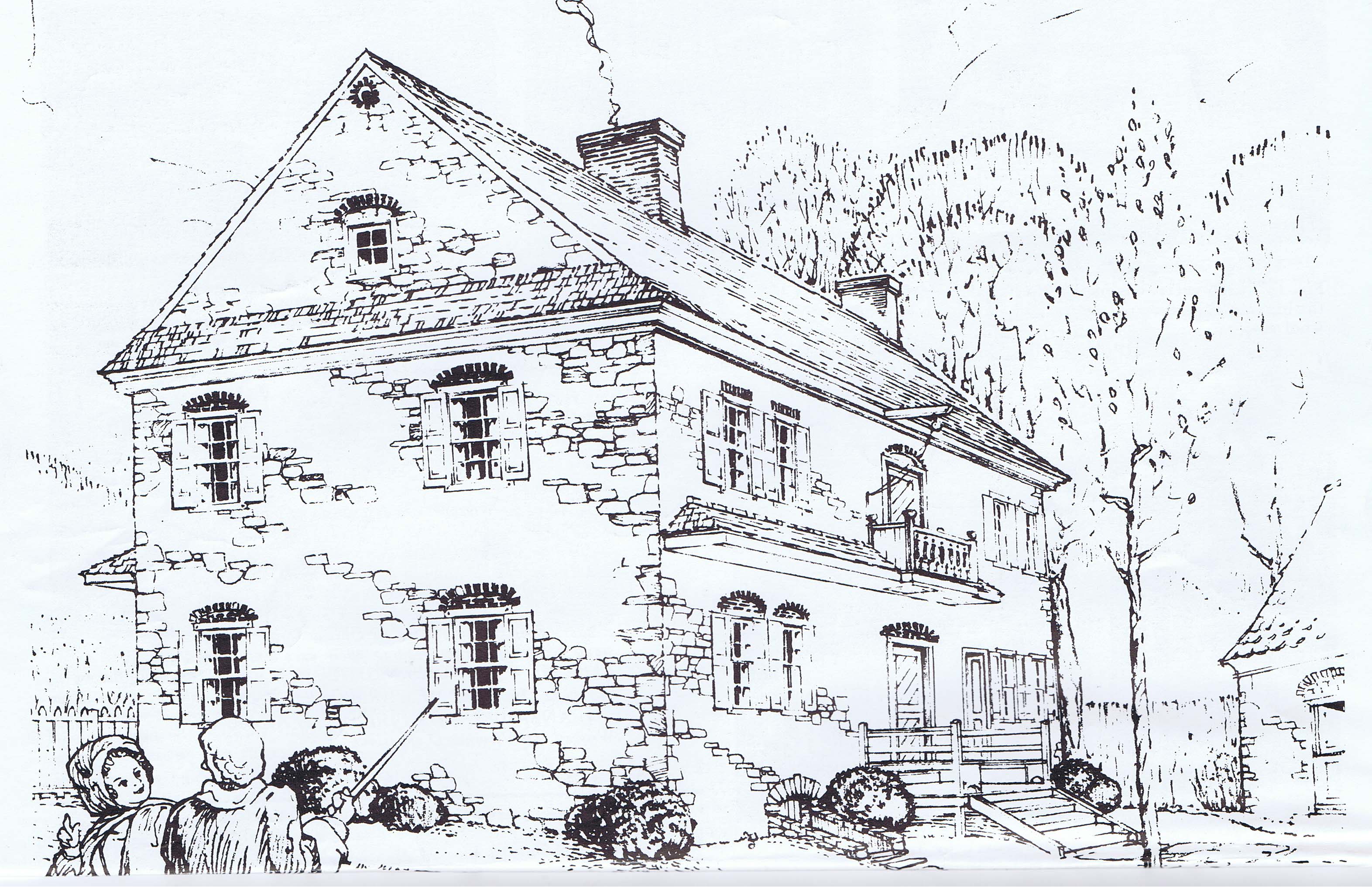
Perspective drawing of the Jacob Keim “Manor House” from the southwest, published in the copyrighted April, 1975 issue of “American Folklife, A Monthly Newspaper Devoted to the American Culture”. This image and the text excerpts are published here with the generous permission of Richard Shaner, Publisher, Managing Editor, and principal contributor to the essays and captions of "American Folklife."
In the text accompanying this rendering, Mr. Shaner observed that “A colonial balcony on the south side of the Keim Manor was altered when the home was given a huge porch which currently covers two sides of the manor. Upon investigation the staff discovered that the old porch ceiling still contained the original out riders to the colonial balcony…. Also incorporated in the porch roof line on the south side was an original out rider for the colonial pent which joined the balcony. This out rider gave…the exact measurement for the depth of the original colonial pents and an idea of their pitch.”
The perspective of this rendering suggests a symmetry in the façade that did not exist in the main elevation of the original 1753 house. The added bays to the east [right] of the door and balcony date to about 1800. The originally asymmetrical placement of the door in the east end-bay resulted in a “side-passage” alignment of the kitchen entry and second story balcony. Most of the antecedent and contemporary houses with a balcony were central-passage “Pennsylvania-Georgian” types such as “Grumblethorpe” in Germantown [Lithographic perspective view in "Quaint Old Germantown," Plate VIII], the Peter Wentz house in Worcester Township and Muhlenberg Houses in Trappe (both in Montgomery County), and “Bellaire” in Philadelphia [see "Worldly Goods," p. 84, and Kornwolf, Vol. two, p. 1223]. All houses cited except Wentz currently display a balcony surround of neo-classical turned balusters and molded handrail; Wentz’ rendering is scroll-sawn “splat” form, apparently based on the choir-railing at Trappe Lutheran Church.
The Keims were wood turners by trade, producing lathe-turned spindles and possibly balusters in the nearby and contemporaneous workshop structure southeeast of the house. Nonetheless, the vernacular Georgian houses cited above, with centrally-aligned balconies with turned balusters, would not seem to provide compelling templates for re-producing a balcony for the decidedly Germanic, asymmetric, and uncoursed masonry façade of the Keim house. Currently under consideration is a plain or edge-beaded board form, as suggested by a board railing on the second floor of the house.
The porch on the west gable wall and south eaves wall mentioned in this article was almost certainly added in the 1930s, based on photographs and analysis in record KR11PH3 [see photos and accompanying text in archive records KHPH8--1002.01.027, KHPH9--1002.01.044 & KHPH13--1002.01.057], and is without historical precedent as to form or appropriate scale with respect to the earliest bays of the house. The intermediate porch [see KHPH9--1002.01.044]--probably constructed circa mid-nineteenth century after disintegration or removal of the original pent roof--did not wrap around the corner or extend across the gable wall. Neither porch roof tucks closely under the projecting stone flashing course, which therefore does not effectively protect the joint between the porch roof and the masonry wall from moisture infiltration, as it did for the original pent roof [see pent on road-front (north) eaves wall, which provides a virtual template for the proposed pent roof on the south eaves wall].
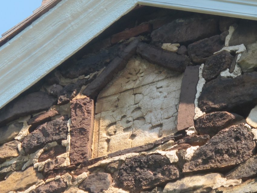
Other period or recreated early details rendered in this drawing include: central chimney on original bays; gable-end chimney on early addition [right bays]; pent eaves on west gable; pent roof on south eaves wall; second storey “colonial balcony”; brick oculus vent in west gable apex; brick relieving arches; western corner of original pent roof on north eaves wall; stone-arched cellar entry; northwest corner of 18th-century ancillary building [right edge of drawing].
See KHTX2--1002.01.021 for the full text printed below this drawing reproduced on page 12 of the issue cited.
Archive record KHTX8--1002.01.048 is the text accompanying a conceptual northwest perspective drawing of the original manor house by Gerald O’Brian, rendered without the early eastern addition, and published on page 12 of the April, 1974 issue of Richard Shaner’s “American Folklife.”
Laurence Ward, Updated 2020
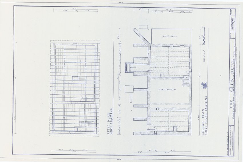
These drawings from the 1980s show the Keim House prior to its restoration, which included removal of the 1930s porch [see record KR11PH3], reconstruction of stone stairwell to cellar [KR11PH1], reconstruction of the original 1753 pent roof [KHPH19 and KHPH13], and restoration of the first-period 2d floor exterior balcony and plastered cove cornice applied to original coved brackets radially cut into attic joist-ends.
Larry Ward
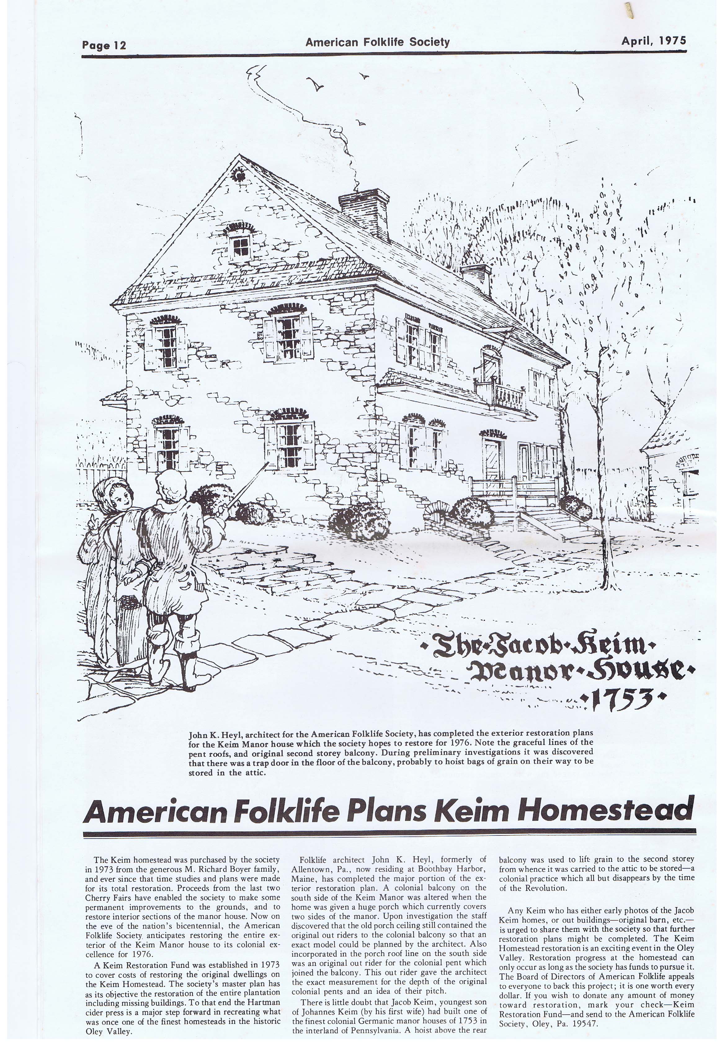
Full-page article with illustration from page 12 the April 1975 issue of "American Folklife," newsletter of the American Folklife Society.
Article briefly outlines restoration plans for the Jacob Keim Farmstead, focusing on balcony, porch, and Hartman cider press. Also requests Keim descendants to share property photos as well as an appeal for funding.
At the time this article was written Keim Farmstead was owned by American Folklife Society.
Also see record KHDWG1--1002.01.070 for further information regarding the drawing that appears as part of this article.
November 2017 Sites & Structures Newsletter Update:
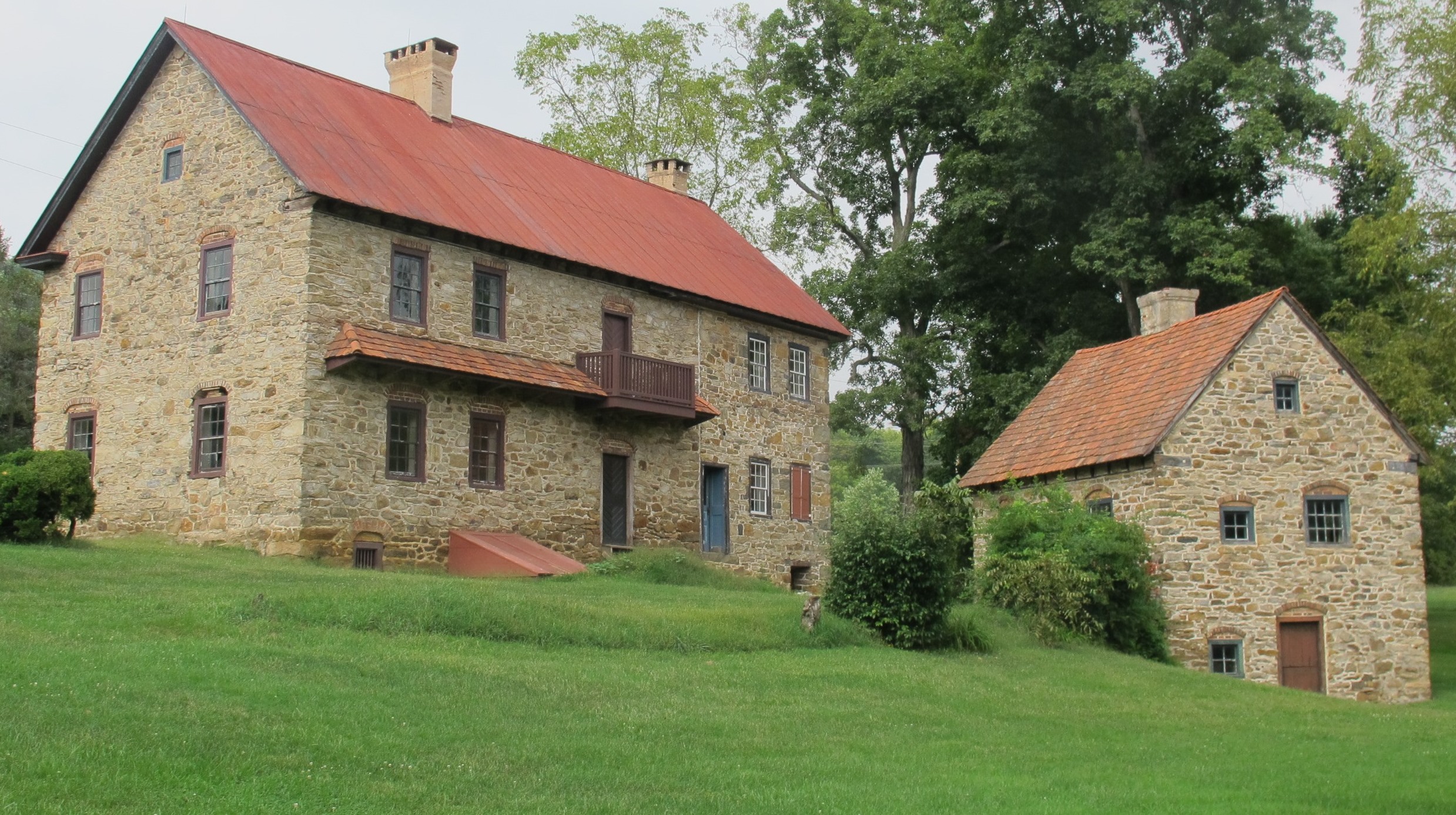
Keim House: The Trust’s five-year campaign to restore the Keim House to its 1753 architectural composition and appearance was completed in November, 2016. Within a month, National Historic Landmark status [see plaque photo] was awarded to the house and wood turner’s shop, a rare recognition celebrated at the Trust’s November 4 th, 2017 Gala Dinner. A month earlier, Preservation Pennsylvania had conferred its statewide Preservation Stewardship award on the Keim project, which re-created the pent roof, balcony, and plastered cove cornice, and restored the stone steps and stone-arched entryway to the half-cellar under the first-floor Stube and Kammer.
Mouns Jones House: Photographs taken a few years after the roof had collapsed in the late 1950s indicate that the ten exposed joists supporting the 2d floor were "edge-beaded", a refinement which will be recreated in detailing this important architectural element. "Edge-beads" had been specifically noted on a 1957 drawing by the Historic American Building Survey, now lodged in the Library of Congress. None of the early joists survive, thus the photographic evidence and HABS note, entirely consistent with one another, are crucial in determining the authentic treatment to be applied to the replacement "floor-beams". X-ray analysis of the primary elements of the early mortar used in the foundation and walls of Mouns Jones’s house has determined the precise chemical composition of the early lime binder. This "dolomitic" limestone type is nearly identical to geologic formations close to the northern range of the Mouns Jones tract nearly four miles north of his surviving stone house. An American source has been located for chemically and functionally equivalent lime-mortar that will be used in the masonry re-building campaign in 2018.
George Douglass House: With the generous aid of a Pennsylvania Keystone Grant, matched by funds from the Donald & Esther Shelley Foundation, the Trust will undertake a major restoration program in 2018. The primary objectives will be completion and stabilization of all flooring in the building, interior plasterwork, and re-plastering of the exterior "encircling" [yes, we know it’s rectangular!] coved cornice, and complete restoration of the "best parlor" and its elegant and surprisingly colorful paneled and moulded woodwork. The completed project will accommodate the re-dedication of the structure as the "Shelley-Pendleton Education and Exhibit Center" as resolved by the Trust’s Board earlier this year.
Morlatton Village Pathways: In 2018, stone-bordered and stabilized-soil paths will be installed to provide access to all building in the Village and to the Thun Trail. The pathways plan has been approved by the Trust’s Board and has been submitted to Amity Township for its review. The pathway surface material, suitable for pedestrians, cyclists, and wheelchair-borne visitors, will be acquired from the same local quarry that supplied the durable top-dressing on the Village parking areas. The border-stones leading to Trust buiildings, which will provide containment and weed-buffering for the pathways, have been gathered from the Village grounds.
See record HPTSSR46 for additional discussion of the above issues.
Larry Ward, July, 2022
Series of 19 images showing perspective views of the Keim House and other dwellings, detail views depicting evidence of an early plastered cove cornice on the Keim house, and other related photos, including images of houses built during the same quarter-century period as the Keim house and earlier English antecedents displaying plastered cove cornices.
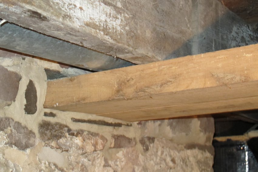
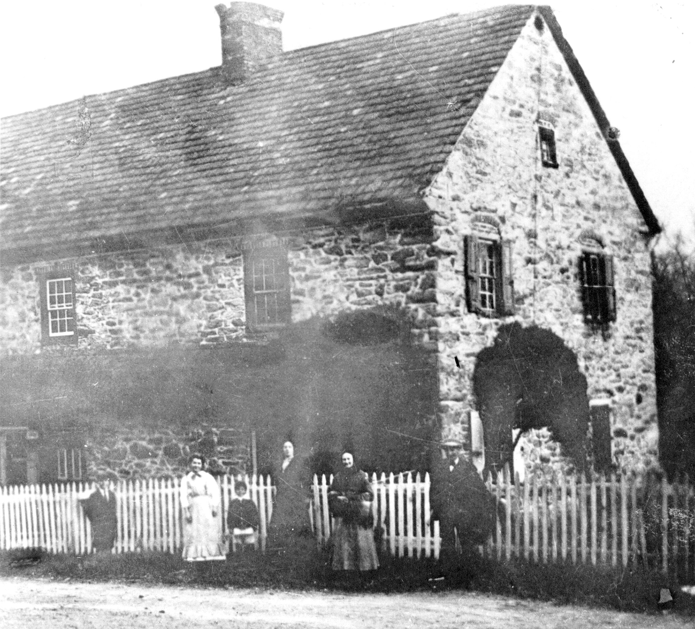
Image #1, an early 20th century view, appears to show deteriorated remnants of a coved plaster{a} cornice under the second story eaves of the 1753 house [left of roof extension above the second story balcony], and on the c. 1805 addition [right of roof extension]. Images #2, 3, and 4 are colored digital images provided by restoration craftsmen and consultants Tom and Chris Lainhoff, showing coved oak joist-ends{b} with nail holes for lath, confirming that an early plastered cove cornice existed, most probably from the first period of the 1753 house. This conclusion is reinforced by the un-coursed "rubble" masonry walling behind the cornice [Images #3, #4, & #5]. Such coarse stonework would not be seen behind the plaster and lath of the cornice and is therefore not masoned as methodically as the visible wall ranges of the house. As a comparison and contrast of masonry methods on the same building, the wall ranges behind each Keim house "pent" were as carefully laid-up as all other exposed ranges of the structure because the pent roofs were not ceiled {c}.
{a} In modern usage, "plaster" ("plaister" in early British terminology), is sometimes confined to interior finishes, and "stucco" is limited to lime-based rendering applied directly to exterior wall surfaces. Early plaster was extruded ["keyed"] between wooden lath, originally riven [sometimes "hewn"], and later sawn, for anchorage.
Some scholars consider the interior-"plaster"/exterior-"stucco" distinction to be arbitrary and historically unwarranted [see Curl, A Dictionary of Architecture, Oxford U. Press (1999), page 645]. Other respected authorities seem to prefer "plaster" in describing interior renderings, invoking the earlier term "roughcast" for coarsely aggregated exterior coatings [e.g., Lounsbury, Carl, Editor, An Illustrated Glossary of Early Southern Architecture and Landscape, page 279]. In the context of Mid-Atlantic vernacular building forms and practices, the highly regarded authors noted that "Stucco…[was] sometimes applied to interior walls…(though more commonly to describe an exterior finish)" [Lanier & Herman, Everyday Architecture of the Mid-Atlantic…Buildings and Landscapes, Johns Hopkins University Press (1997), p. 113]. The legendary Renaissance stone mason and architect Andrea Palladio invoked the term "stucco" to describe the decorative plaster coating applied to interior niches in his villas.
Other scholarly textual sources uniformly describe cornices as "plastered" when specifying the material applied to exterior coved eaves transitions (e.g., Richie, Kornwolf, Murtagh, Schiffer, Tinkcom & Simon). It is clear that there is no consensus among the academic community endorsing the use of the terms "plaster" and "stucco" based merely on interior or exterior applications.
{b} Compare the lath-nailing system of the George Douglass house, where concave brackets are suspended from the sides of the cantilevered attic-floor joists [see Image #6] projecting beyond the top of the rubble segment of the wall, and are footed on the projecting upper surface of the squared and dressed sandstone blocks forming the top course of the "ashlar" façade. [Image #6, photo "GD cove brackets 2", 8/23/13]. Images #7 & #8, Photos 2950 and 2951, 7/12/13 show surviving plaster fragments of the early cove cornice on the Douglass house [Images #9 & #17]. The convex view in Image #7 clearly shows the thin plaster "keys" which extruded through the narrow gaps between lath, securing the finished cornice in the coved profile established by the brackets.
{c} earlier: "sealed", typically with board sheathing.
The nail holes in the coved joist-ends of the c. 1805 addition to the 1753 Keim house are spaced differently from those on the early house, indicating that the two cornices, though approximately conformed in dimension and cove radius, were applied in different periods, probably separated chronologically by the approximately half century between the 1753 house and the Federal-era addition project. Therefore, the two cornice segments, though jointed in some manner when the addition's cornice was plastered, never formed a monolithic concave band across the contiguous eaves of the two house-blocks. Unless the cornices were re-plastered contemporaneously in a later period [of which there is no evidence], they were never unified in a single plastering campaign. The current [2013] restoration program relates only to the 1753 house, including its cornice. The coved plaster cornice on the c. 1805-10 addition will be considered for a future restoration campaign.
One of the earliest cove cornices in the Philadelphia region appeared on the three bay pre-Georgian Anglo-Pennsylvania Chalkley [Letitia Street] house (c. 1703-1715; see Tatum, Penn's Great Town, plate 6, and Fig. 2 in Smith, Two centuries of Philadelphia Architecture, 1700-1900, offprint, pp. 291-303, from Transactions of the American Philosophical Society, New Series, vol. 43, Part 1, March, 1953, which describes the cornice as constructed of wood), built in central Philadelphia and since 1883 situated on its re-located site in Fairmount Park. Smith's "Two Centuries" paper notes in footnote 6, p. 290, "three houses with pent roof and cove cornice"…[on] Cuthbert Street in Philadelphia.
Another early Philadelphia house with a cove cornice, "that would become so typical of the Delaware Valley" [Kornwolf, Architecture and Town Planning in Colonial North America, Vol. Two, p. 1223], is the surviving two story, five-bay "Bellaire", c. 1714-1729, an early Georgian plan-form with English Baroque decorative elements, and built for the prominent Quaker Mayor of Philadelphia and Provincial Treasurer, Samuel Preston [see Worldly Goods, p. 84, Phila. Museum of Art, 1999].
The "High Street" [2d and Market] "Greater" Meeting House, built c. 1695 and re-built in 1755, and the old Court House/Town Hall across the street from it, also featured full-perimeter ["encircling"] coved and plastered eaves cornices in their early periods [see Tatum, op cit., plate 8].
A five-bay brick house, the 1730 William Miller house in Avondale, Chester County, PA, prominently boasts another "encircling" plastered cove cornice, added at the attic floor level when the third story was erected in 1771 [Schiffer, Survey of Chester County, Pennsylvania, Architecture, 17th, 18th and 19th Centuries, page 61, Image # 19, photo miller cove cornice]. It is not clear whether a cove cornice appeared on the first-period house at the original 2d story eaves level.
Another four-range cove cornice, restored in 1950, appears on Wright's Ferry Mansion, Columbia, Lancaster County, PA, built in 1738 with roughly coursed limestone "rubble" and hybridized by some Germanic details for the Quaker "Renaissance woman" Susannah Wright.
Yet another Quaker structure with a most imposing surrounding cornice, described as a "concave, plastered support," above roughly coursed rubble walls and segmental brick "relieving" arches, is the 1768-1769 Buckingham Friends Meeting House in Bucks County, PA [see photo and caption at pp. 64-65 of Stone Houses… Bucks County and Brandywine Valley by Richie, Milner, and Huber (2005)].
It seems reasonable to infer from the early Philadelphia-area examples cited, (and some in West Jersey) that immigrant plasterers from England, who probably received training and experience in the post-fire English Baroque tradition{d}, would have been familiar with and probably influenced by 16th and 17th century specimens of prominent plastered coved cornices in their homeland. Such traditions would have been preserved and transmitted within the British building trades within the prevailing and ancient master-journeyman-apprentice system under the auspices of craft Guilds devoted to the "art and mystery" [craft methods and trade secrets] of each artisan group. Plastered cove cornices, some on half-timbered town-houses with curvilinear plastered eaves-panels, appear on substantial houses in 16th and 17th century England. Examples would include half-timbered 16th century structures Congleton, and Moreton Old Hall, both in Chesire, and a dormered three and a half story Town House in Bisley Street, Painswick, and the symmetrical three-bay pre-Georgian house in Lechlade, also in Gloucestershire. These antecedents, graciously brought to the Trust's attention through the scholarship of Joe Kindig III of York County, would have provided an abundance of prototypes for emigrant plasterers re-settling in Penn's distant colony, and their protégés. Examples from the late half-timber period appear in photographs published in British Bouquet, An Epicurean Tour of Britain (1963) by noted architectural photographer and etcher Samuel Chamberlain [images #10, 11, and 12].
{d} This tradition included numerous variants and applications, in architecture and decorative arts, of the "C-scroll" motif and the Renaissance (originally Roman) versions of the "cavetto" moulding profile.
The National Register application on behalf of the c. 1698-1700 Reynolds house in Bristol, RI describes "an original plaster cove cornice" as "a rare survivor following late seventeenth century English precedents". Several plastered cove cornices in New England and the southern tier of the mid-Atlantic states are recorded in HABS and National Register records.
An impressive concentration of houses with coved lath-and-plaster cornices, some with shed-form roofs ["pent eaves"] across the gable walls and most constructed in the 1740s, appeared in German Township, later the Germantown wards of northern Philadelphia but then an independent community established by a Penn grant 10 miles north of Philadelphia in the late 17th century. Notable among these are the earlier (of two) Gorgas ("Monastery") house, 1746-47 [see image #13, photo #gorgas], and the earlier (of two) Daniel Pastorius house [1748, image #14, photo #3402], later known as the Green Tree Inn. Other mid-18th-century stone houses in Germantown with plastered cove cornices include the early 18th-century De La Plaine house [demolished 1885], which was gambrel-roofed and dormered (wounded Civil War veteran John Richard's lithographic Plate X); and the (Van Lauchet) Weygandt house (Richard's Plate XXX , also gambrel-roofed, with an asymmetric street façade. Plate XLVI also suggests a coved cornice on the dormered section of the house on Thorp's Lane, near the site of Weber's and Thorp's Mill. Richard's detailed drawings were published as lithographic reproductions by the Pennsylvania German Society in Vol. XXIII of its "Proceedings", Lancaster (1915), in the essay and plate collection called "Quaint Old Germantown."
The design currents and craft proficiencies producing the coved plaster cornices in the Philadelphia region in the earliest decades of the 18th century reached Germantown by 1740, and appeared in more remote northerly settlements by the middle of the 18th century, as exemplified by the cornices at Pottsgrove [1752], Keim [1753], Eshelman [Lancaster County, 1759], Abraham Landis [Lancaster County, 1763], and George Douglass [Amity Township, Berks County, 1765].
The most prominent "backcountry" house with plastered cove-profile cornices (and an English Baroque-influence re-constructed door-hood) is John Potts' "Pottsgrove" mansion [image #15, photo #265, 9/11/12], built a year or two before the Jacob Keim house, and about 12 years prior to the 1765 George Douglass house, which displays a cornice quite probably influenced by Pottsgrove, though in a more attenuated and vernacular interpretation of this and other design details. The Pottsgrove cornice is plastered on lath nailed to coved brackets scribed and "sistered" to the coved ends of the attic floor joists projected through the top courses of the walls. This system and its lath nailing pattern for the early plaster cornice, differing from the coved joists at the Keim house and the suspended brackets at the George Douglass house, can be viewed at Pottsgrove via a strategically placed mirror through a window in a second floor chamber, as the brackets and a coved plaster segment are now sheltered by the "ell" addition constructed c. 1820 and butted against the original 1752 house.
This group of houses--Pottsgrove, Douglass, and the earlier Germantown structures--all feature coved cornices framed by crown and bed mouldings above a coursed and dressed "Georgian" façade. The Keim house departs from this essentially Pennsylvania-Georgian design approach, lacking the evenly coursed ashlar block-work and central passage façade-symmetry of most of the other houses cited. The 1753 Keim house also apparently omitted a traditionally moulded "crown" piece forming the outer (and upper) termination of the plaster cove. The restored top trim board will be beaded and finished with a chamfered "drip-edge."
A slightly later (c.1768) pre-Revolution structure with several design details in common with the Keim house is the Bethlehem Widow's house depicted as plate 45 in Murtagh, Moravian Architecture and Town Planning, p. 87, and Brumbaugh, Colonial Architecture of the Pennsylvania Germans, plates 76 and 79 [captioned "Moravian Seminary"]. Although the Widow's House is laid-up in courses, is symmetrical on its principal elevation, and is dormered, both it and the Keim house (as well as the Buckingham Meeting House cited above) "relieve" the rectilinear geometry of their fenestration openings with segmental brick arches, and refine their eaves transitions with coved plaster cornices arcing between bed- and crown-mouldings.
The 1753 Keim house is undoubtedly one of the few random rubble structures in the region (perhaps a unique example) with a three-room Germanic floor plan, asymmetric eaves-wall fenestration, a coved plaster eaves cornice, a stone-arched cellar doorway, and a cantilevered balcony [to be reconstructed] above the end-bay ["side-passage"] doorway.
Two Lancaster County Germanic-Georgian houses with mixed characteristics and "encircling" coved plaster eaves cornices are:
A. the 1759 house in Conestoga Township, Lancaster County, PA constructed for Mennonites Benedict and Anna (Stehman) Eshelman [cfr. photo and floor plan in Falk, Architecture and Artifacts of the Pennsylvania Germans (2008), pp. 144-145]. Unlike the Keim House's emblematic three-chamber stove room ["stube"] plan, the Eshelman house includes a slightly off-center walled passage and rear stair-hall, and four rooms on the first floor, the larger pair (kitchen and stove-room) to the left of the hallway. The Eshelman façade is laid up in coursed and roughly dressed block-work and a full perimeter rubble course between first and second story windows, indicating that an early ceiled pent roof had been removed, an inference further affirmed by a projecting flashing course and outlooker remnants, apparently truncated when the pent was removed; and
B. The Abraham Landis house in East Lampeter Township, c. 1763 [Lestz, Lancaster County Architecture, 1700-1850, p. 54, photo].
Other Keim House Details include: 19th-century roofed porch [Image #1], replaced by the "L" form two range porch in the 1930s; second floor balcony [to be re-constructed in 2013-14], framed onto cantilevered "outlookers"; flashing ("drip") course for earlier pent roof (removed, presumably to make way for the porch roof shown in this record).
Note the absence of porch or evidence for porch on west gable wall; the L-form 20th-century porch succeeding this one is depicted in record KPH4--1002.01.009. A history of this 19th century porch and its 1930s successor, removed in 2011, and related photographs and other images appears in archive record KR11PH3--1002.01.092.
The vertical separation between the "flashing" course (which sheltered the joint between the original pent roof and the eaves wall) and the top of the porch roof shingles in these "vintage" photos appears to have been approximately 12-14 inches. With this separation, the flashing course did little to prevent precipitation from penetrating the joint between the pent roof and eaves wall, gradually and inevitably eroding or rotting the rafters and lathing of the porch roof. Signs of such decay were evident on removal of the early 20th century porch rafters and other framing members.
Laurence Ward, 2011; updated February, 2021
Series of 50 digital photographs depicting the removal of the c. 1930s porch from the Keim House {q}.
1. {q} Image #47 is a panoramic view of the Keim farmstead, a c. 1930, photo taken by Amandus D. Moyer, and is used with the generous permission of the photographer's granddaughter Susan Harvin. Note the absence of a porch on the west gable wall.
The two earliest Keim buildings, the 1753 farmhouse and its "ancillary" structure, and the Federal-era addition to the 1753 house formed an organic and architecturally distinguished farmstead which prospered during Keim family occupancy and administration for nearly sixteen decades. The surviving structures remain in remarkably well-preserved and substantially undisturbed condition, never having been substantially "improved" with interior plumbing, electrification, or other modern utilities, or structural or cosmetic "remodeling". The only significant exceptions include modification of the roof system and materials on the 1753 house and the early addition, and the construction and recent removal of the disintegrating 20th century porches on the south and west walls.
2. Fortunately, this unmolested status continued through the 65 years of Boyer family ownership which commenced c.1913 and ended with the Boyers' conveyance of the site and its structures to the Historic Preservation Trust of Berks County. The undisturbed condition continues under the stewardship of the Trust. Despite the passive preservation of the period buildings in their early condition throughout two and a half centuries, much of their distinctive architectural form, character, scale, and defining details were concealed and distorted for more than a century and a half by two successive porches joined to the south eaves walls. The 1930s porch extended the porch northward, appended to the west gable wall.
During the first 258 years of its existence, the 1753 house displayed three projecting roofed structures, a pent roof and 2 floored porches, appended in the following sequence to the south eaves wall. The porches described in "B" and "C" also extended across most of the contiguous eaves wall of the Federal-era addition; "C" also abutted the west gable wall, forming a prodigious L-shaped "piazza, in modern terms."
A.The first of these structures was a "pent"{a} roof, without above-grade flooring, probably un-ceiled{b}, integral with the original 1753 masonry wall construction, and carried on cantilevered "outlookers" which were cut off when the 19th-century floored porch described in "B" below was constructed. This early pent was structurally, dimensionally, and functionally equivalent to its counterpart, now reconstructed on its original outlookers on the north eaves wall of the 1753 house [Image #1, photo from record KHPH2--1002.01.009 and Image #11, photo 4300, 7/1/11].
{a} a contraction of "appentice," meaning an attached ["appended"] sheltering structure joined to a principal building [Lounsbury, Carl, An Illustrated Glosssary of Early Southern Architecture and Landscape, Univ. Press of VA, (1999), p. 267].
{b} This inference is based on the following considerations:
1) There is no framing evidence for a ceiling ["soffit"];
2) There is no soffit sealing the underside of the northern pent roof; and no evidence of nailing to the bottom surface of the outlookers carrying it.
3) The walling between the outlookers and the rafter tops is laid flush with the plumb-lines of the exposed masonry and pointed identically to the wall ranges of all exposed elevations of the 1753 house. When an 18th-century pent roof was ceiled [earlier, "sealed"], such as at the George Douglass House, the wall segment concealed by the pent roof and its ceiling is typically laid in the "random rubble" method without regard for uniform coursing or wall-plane consistency [Image #2, photo #3842, 6/5/11].
Pent roofs and hoods [usually referring to a projecting structure, pedimented or in shed-form, above a single door or window] were distinguishing elements of 18th-century vernacular architecture in the region. They served the same function in Anglo-Pennsylvania and Pennsylvania Germanic structures: protecting the woodwork and joints forming, framing, and securing wall openings, thereby reducing deterioration from saturation of mortar joints and foundation masonry .
The original pent roof framing on the north [road-side] eaves wall furnishes an ideal template and dimensional basis for framing and detailing a restored pent structure on the south elevation. Accordingly, the authentic reconstruction of the southern Keim pent roof will create a structure which is not cieled or sided, but returns to the masonry wall with a half-hip based on the existing pent on the north eaves wall. This framing system will consist essentially of a series of half-trusses composed of rafters footed on a front plate, and joists mechanically fastened to the original outlookers, which had been cut-off at the wall plane to accommodate the 19th century porch. Lath strips will support the authentic roofing material, clay tiles, the same material used on the original roof of the house, based on photographic evidence [see Image #11].
The original pent roof was joined with the eaves wall tightly under the flashing course, which consisted of horizontally aligned stones ["flags"], which are flatter than those in the ambient un-coursed wall ranges of the early house block. This projecting band of stonework [Image #3, photo 5522, 8/20/11] was designed to shelter the joint between the pent roof and the wall masonry from moisture infiltration. The thin stones forming this flashing ["drip course"] had been masoned into the original structure by embedding them as cantilevers with fulcrums at the wall plane. This structural integration demonstrates unambiguously that the pent roof and flashing course were part of the original 1753 construction campaign and survived as a sheltering "overhang" for a more than a century.
3.
Demolition of the pent roof in the 19th century, removing its cantilevered outlookers, and construction of a porch roof meeting the wall a foot below the projecting stonework rendered the flashing course conspicuously redundant. This anomaly was the least intrusive effect of the porches, as discussed below.
B. The first floored porch, with its roof carried on turned support posts, was erected during the second half of the 19th century in replacement of the original pent roof. [Image #4, Photo 2 from KHPH9--1002.01.044]. This 19th-century porch{c}, a structural and functional expansion of the first-period pent roof, survived all Keim family members who had occupied the farmstead through 1913.
{c} This date attribution is based on the scale and profiles of the turned support posts (see photographic images in Archive record KHPH9--1002.01.044). This structure is probably the "back porch" which Betsy Keim, the last surviving Keim to reside at her ancestral farmstead, was sitting on when her photo [Image #5] was taken "in the "early 1900's" for the Reading Eagle newspaper [see the halftone reproduction of this photo on page 27 of "American Folklife," in the issue entitled "Oley Valley, American Cultural Island," Vol. 1, No. 7, published by the American Folklife Society in 1973, and the essay "The Keim Family of Lobachsville" by John E. Eshelman, published in The Historical Review of Berks County, October, 1955]. The photo was also published in the Reading Eagle on Sunday, November 5, 1911, within a few weeks after Betsy's death. An uncropped print of this photograph (showing Betsy bare-footed) was reproduced on page 15 of "The Oley Valley, A Photographic Journey," published in 2010 by The Oley Valley Heritage Association. The caption cites a probable date of "c.1910."
The pent roof and its "outlooker" supports were removed and replaced by the 19th century porch roof which was set at a lower level than the sloped plane of the early pent, and displayed the first floor deck raised above the exterior grade on stone piers, creating a sheltered outdoor extension of the interior living space. This was the first significant exterior modification of the original house after the Federal extension of the dwelling space more than a half-century earlier.
This 19th-century porch was laid out along the south eaves wall of the 1753 masonry block and a portion of the Federal-era addition, terminating at both ends and appended solely to the southern eaves wall. It sheltered wall openings and their woodwork, as had the early pent on the 1753 house block. It also provided cover for the exterior doorways into the kitchen of the original house and the Federal addition, and formed a canopy for outdoor communication between them.
As shown in Image #4, a J. Winslow Fegley photo taken c.1915-1925; see Farming Always Farming, p. 85], the first porch roof joined the masonry wall approximately one foot below the flashing course delineating the meeting of the original pent roof tiles and the eaves wall masonry. This vertical separation between the top of the 19th century porch and the flashing course confirms that the replacement structure was not the original roofed projection on the south eaves wall. The original "pent" structure would have fit snugly under the projecting "flag-stones" forming the sheltering "flashing" course, which would have provided negligible precipitation-shelter to a roof/wall joint a foot below it.
The 19th-century porch structure was undoubtedly removed preparatory to construction of the 1930s L-form porch discussed in "C" below.
C. The c.1930-1940 porch extended along the full extent on the south eaves wall of the 1753 house and the Federal addition, turning 90 degrees northward at the southwest corner of the early house and extending along the west gable wall [see Images ##6, 12, 13, and 31]. Its roof was of a different pitch and less vertical separation from the flashing course than the 19th-century porch roof [Image #4].
This later and dramatically larger porch roof was supported on posts of a bolder profile than the earlier porch [see "B" above]. The floor on the south eaves wall consisted of joisted tongued-and-grooved boards carried on massive stone piers butted against the foundation wall and "flashed" with a crude band of concrete at porch-deck level [Image #6, photo 3680, 5/23/11 and #7, 4284, 7/1/11 ].
The floor on the western gable-end wall was a thick poured concrete "slab," mixed, typically for the period between the two 20th-century world wars, with a dense "aggregate" [Image #22, photo 4394]. It buried and concealed two cellar openings in the west gable-end foundation, a ducted and grilled vent and a partially closed-up window [Image #8, photo 4266 and Image #9 photo 5854], both of which have now been partially unearthed and shielded from ground runoff by dry-laid stone "wells" seen in the photos cited.
In Image #10, photo #4339, 7/5/11, the broken red horizontal streaks on the wall [paint from the 20th-century metal porch roof] about 4-6 inches below the flashing course delineate the top of the porch removed in the 2011 project.
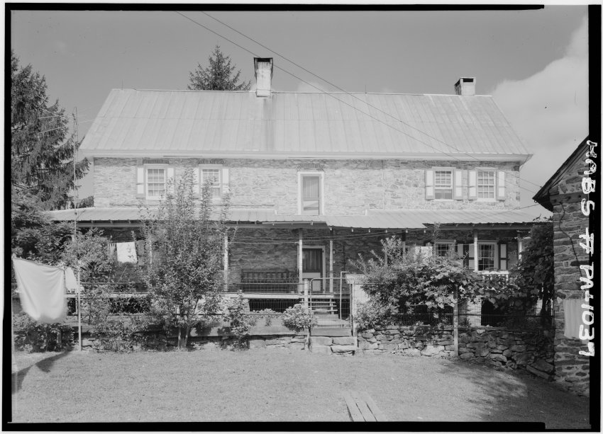
The 20th-century porch had not been built before 1912 [Image #11, the 1912 photo published in archive record KHPH13--1002.01.057. Also absent from the c. 1930 Amandus Moyer photo (Image #47), the removed porch was quite obviously constructed after 1929 and prior to 1941, when a HABS photo (Image #12, also in archive record KHPH8--1002.01.027) was taken, showing the L-form range porch surviving until its removal in 2011. Thus the 20th century porch was never a "Keim Family" addition to the living space, and there could not have been any association between the Boyer-era porch removed in 2011 and any Keim family member residing on the farm during the porch's life-span. The last Keim to reside on the farmstead was Elizabeth ("Betsy") Keim [Image #5], who died in 1911.
Since the latest porch does not appear in its two-wall configuration in the Moyer photo, (no porch appears on the west gable end of the 1753 house), it clearly was built after c. 1929 [and prior to 1941, when a HABS photo, Image #12, also in record KHPH8--1002.01.027], was taken, showing the two-range porch removed in 2011. Thus the 1930s-era porch was never a "Keim Family" extension of the living space and there could not have been any association between the Boyer-era porch removed in 2011 and any Keim family member living while the porch was appended to the house.
The construction date-range [c.1930-1940] for the modern porch falls a century or more after the conclusion of the "Period of Significance" for the Jacob Keim Farmstead. A structure as late and architecturally intrusive as the massive 20th-century Boyer "piazza" warrants removal from such an important vernacular architectural landmark, regardless of how pleasant an ambience it might have manifested during the interval of private ownership between the Keim family's tenure and the present and ongoing stewardship undertaken by the Historic Preservation Trust of Berks County.
PRESERVATION GUIDELINES
Transfer of the site and its surviving buildings to the Historic Preservation Trust of Berks County, Pennsylvania by Mr. and Mrs. Richard Boyer in 1978 imposed a set of custodial responsibilities that are fundamentally different from the essential attributes and relatively unconstrained rights of private ownership.
One of the primary obligations inherent in any preservation mission is to maintain and interpret architecturally and historically significant buildings in their documented historical context (the "Period of Significance") for the benefit and education of the organization's membership, its regional constituency, and the broader historic preservation community.
Performance of this core mission is guided by a complex and evolving (and sometimes controversial) code of principles and standards correlated to the importance, condition, extent, and architectural distinction of the surviving elements of the historic structures in the organization's custody. A fundamental axiom implicit in these guidelines requires the stabilization, preservation, and interpretation of as much of the original architectural "fabric" as survives reasonably intact, particularly those characteristic elements surviving from the historically appropriate early "periods."
Conversely, though equally compelling, non-period accretions must be removed if they are not compatible with [or, as in this case, aggressively interfere with] the essential attributes and architectonic composition and interpretation of the important early structures. A further corollary of this preservation mandate provides that intrusive or obstructive alterations must be removed, regardless of how beneficial, attractive, or appropriate they might seem in a non-historic or less architecturally significant context. When such non-period appended structures are in a deteriorated, unsafe, and architecturally intrusive condition, neither restoration nor reconstruction is an authentic or acceptable preservation option.
The National Register of Historic Places specifies 1750-1799{e} as the "Period of Significance" for the Jacob Keim Farmstead. A more recent [2007-8] Pennsylvania Historic Resource Survey Form prepared by Philip Pendleton suggests a period of significance spanning the years 1753-1830, the period during which 1753 house, the contemporary wood-turner's workshop building, the c.1800 addition to the 1753 farmhouse, and the root [also "cave" or "ground"] cellar{f} had all been constructed and functioning for over three generation of Keims as a prosperous family farm and industrial craft-enterprise.
{e} more precisely, 1753-1799, since 1752 or 1753 was the year in which the land was conveyed to Jacob Keim by his father-in-law Hoch, and 1753 is the documented year of construction of the early farmhouse.
{f} the surviving root cellar was originally the cellar of the small gabled and embanked stone structure described as a "bake oven" in the essay cited in KTX10--1002.01.050 ["Keim Bakehouse Discovered" by the late (2021) Richard Shaner, who, with the Boyer family, must be credited as the good stewards of the Keim buildings in their undisturbed forms. Research has confirmed that subsidiary trades, crafts, and commerce were common in the local agrarian culture; see Pendleton, Philip E., Oley Valley Heritage-The Colonial Years…, Chapter 2, "The Economy," pp. 29 et seq. Three generations of Keims working as wood turners would exemplify this tradition.
REMOVAL OF THE 20th-CENTURY PORCH
The modern-era porch, c.1930-40, had undoubtedly provided the Boyer family [purchasers from the Keim estate], their farm hands and loggers, and numerous visitors to the site with many hours of enjoyment and relaxation in a beautiful and historic rural setting. As a social convenience the porch was a pleasant addition to the old farmhouse and a haven for the private owners and their guests. The roofed deck also served as a comfortable meeting place and sheltered social venue during the first 33 years of the tenure of the Historic Preservation Trust of Berks County.
Nevertheless, in the context of the mission of the Trust the porch was substantially detrimental to the architectural and structural integrity of the 1753 dwelling and its Federal-period addition. Its horizontal and vertical projections and descending roof plane also destroyed the original function-based spatial relationship between the extended house and the early wood-turner's workshop nearby [with porch: Image #13, photo 3661, 5/23/11; after porch removed: Image #14, photo 5678, 8/26/11 and Image #49, photo 5529, 8/20/11].
After removal of the 1930s porch [accomplished in 2011] and reconstruction of the pent roof and balcony on the south eaves wall in 2012, the Keim House and its Federal addition now present the same iconic architectural expression as they displayed in the first period of the 1753 house and the second period included in the Period of Significance for the farmstead. This historically authentic appearance has been concealed or obscured for over half of the life of the structures by the 19th- and 20th-century porches. Their removal reestablishes the original articulation of form, function, detail, and spatial relationships of and between the period structures.
Removal of the porch was also urgent as a safety measure, considering the deteriorated condition of much of its structural woodwork [see Images #15, 16, 17, & 18, photos #4174, #4175, #4178, and #4179, 6/24/11]. Dismantling the porch also became the appropriate and necessary [and only] means of rectifying the following unacceptable conditions:
1. The massive porch, its deck and structurally compromised stone piers [Images #19, 20, & 21, photos #4189, #4190, and #4192, 6/24/11], the concrete slab under the western segment along the gable-end [Image #8, photo #4266, 7/1/11 & Image #22, 4394, 7/6/11], and the applied ["rendered"] concrete band [Image #23, photo #4162, June, 2011] serving as a "baseboard" at porch-deck level were destabilizing the stone walls by trapping moisture in the masonry. This persistent upwardly migrating moisture ["rising damp"] aggressively dissolved the lime in the early mortar and caused expansion fractures and disintegration during freeze-thaw cycles, leaving substantial quantities of degraded [sometimes, in scientific and engineering usage, "incoherent" or "friable"] and minimally functioning mortar residue [see Image #23, photo #4162, Image #24, #4185, and Image #25, #4188, 6/24/11].
Once a historic structure enters the stewardship of an organization dedicated to meeting prevailing preservation standards, the introduction of such "foreign" and destabilizing materials (such as 20th-century concrete) is "verboten"{f}. A rational corollary of this principle requires that, if present at the inception of the preservation stewardship, such infringing and destabilizing materials must be removed and the structure restored to its historic period-of-significance composition.
{f} The concrete forming the deck of the porch on the west gable end, the cellar steps, approaches, and retaining walls, amounted to approximately ten tons of extremely hard and dense aggregate, all 20th-century "improvements", which were broken up, with great difficulty, and removed from the site.
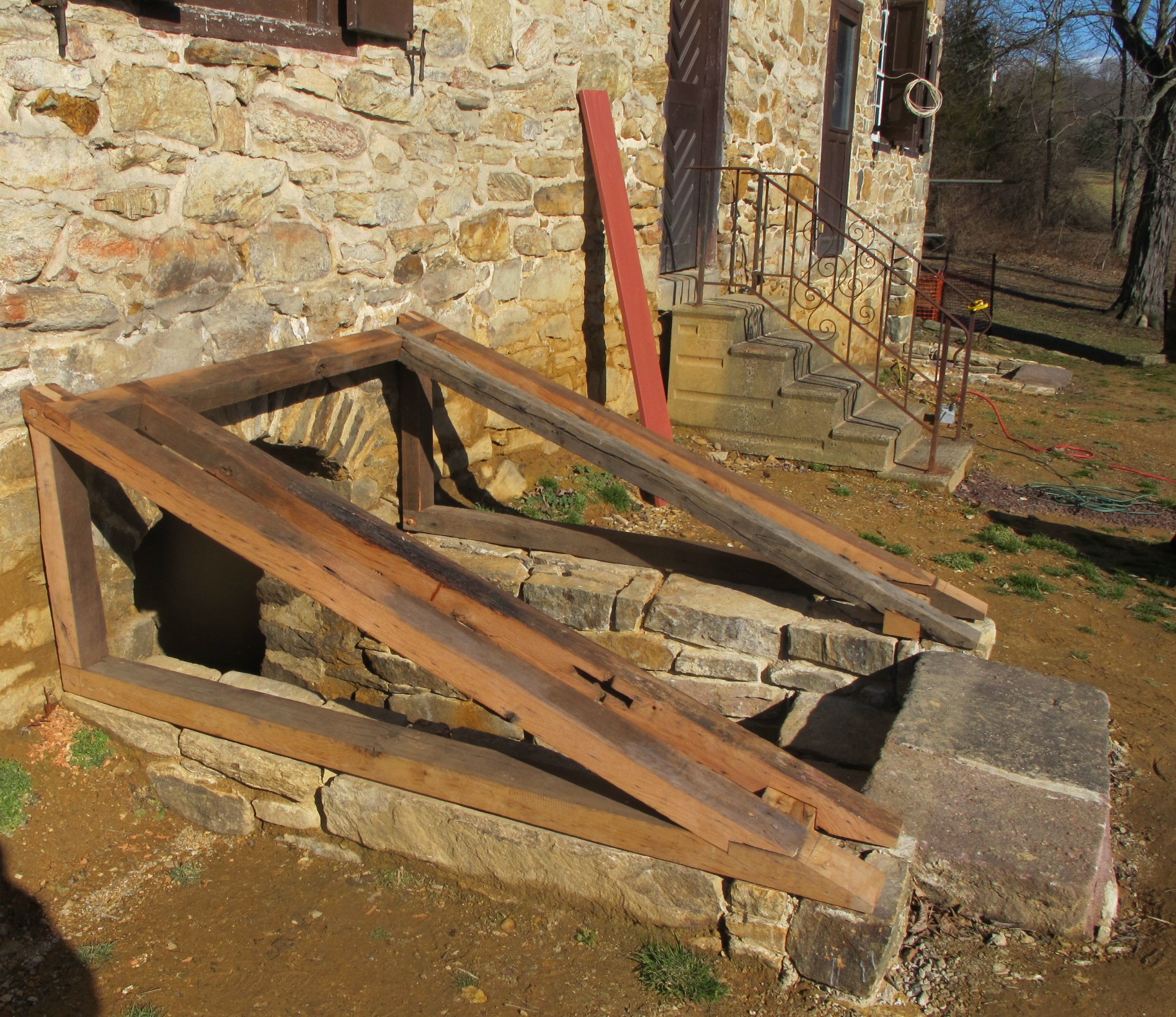
Image # 26, Photo #4180, 6/24/11 shows rotted "bulkhead" cellar doors; the cellar entry stone walls and steps have been reconstructed [see Image #27, photo # 5382, 8/19/11]. Image #28, Photos #4184, 6/24/11 and Image #29, Photo #4421, 7/9/11 show the decayed concrete retaining walls, which had replaced the original "raking" stone-masonry flank walls in the early 20th century.{n}
{n} By contrast with the massive concrete formations butted against the Keim buildings when the 1930s porch was installed, the stone "spillway" and retaining walls installed to protect and drain the west eaves wall of the DeTurk House a few miles south of the Keim site were not bonded to the early masonry, but were deliberately separated from the early walls by a pervious granular material. The stone units forming these structures function and are removable without damage or threat to the fabric of the 1767 DeTurk multi-use building.
2. The piers, roof, L-form floor deck, and superstructure of the porch, and the concrete bulkhead cellar-way concealed or visually distorted more than a dozen of the salient early elements of the 1753 house and the federal-era addition. The porch also obstructed the view of important early architectural details in the cellar foundation walls and the first floor ranges of the south elevation [Image #30, photo #3681, 5/23/11], and physically precluded reconstruction of the pent roof on the south eaves wall [Image #31, photo #3682, 5/23/11].
Any of these intrusions and obstructions warranted removal of the porch structure; all of them in combination produced an affirmative, mission-based duty to remove it.
The architectonic and spatial contrast with and without the porch is stunning: (With porch: Image #13, photo #3661, 5/23/11; after removal of porch: Image #32, photo #5867, 9/3/11).
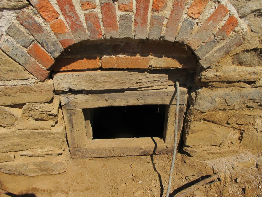
The details concealed or optically distorted by the porch elements included: window frames and sash detail; brick relieving arches spanning window and cellar-vent openings [Image #33, photo #4533, 7/13/11]; original cellar doorways [or "openways" if lacking a door through the foundation wall but protected by a "cellar cap"], including the early stone-arched opening in the 1753 foundation wall [Image #34, photo #4571, 7/15/11] and a timber-linteled doorway in the federal-period addition [Image #35, photo #4378, 7/6/11]; early wrought iron grilled vent [Image #36, photo #4629, 7/16/11]; and masonry walls with early pointing [Image #25, photo #4188, 6/24/11].
3. Removal of the out-of-period and deteriorated porch was necessary to restore the organic integrity of the original house, revealing all of its elements, its architectonic scale and detail, its expressive and rationally asymmetric{g} Germanic composition, and the function-oriented relationship between the domestic and craft-industry structures.
{g} An example of this conscious departure from exterior symmetry in the disposition of fenestration elements is the northward shift of the windows off the central vertical axis of the west gable-end wall. The geometrically normal view is curious in this respect, unless one considers that the windows are centered on the early interior walls rather than on the central vertical axis of the exterior elevation. This anomaly inferentially derives either from interior partitioning and relative dimension of the "stube" compared to the smaller "kammer" in the three-space Germanic first floor plan of the 1753 house, or from the choice of window placement to achieve optimum interior lighting for domestic activities.
4. The construction of the 19th- and 20th-century porches forced the removal of the kitchen-doorway steps from the house wall, resulting in a horizontal separation of approximately eight feet. This re-alignment and the opaque elements of the porch superstructure transformed the original adjacent relationship between entry porch and house, displacing the steps outward to the southern edge of the porch and producing radically altered perspective views of the protracted elevation and its wall-plane openings [compare Image #6, photo # 3680, 5/23/11 to Image #37, a drawing from record KHDWG1--1002.01.070, a conceptually restored view showing a possible approach to reconstructing the steps and entry landing in their original location rising from grade to the threshold at the kitchen floor level].
5. The deteriorated support piers impeded access to foundation stonework that was in urgent need of stabilization. This phase of the restoration program consisted of resetting dislodged stones in a plumb and stable alignment, replacement of degraded mortar, and repointing.
6. The porch roof made it impossible to re-create the 1753 pent roof in its original position immediately under the stone flashing course designed to protect it. As the photographs demonstrate, the upper roof-line of both the 20th-century porch and the smaller porch it replaced met the eaves wall 6 to 12 inches below the projecting flashing course, rendering the protection it was meant to provide nearly useless.
In clear and compelling contrast, the original pent roof was positioned tightly under the overhanging stone cantilevers to ensure optimum shelter for the clay tiles and wooden framing and support elements forming the pent structure.
Several original oak outlookers that supported the original pent roof survive in eroded (though structurally sound) condition on both eaves walls. Interior framing evidence confirms that they were anchored through the wall as part of the original 1753 construction. They will be preserved and re-used in their original bearing functions for the "pent."
7. The porch roof and rafters interfered with preservation and reconstruction of the balcony that was carried on outlookers projecting at second floor joist level [Images #38 & 50, photos #3679, 5/23/11 and #4845, 7/26/11] outside the second story "chevron" door. The surviving elements will be carefully inspected, documented, and engineered to provide a mechanically sound and reasonably authentic basis for reconstruction. Image #37, a drawing from record KDWG1--1002.01.070 shows a conjectural but plausible form and scale, though not necessarily accurate in its rendition of the details of the board enclosure, as there is no surviving evidence or template for the balcony structure elsewhere in the building.
8. As emphatically demonstrated in the photos in this record, the modern porch superstructure and its stone and concrete supports were grossly out of scale with the original house, the Federal addition, and the c.1753 workshop building. Removal of the L-form "piazza" and its metal roof reveals the full two-and-a half story above-grade ranges of masonry walling, and re-expresses the proportions, massing, scale, and functional siting of the three structures.
9. The removed porch was misleadingly linear and modular, and consequently discordant with the eccentric but rational fenestration arrangement of the Germanic south and west elevations as originally composed in 1753. With the porch as a visual barrier presenting an exaggerated and "jetted" horizontal emphasis, there was no oblique vantage point for "reading" the fenestration{o} pattern of the three-story, five-bay wall or any opportunity to perceive the detail, scale, and pragmatically asymmetric disposition of the wall ranges and their penetrations{p}.
{o} In its traditional European origins and in architectural usage through the 19th century, "fenestration" denoted the spacing, sizes, and proportions of windows in a building façade; now, by modern extension, the term is often applied to the arrangement of window and door openings.
{p} For example, the windows in the west gable wall are not symmetrical from a normal exterior perspective, nor is the array geometrically centered in the polygonal elevation. However, they are centered or otherwise disposed in the interior walls to provide the optimum light and axial symmetry in their respective wall locations.
10.Approximately twenty-eight deep punctures had been cut into the masonry walls to bed the 20th-century porch roof rafters [Images #39, 40, 41, & 42, photos #4314, 7/5/11, #4802, 7/22/11, #4786 & #4787, 7/22/11], which were secured in the pockets with steel "S"-hooks embedded in the mortared ["mudded-in"] sockets. Unlike the structurally integrated joist-extension "outlookers" supporting the early pent roof, these intrusive "pockets" had severely degraded the wall masonry and diminished its monolithic structural integrity. The original wall-bonding had become perforated and potential entry portals for moisture.
11. The construction of the porch had been preceded by a radical change of grade along both walls appended by the porch, burying two cellar vents in the west gable wall [Image #8, photo #4266 from KH070111]. The western cellar window in the south eaves wall, originally exposed above the built-out plinth that extended down to the base-blocks ["groundwork"] of the foundation, was re-exposed by removal of the porch [Image #33, photo 4533]. This tapered foundation system, wider at its base than the above-grade walling for mechanically efficient distribution of loads on the clay sub-base, has traditionally been called a "spread" foundation. In modern terminology, the base blocks would be "footings".
Careful excavation has reliably determined, by reference to soil striation, the early grade levels and below-grade depths ("inverts") of cellar openings. The exposed sub-grade also revealed the irregular plane, rough contour, and thicker section ["plinth"] of the supporting masonry. This coarse exterior facing indicates that the plinth was intended to be covered either by ground-fill [obviously not feasible without retaining walls] or, at the margins of the cellar doorway, a retaining wall joined to the projecting stones of the door jambs [see Image #29, photo #4421, 7/9/11]. See archive record KR11PH1--1002.01.087 for discussion and photos of the evidence for early retaining walls at the cellar entry and a concept plan for their reconstruction [concluded in the Fall of 2011]. The uneven and random exterior wythe of the foundation suggests that it was built from inside the cellar excavation ["cellar-hole"], much like the Michael Fulp House foundation enclosing the half-cellar of that modest 1783 house in Morlatton Village on the Schuylkill River.
REMEDIATION
The necessary intervention designed to achieve well-defined preservation objectives required that the deteriorated "L"-shaped 20th-century porch be carefully removed, and the gaping and invasive wall-voids which served as "pockets" for the porch rafters be skillfully re-woven structurally into the masonry fabric. [see: before re-masoning: Images 10, 39, 40, 41 & 42; after walling-in: Image #43, photo 5858, and (addition) Image #46, #4833, 7/26/11]. Both of these objectives were accomplished in this phase of the restoration campaign.
Eliminating the porch and the mixed soil materials piled underneath it re-established the early grade, which was properly contoured to the historic levels below the cellar window and vent sills, and filling to the original elevation aligned to the top courses of the foundation plinth [Image #44, photo 4733, 7/19/11].
Sub-grade openings which were protected by stone or brick encased "wells" were temporarily restored with conjectural re-creations of these enclosures [Image #9, photo 5854, 9/3/11]. The wall ranges above the plinth, which were never intended to be concealed by a porch or other structure, were more carefully laid and aligned into an approximately plumb vertical plane.
Submitted, 2012; updated November 27, 2016 and January, 2021.
Laurence Ward
Sites & Structures Report for the September, 2011 meeting of the Board of Directors of the Historic Preservation Trust of Berks County. Work completed and in-progress includes:
Keim House:
A. Retaining walls & steps have been completed at cellar entry to the early addition to the 1753 house, with waterproofing membrane and drain pipe from lower landing to lower grade [Image #1, photo 5804; and as-built drawing, Image #16].
B. Completed cellarway, back-filled and graded [Images #2 & 14, photos 5836 & 5841].
C. Plywood full-scale model of proposed reconstruction of 1753 cellar doors and wooden "cellar cap" [18th century usage] or "bulkhead" [later terminology] structure on level retaining walls [Image #3, photo 5839]; details on final design will be submitted for Board approval this Fall.
D. The rusted fence and invasive vegetation have been removed from the yard between the house and barn [Image #4, photo # 5867].
E. A new sill has been fabricated for the balcony doorway to replace the rotted original [Image #5, photo 5870].
George Douglass House and additions:
A. The brick re-paving of the store-yard [Image #6, photo 6027, in-progress] was completed in mid-September recreating the varying brickwork patterns [re-using salvageable bricks: Images #7 & #8, photos 4009 & 4087] found under the 20th-century concrete slab removed this summer. Stone stoops found on-site were set at the gable-end kitchen door to the 1765 house, the store addition doorway, and at the stair-block to the smoke chamber.
B. Re-construction of the roof-extension hood over the three doorways in the SW corner of the store-yard was completed in September [Image #9 photo 6133, and CAD concept rendering by Chris Lainhoff, Image #15]; a protective coat of paint has been applied pending paint analysis from the three structures.
C. The stone paving under the eaves walls roof drip-edges has been set on grades pitched to shed water away from the buildings and store-yard, re-installing the stone pavers found in substantially the same positions as determined during foundation excavation.
D. The disintegrated vent-well immediately south of the 1765 east ["back"] doorway has been re-constructed [Image #10, photo 6127] with the outer wall positioned to direct roof runoff away from the vent opening; the original alignment had placed the drip/splatter-line inside the well, allowing water into the cellar and causing the first floor joists to rot out of their pockets in the cellar-level foundation walls.
E. The dismantling of the gable wall of the 1 ½ story addition was accomplished with the objective of preserving as much of the interior wall structure of the early fireplace as possible. The wall had been disturbed and re-worked for doorway and window openings, and when the fireplace jambs were removed to enlarge the exterior doorway through the gable wall. Much of the wall was structurally unsound. Charred early mortar [with un-integrated lime "chunks"] from the core of the fireplace back-wall will be analyzed for content and proportions [Images #11 & #12, Photos 6227 & 6221]. The hard Portland cement-based mortars had trapped moisture in the wall, causing fractures during freeze-thaw cycles and creating extreme stresses in the wall. Lime mortar, with a minimal proportion of "Portland" cement, was applied in the restoration process to enhance the ability of the stone-mortar monolithic wall to transpire and evaporate from the masonry.
When the exterior stonework (which had provided a stabilizing counterweight to the lower wall ranges) of the upper gable was removed, much of the interior wythe of the gable collapsed into the building, as anticipated. The dismantled upper gable stonework will be re-constructed with bonded “random rubble” walling.
Shoring installed by Peter Nugent in the 1 ½ story addition has safely supported the loft and roofing during removal and re-construction of the gable and lower wall.
Morlatton river-front buildings:
A. Stone has been added to Swede Lane and stone paths installed from the Lane to Mouns Jones and Fulp houses.
B. The raised stone sill [5" higher than previous sill ] and steel grille have been installed in the Fulp cellar-vent opening [Image #13, photo 6233, 9/27/11].
Requested Board action:
Transfer of the George and Janice Wolfe fund balance to the Shelley account for use on Douglass site preservation projects-approved.
Pursuing the flood insurance claim; deductible? recoverable items ?
Authorize paint analysis at GDH & KH-approved.
Submitted by the Sites & Structures Committee, Laurence Ward, Member; updated November, 2016 and September 2020.
Sites and Structures Report, April 2012 for the Historic Preservation Trust Board.
The following is a summary of preservation and restoration work planned, completed, and in-progress, with recommended Board action:
George Douglass House:
Front Door, 1765 house:
The door frame in the principal "Georgian" facade of the 1765 house was repaired with "Dutchman" scarf-joints as reported in March, preserving and integrating the intact upper two-thirds of the jambs. The extended jamb-timbers have been painted with the original lead-white color, spectographically determined, matched to a modern paint formulation. The jambs of the re-installed frame had been out-of-plumb because the original timber was not cut parallel to the grain and might have been "green" when originally fabricated. The iron pins originally set in mortises in the sill-stone had held the jambs in vertical alignment until the jamb-feet rotted away, releasing the pins and allowing the lower segment of the jambs to rotate clock-wise and bend inward. The restored wooden frame has been fitted together with pegged mortise-and-tenon joints at the intersections with the transom rail and header, then set as a structural unit within the re-squared masonry opening.
The bowed lower segments of the timber jambs were pushed apart in the current restoration process with a jack exerting several tons of force. The wooden "spreader bar" seen in Image #1, photo 8200 [click on photo for full image] was then inserted to hold the jambs in approximately vertical alignment until the frame is set in its final position, vertically anchored by new steel pins mortised into the replacement sill-stone, which has been cut to the dimensions of the opening and will be butted against the joists under the center passage/hallway flooring and pocketed into the stone abutments flanking the doorway. The jamb-feet will be pinned to the new sill for lateral stability.
The three-part composite lintel ["jack-arch"] spanning the doorway had become de-stabilized as reported in March [Image #2, photo 8031]. The wall-span above the lintel has been consolidated, re-bedded, and re-mortared, and the soffits of the three-part stone lintel have been temporarily shimmed to aligned their bases more closely to their original horizontal settings [Images #3&4, photos 8084 & 8115].
Amity Store Addition:
Initial interior restoration was reported in March. The balance of door and window restoration continues, based on precise measurements and bench-work on frames, sash [12-over-12 glazing], and doors.
Mouns Jones Herb Garden:
Jon and Allessandro have begun work on restoration of the raised beds and the containment slabs, and brick paving in accordance with the sketch submitted to the board last month [Image #5, photo 8192].
Morlatton Village Parking Areas:
Work on the Morlatton Village Parking area project has progressed as follows:
A. Phases 1, 2, & 3 have been cleared and excavated to a sound clay sub-base, removing an average of 10-12" of root-thatched, coal-silted topsoil [Image #6, 7989].
B. Black Locust logs averaging 16-20 feet long and 12-18" in diameter have been cut for the "log-chain" perimeter-containment system.
C. High-grade woven geotextile has been laid on the clay sub-base and side-walls of Phase 1 to stabilize and constrain the base stones and allow drainage into the clay sub-base and through the topsoil layer forming the existing grade west of the parking areas [Image #8, 7996].
Note: The rainfall of April 22-23 [1.75"- 2"] resulted in ponding in the usual location, which includes part of the aisle of Phase I inside the log perimeter, in the low area covering the trough between 75 and 100 feet from, and parallel to, the paved edge of Old Philadelphia Pike [Image #9, photo 8331]. This is good news, since the water table visible in this photo would be BELOW the surface of the parking area aisle of Phase I, which will be composed of a compacted 2A modified stone-gravel mix leveled several inches above the lower arcs of the logs and about 8-12" above the original grade. All surface and ground water had drained through the base course of the "fours" stone layer in the upper parking segment of Phase I within hours after the end of the showers on the 23d.
D. About 280 tons of #1 stone ["fours"] have been spread on the woven fabric laid on the clay sub-base of Phase 1 as: (1) a support base for the "modified" surface gravel, and (2) a permeable drainage-path for ground water percolating through and under the parking surface aggregate ["top dressing"].
E. Logs have been set on blocks, lap-joined end-to-end, linked with threaded rods, and anchored with molded fiberglass grates set on the geo-fabric-covered clay sub-base. The twelve inches of stone (6" of "base" and 6" of "top-dressing") will add an average of 650-850 pounds of stone-weight to each log as ballast to offset buoyancy during floods and to structurally unify the log perimeter into a timber "chain" [Images # 7 [8067], 9 [8331] & 11 [8227], photos 8216, 8261 & 8227(corner joint)].
F. The steel rods (some zinc-coated), bearing plates, washer plates, and zinc-coated nuts are coated with an industrial primer to inhibit corrosion [Images #13, photo 8232, #12, 8261, and #14].
Requested Board Action:
1. Authorize this committee to select non-mission artifacts and other materials for sale, retaining Trust-site related items, and period items appropriate for research and documentation of early materials, means and methods.
2. Appropriate $100. [$50. Each] for donations to the two archaeology organizations working at DTH and MJH.
3. Authorize submission of the MFH project for PreservationPA recognition.
4. Reply to Nancy Keim's request that the Trust participate financially in restoration/preservation of the Keim family cemetery.
5. Authorize White Horse Trail as Boy Scout project [Jake]. NOTE: This trail was completed during the winter of 2012-13 [Image #15, Photo 1454], providing a more direct, natural and historic path from the White Horse Tavern to the two river-front houses.
6. Authorize the preparation of drawings and a proposal based on committee consensus for Keim kitchen entry stair and balcony concepts based on best evidence of form, material, and detail.
7. Respond to HSBC gift of Keim-attributed stove plate, and request loan of DTH shutters for HPT house tour.
8. Authorize sub-committee [Larry, Phil, Jim & Steve] to obtain concept and proposal for exhibit-shelter for Keim "cave-cellar".
9. Form discussion group for possible Morlatton Village event in Spring 2013:
A. Rev War unit encampment, and interpretive presentation based on Fulp & Douglass participation in the War?
B. Open/stock/demonstrate "Amity" Store?
C. Period-craft exhibitions/demonstrations?
D. Exhibit relevant catalogued artifact from collection in each building?
E. Food?
F. Family activities?
G. Format, promotion, and revenue planning.
Submitted by Sites & Structures Committee, Laurence Ward, Chair, Updated Sept, 2016, Laurence Ward, November 2016
HPTBC Sites & Structures Report, April, 2014
1. Mower storage shed [donated by Lowe's] located off Swede's Lane; installed on stone base and tamped gravel top-dressing; floor joists screwed to 4"x 6" locust sleepers bedded in gravel. Ratify email approval of mower purchase, 0%-financed by Shelley Fund, quarterly, 5 yrs.; insurance coverage on shed, and mower as "contents", bound. Need Thank-You letter to Lowe's store #2819, Exeter Township.
2. Removal and scrapping of heating ducts & equipment from 1765 GDH cellar; probably break-even financially.
3. DTH roof tiles replaced and door hasp re-set in jamb by Lainhoffs.
A. Archaeology projects: Chapter 21, Society for Pennsylvania Archaeology volunteers contributed over 1600 hours to Trust projects during 2013.
B. WH & GDH trench backfilling and "salvage" dig-to be completed by June [GDH soil will be re-located for future screening]. Sites will be graded and seeded.
C. MJH interior units-postpone until structural project completed.
D. MJH exterior dig north of existing excavations will be back-filled to provide solid and level base for shoring structure [back-filling completed in several units]; foundation will be consolidated and mortared before wall is dismantled.
E. 5 foot wide trench excavation to follow sub-grade wall-alignment northward.
Keim House: A. balcony and railing detail drawing attached [Image #1].
Approval requested for temporary square balusters until more evidence is discovered.
B. Entry structure: propose post-and-board [no balusters] for stair and landing-
Approval requested.
C. Carpenter-Joiners Tom & Chris Lainhoff propose PA-German clay tiles for the KH pent roof [framed], with capped hips based on European precedents. Should re-roof road-side pent with tiles as well.
4. MJH preliminary shoring design drawings [Image #2] submitted to Engineer [Tim Hoyer of Timbertech Engineering, Denver, PA.]. Have received his revision, now under discussion. Request authority for S & S committee to approve and construct final shoring design in consultation with Engineer. See record #MJHDWG3 for images of final approved Timbertech plans and discussion of shoring details and functions. Q: Add raking braces inside corners opposing thrust?
Respectfully submitted,
L. Ward,
Restoration Projects Coordinator
Laurence Ward, October 2016, Updated Oct. 2020
Sites & Structures Report for the August 2011 Board meeting of the Historic Preservation Trust of Berks County:
Keim House:
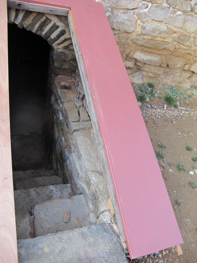
A. Removal of the porch and concrete cellar steps, retaining walls, and bulkhead side-walls ["cheeks"] revealed numerous original architectural details concealed by these massive 20th century accretions, including the flattened ["suppressed"] brick-arched cellar window [Image #1, photo #4855], and the arched cellar "doorway" [or "open-way" or "cellar-way" if originally no door was installed; Image #2, #4884 shows clay tamped to provide bearing layer for stone footings of the cellar staircase]; foundation-plinth joints have been re-mortared; bond-stones "toothed" from abutments will be joined to retaining walls.
B. Long, [temporarily metal-capped] outlookers [Image #3, #4905], supported the original second story balcony, which will be re-constructed after thorough research and documentation on appropriate form, materials, and railing and baluster details.
C. Image #4, #4914: Photo of west gable wall and south eaves wall after 20th century porch-rafter pockets have been filled in with stones found on the site and woven into the "random rubble" walling pattern; mortar joints recessed ["set back"] for future pointing.
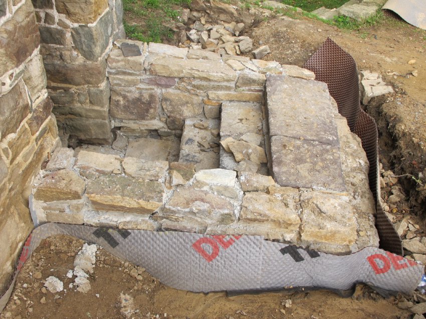
D. Most of the Trust's restoration work in August has consisted of construction of retaining walls and steps to the cellar under the western portion of the 1753 house. A woven, relatively non geo-degradable polymer "mesh" was inserted between the foundation plinth and the reconstructed walls as a clear demarcation between the new stonework and the original masonry [Image #5, photo #4952]:
Image #6, #4990: cellarway retaining walls under construction [20th century concrete steps to left]; stones came from porch piers and back-walls of concrete walls at cellar-way, and had probably been previously used in the retaining walls flanking the early cellar entry. Stones are laid out in yard to facilitate selection and masoning for position in walls to optimize the long-term integrity of the re-constructed wall. Tread, riser, and "run" dimensions and proportions were calculated and installed as shown in the accompanying photos.
Image # 7, #5042: tread-stones, with staggered vertical joints, are anchored by being "pocketed" a few inches into adjacent retaining walls.
The 20th century concrete steps had projected six feet farther south (toward the barn) than the stone stairway constructed in the traditional manner, structure, and proportions.
Image # 8, #5043: building up core with mortared "rubble" [smaller stones of irregular sizes and shapes] to support treads.
Images # 9, #5074: Tread-stone marked ["T5A"] for intended location at 5th tread level.
Image # 10, #5085, 8/5/11: integrated steps and side-walls half-way to upper landing elevation; shims set level for each riser and tread;
Image # 11, #5253: upper landing stones set at same elevation as retaining walls to provide level platform for future wooden "cellar-cap" [two angled "bulkhead"{a} doors and triangular board "cheeks"].
{a} a 19th century term for "cellar doors" [Carpenters Company Rules, or "cellar cap" [see Lounsbury, Glossary…, p. 53].
Images # 12 & 13, #5339 & #5334, 8/17/11: Retaining walls and upper landing leveled to receive doors, support-frame, and cheeks.
Images # 14 & #15, #5246 & #5256, 8/11/11: clay excavated from the site was manually raked and sifted; the few artifacts found were bagged and labeled.
Image # 16, #5397 shows rough grading along west gable wall and restored cellar entry area [right edge of photo].
The outer perimeter of the three-segment cellar-entry wall was waterproofed with mortar pargeting to establish a roughly single-plane vertical contour, coated with a liquid-application rubberized product, (Eco-Flex) [Image #17, #5290], and lined with Delta-Drain moisture-barrier/water-conducting membrane [Image # 18, #5295].
E. Cellar walls & steps at c. 1800-1820 addition:
Image # 19, #5319: excavation at cellar entry to c. 1800 addition; to the right is doorway to ground [also "root", "arch", or "cave"] cellar, with wooden "centering"{b} frame supporting the load above the entry opening during repair of failed brick arch.
{b}: "Centering" consists of timber form-work creating a braced [in this case by plywood "tympanum"] upon which the stone arch-ring voussoirs [slightly wedge-shaped stones often with a keystone at the arch-crest or "crown"] are set and "mudded-in" with mortar until the joint mortar cures, followed by the laying up of the wall superstructure borne by the arch spanning an opening. Image #20, #5400: laying out footings and base-stones for steps/treads and rubble core.
A construction-detail drawing and several photos of the as-built staircase into the addition appear in archive record KR11FN2.
George Douglass House and additions:
The brick re-paving of the Douglass-Leaf store-yard will be completed in August or September using the 19th-century paving bricks found in Morlatton Village. [Note: several areas of original stable brick paving were left undisturbed, and replacement brickwork was woven into the old pattern]”. The varying brickwork patterns found under the concrete slab [Images #21 & 22, photos #4010 & 4011] provided guidance and a template fragment in the re-paving process.
The roof-extension hood over the three doorways in the SW corner of the yard is progressing: treated vertical board sheathing has been installed on the half-gable [Image # 23, #5540]; floor boards have been laid in the loft over the hooded area [Image #24, #5549].
Image #25, 7/1/11 construction-detail drawing of brick store-yard re-paving [GDH store yard paving].
The stone paving under the roof drip-edge has been set on grades modified to shed water away from the buildings and store-yard.
Requested Board action:
1. Approval of continuation of masonry stabilization and restoration of GDH buildings, including the unstable gable wall of the late one story "slaughter house", and walling-up of two non-period windows in the south gable wall of the Douglass federal-period store addition.
2. Transfer of the George and Janice Wolfe fund to the Shelley account in recognition of double-matching Shelley grants toward restoration of the Douglass complex.
3. Initiating a funding campaign for the restoration and preservation of the Keim house and ancillary building, with double-matching support from the Shelley Pennsylvania German Heritage Fund. Approval of the funding flyer for editing and layout.
Submitted by the Sites & Structures Committee, Laurence Ward, Chair; Updated November, 2016
Sites & Structures Committee Report for August 14, 2013 meeting of the Board of the Directors of the Historic Preservation Trust of Berks County
Description:
The following is a summary of stabilization, preservation, restoration, and related work planned, completed, and in-progress, including requested Board approval or other action on pending work and projects under consideration:
White Horse Tavern:
I. Masonry Stabilization:
A. Utility-line and duct holes in cellar bearing walls were recklessly cut much larger than necessary during 1970s restoration and subsequent utility retrofits, jeopardizing structure;
B. A wall crack inside kitchen door [[Image # 10, 8/9/13] was caused by void in support piers directly below it and subsequent further displacement of stone units from soffit of rough opening. Repaired Aug, 2013.
C. An undersized and inadequately supported "lintel" spanning the passageway between the front and back cellars [under the doorway between the two first-floor rooms] is supported on the north only by a 4" block wall remnant, is deflected not bedded in the stone jambs, and ineffectively shimmed. Structurally stabilized August, 2013.
D. Significant joint and bed mortar in exterior and interior stonework has disintegrated, from moisture incursion and possibly rodent intrusion in some areas.
S&S remediation proposal [Shelley funded as urgent and necessary structural stabilization]:
(1) close voids completely with masonry in-fill where no pass-thru is necessary (two critical void areas have been addressed and remedied) ;
(2) consolidate masonry around minimum-diameter opening required for piping, ducts, and electric lines, leaving only sufficient opening for future conduit [Image # 11, 796, 8/9/13].
(3) Eric Hansen will shore the floor loads to relieve the temporary "lintel" until a permanent solution is implemented.
(4) Masons will deep-point exterior voids, and fully pack, plug and point interior problem areas, primarily in kitchen-hallway [exterior wall of early addition].
II. Winterization
A. Attic Insulation. [Materials Shelley funded]; labor estimate, from general funds, $400.
Review Frank's proposal re his attic, electric bill, split meter, etc.
B. Storm door[s], windows. [Materials Shelley funded]; labor cost unknown;
C. Heating oil bids to be obtained; need Board approval for COD terms for best price, or automatic delivery @ higher price.
III. Electric service proposal:
1. Move meters and cables underground from building to new pole and to existing panels from cellar. Waiting for estimate and Met Ed requirements.
2. Separate apt. meter.
3. Same program for GDH?
IV. Paint WH entry steps and porches;
volunteers or paid painters? No grant funding available.
Keim House: A. Pent roof and balcony: Work has begun on repairing and consolidating balcony joist-extension ["outlookers"]. New joist cantilevers will be lap-joined and screwed to ends of original outlookers.
B. Removal of the 20th century box cornice confirmed that the original cornice was a plastered cove cornice, as appeared to be the case in the vintage photos in archive record #KHPH9. Lainhoff photos sent separately.
George Douglass House: A. The mortar-plaque "Datestone", framed in a vernacular aedicule, appears to say 1765, NOT 1763 [Image # 1, photo 3062, 7/17/13]. It also states the owners’ incised initials: “G[eorge]” and “M[ary]” “D[ouglass]” and several symbolic motifs. The plaque continued to decay and several pieces became detached by 2020. They will be consolidated and the tablet will be re-integrated by Museum quality conservation.
B. Window work 90% complete. Window frame above front door will be squared. July S&S committee meeting at GDH, consensus to level top edge of shingles of reconstructed pent roof with bed joint under truncated and deflected flashing course as closely as practicable [Image #2, photo 3104, 7/23/13] shows level string-line along object-plane].
Mower: Paul has been coping with overheating and steering problems, which are too expensive to repair- might last this season, not much longer.
Suggest fund-raiser/in-kind donation campaign in Newsletter.
Mouns Jones Site Archaeology: Chapter 21 archaeologists have continued the project at MJH, focusing on examination of the sub-grade foundation and investigating artifacts and features on the river side of the house. Preliminary findings to date include:
1.Probes under the foundation stonework about two feet deep indicate that there is no cellar under the southern half of the riverside eaves wall [Image #3, photo 3186, 7/26/13]; a similar test will be made north of the existing door.
2. Two large quarry-cut blocks of limestone under the center of the river wall could have been the base- or bed-stones for the sill of the early centered doorway [Image #4, photo 113, 7/2/13];
3. Substantial segments of below-grade stonework in northern units exterior to MJH foundation [Image #5, photo 3121, 7/23/13].
4. Electric lines from MFH to MJH are buried about 4.5 feet from the river eaves wall [Image #6, photo 8/10/13, #3525].
5. A 24" thick below grade masonry wall segment parallel to the riverside eaves wall [Image #7, photo 8/9/13, #774] will be investigated to determine its form, extent, and purpose [possibly a foundation base]. Other masoned stonework, rubble, and river cobbles [Image #8, Photo 8/10/13, #3533] adjacent to, some apparently integrated with, the foundation are being photographed and measured for further consideration.
6. A 4 inch thick and solid stratum of reddish soil [Image #9, photo 8/10/13, #3538]- primarily clay, loam, and stone screenings (possibly floor "paving")- was uncovered west of the underground masonry wall. The extent of this material will be determined to ascertain whether it is bounded by a wall perimeter.
Morlatton Village Parking Areas:
Amity Township has requested that the Trust control the weeds in the gravel surfaces and around the log perimeter of the parking areas, in accordance with the License agreement. The weedy areas within the lots are being treated, the large poke-weed and ironweed "trees" are being cut or pulled where they intrude into the parking perimeter or conceal the logs, and the border outside the logs must be deep-raked to eliminate overgrowth covering the logs. Necessary materials are payable from Shelley Fund.
The White Horse lot weeds are under control. The two areas in the lower village need attention ASAP.
Board approval requested for volunteer or paid labor where necessary.
Weed control around buildings, poles, fences, trees: payable from general funds or rent credits.
Tree work: Dead oak/elm 25 ft. SW of MFH must be cut down; stump to be left in place. Three smaller trees in same area are either leaning or damaged and should also be cut down. The Trust would eventually recoup most of this in firewood value. Volunteers will cut the trunk and limbs to firewood lengths.
Low-hanging limbs should be cut from walnut tree SE of MJH.
Richard Brown [Rich, Jr.] will cut the trees down for his cost of $400.
Board ratification of email approval is requested to proceed with work and for appropriation of funds from general account.
Cottage Deck: Zoning permit approved; work substantially complete; Shelley funded.
Submitted, Sites & Structures Committee, Laurence Ward, Chair; Updated, Sept 2016 and November, 2020.
Sites & Structures Report for the February 22, 2012 meeting of the Board of Directors of the Historic Preservation Trust of Berks County
The following is a summary of preservation and restoration work completed and in-progress, with recommended Board action:
Keim House:
A. Cellar Doors and framing:
Installation of the cellar entry oak framing, and mahogany rake-boards and cheek walls is complete [Images ##1 & 2, photos 7477 & 7478].
The cellar doors and support structure will be painted and installed after hardware is fabricated. The light red color undercoat seen in Images ##1 & 2 is not the color of the proposed finish coat, which will be the darker "Spanish Brown" found on original wooden elements [shutter and balcony]. This color is well-matched by Benjamin Moore "El Cajon Clay", and is recommended for this finish by our paint consultant Matthew Mosca, and is very close to the color Dick Shaner used on some of the exterior elements of the south ["front"] eaves wall of the 1753 house in his earlier restoration campaign.. Image #11 graphically shows the incorrect color on the new cellar cap and the correct Spanish Brown color on the balcony, above-right. A sample of the correct color was presented at the Board meeting and the correct paint color applied as of August 20, 2015 [Image #12].
B. Cellar Window:
The original oak lintel (but not the jambs or sill) over the cellar window at the west end of the south eaves wall survives, with five hexagonal mortises in its underside [Image #9]. These holes, which were undoubtedly matched by five in the perished sill, originally held vertical wooden bars. This grilled frame will be re-constructed using the original lintel; the replacement jambs and sill will be fabricated with mahogany for moisture-resistance.
Morlatton Village Parking Facility:
A. Construction and License Agreements have been executed by Amity Twp and the Trust. Copies were forwarded to Board members and are available on request. We are required to appoint an administrator who will handle scheduling, notifications to the Twp and other parties, etc.
B. We have firm quotes on tree-work and excavation; perimeter log anchor grates, bolts, bearing plates, and fasteners; geotextile; base and top-course stone; log-support blocks; we will also supply the drill and bits for log-rigging [detail drawing attached; welded bearing plate will be replaced with adjustable threaded rod fastener and lock-nut under plate supporting the fiberglass grates].
C. Amity Twp personnel and equipment will: deploy the mulch berms and other erosion control materials; transport stone from the quarry; lay the woven base and non-woven separation geo-fabrics; spread stone courses, with assistance from the site contractor; and rig the anchored perimeter log system.
D. We will need volunteers to process and set posts along pedestrian paths and safety zones within the parking perimeters.
Douglass Floor Work:
Rotted floor joists were cut back to solid wood and scarf-joined to new timber extensions, glued and bolted through "birds-mouth" joint [Images #4 & 5, photos 7518 & 7530].
Original 1760s flooring nails were found throughout the northern rooms [Image #6, photo 7519].
Original floor boards [Images #7 & 10, photos 7523 & 7526] were exposed upon removal of flooring over-layment; these boards are of varying widths but in a narrow range, producing a more solid floor membrane, at greater expense than early floors with wider "random-width" boards.
Requested Board action:
1. consider providing a sheltering structure for the KH root cellar to preserve and exhibit it as a study-piece, after S&S committee consideration and recommendation of form and details. Current concept is corner posts, modern metal roof, winter closure. Drawing should be available for March meeting.
2. Procure and/or designate storage space for mission-related items to be permanently removed from exhibit areas and interpreted spaces.
Subject to security, environmental considerations and other important factors determined by the Board, the following areas are recommended for storage of appropriate materials and artifacts:
Fulp cellar and crawl-space.
Douglass ancillary addition loft.
Douglass smoke chamber??.
Keim addition cellar, and Keim barn.
White Horse cellar and second floor chambers.
3. Dispose of non mission-related and non-usable architectural items, such as shutters, window sash [after removal of early period glass], doors, etc., in conformity with policy adopted by the Board; completed in 2013.
4. Authorize the preparation of drawings [funded by grant sources] for the proposed KH pent roof and cellar-entry structures. Resolved in 2013.
5. Discuss and approve Lainhoff proposal dated Feb 8, 2012 [previously forwarded] for work at Douglass, Keim, and DeTurk.
6. Authorize PHMC grant application for Douglass projects, including current proposals in Feb 8 proposal, and proposed additional work for which approval is sought subject to receipt of sufficient grant funding.
7. Approve March 31 requested date for Pete Nugent dinner event and communicate guidelines to him.
Submitted by the Sites & Structures Committee, Laurence Ward, Chair; updated Sept 2016 and November 2020.
Historic Preservation Trust of Berks County Sites & Structures Report, 3/12/14
MOUNS JONES HOUSE RESTORATION:
As reported at the last meeting, it has become obvious from close inspection and measurements that the central segment of the masonry wall facing the Schuylkill River is distended from a vertical alignment by as much as 6 or 7 inches. The "bulge", visible on inside and outside surfaces of the wall, covers about 325 square feet between the blue lines on the attached Image #1, showing the displaced wall area outlined in blue.
The contour lines on the drawing [Image #2-"bulge"diagram] show the extent and shape of the deformed area, structurally a radial "membrane" in unstable tension and stress. Measurements from the plumb grid-plane suspended from the rafter-tails (Image #3) show that the dislocations are 6 to 7 inches at the extremities, rather than the estimated 5 inches shown on the drawing. The slowly but measurably disintegrating wall masonry has moved several inches away from the floor-boards since the 1965-70 restoration [Image #4, daylight through widening gap]. Based on this disparity, there is also the possibly of de-lamination and rubble-disintegration within the wall-mass.
The 2014-2019 restoration campaign will dismantle, reconstruct, and stabilize the river-side façade-wall and restore the door and window designs, fenestration forms to their 1716 locations and materials, and, to the extent compelling evidence provides the essential details, the type and operation of the authenticly re-fabricated windows, achieving four important objectives:
(1) Reconstruction of the deformed and structurally unstable segment of the wall, re-placing each stone "unit" in its original location (where determinable); {a}
{a} During de-construction of the unstable wall ranges, it became apparent that a significant quantity of the stones making up the wall had fractured or become degraded, or were too small and misshapen for a well-bonded wall, and that the surviving mortar residue was often "friable" [coarse and in-cohesive]. These conditions, coupled with poor bonding and careless integration of the stone units, rendered it unfeasible and imprudent to re-set stone units in their original locations in the walling-pattern.
(2) Restoration of the proper plumb alignment and re-establishment of stable bearing-compression between the foundation, restored wall planes, and the rafter plates supporting roof loads;
(3) Restoration of the doorway from its 19th century location in the northern bay to its documented original site, roughly centered under the 1716 date-stone; and
(4) Fabrication and installation of a new door and windows in their original locations, as delineated in the masonry evidence beneath the interior 1970 plaster coatings.
The shoring system designed in concept by Trust volunteers was professionally engineered to ensure that roof loads, scaffolding, materials decks, and compromised wall margins will be safely supported and stable during the project.
KEIM HOUSE RESTORATION:
The details of the balcony railing have been worked out. Drawings of the balcony elements and kitchen-entry structure will be provided before fabrication. The pent roof framing [Image #5] will be covered with Oley Valley type clay tiles with appropriate exposure and lath spacing coordinated with the sizes of local tile units. {b}
{b} The clay tile finish was a late change [from German side-lap shingles] based on compelling evidence [including century-old photographs] that the original roofing of the 1753 house was tile-on-lath.Federal-era addition shutters have been consolidated or fabricated based on surviving originals [Jan 17, 2014 Lainhoff report]. Conservation of windows and door frames was completed in 2013.
GEORGE DOUGLASS HOUSE:
Nine pairs of shutters will be fabricated for the 5-bay 1765 house-block.
Laurence Ward, Updated: September, 2016, Oct. 2016, October 2020
Sites & Structures Report for October, 2011 to Directors of the Historic Preservation Trust of Berks County.
The following is a summary of preservation and restoration work completed and in-progress:
George Douglass House, The early 19th century second addition:
Re-construction of the gable wall of the one-story summer kitchen/meat processing structure, will be complete by the end of work Tues Oct 25 (see Images #1 & 2, photos 6603 & 6117, 9/16/11), except for pargeting and plastering the interior, which will be deferred until exterior masonry stabilization is performed on the Keim "root" cellar while the weather is warm enough for mortar.
More than half of the pre-restoration gable wall structure had been deformed and de-stabilized by the numerous disturbances inflicted when doorways{b}, windows, bake oven masonry, and timber alterations were created, removed, modified, or walled-up. Only the western third of the lower wall was sufficiently stable and plumb to remain. The dismantled gable wall was re-laid to reasonably conform to plane-alignment provided by the original corners at grade and the outside faces of the end rafters. Both corners at grade are south of the vertical plane of the rafter faces. The eastern "quoin" corner foundation is approximately 4" north of the western corner, using the rafter faces to establish the inclined plane ["batter"] from the rafters to the ground. These unavoidable departures from a "plumb and true" wall-plane produced a slight vertical camber near the center of the re-constructed wall's exterior face, and a four to six inch batter from ground-level to the rafter faces.
{b} [Image #3, photo #4204 shows the 20th century freight door and the vertical jamb-seam of an earlier doorway, external clean-out sump, and failing corner pier.
All segments of the reconstructed wall are strongly bonded and substantially closer to a common plane than they have been for decades, resulting in exponentially greater structural stability.
The fireplace and most of the chimney stack had been removed after 1930 {a}, probably when the large freight door or its predecessor to the west [both now walled-up] was cut through the east bay of the lower wall range.
{a} See Image #4, photo #12, 3/3/19, a c. 1930 image showing surviving chimney on right-end gable [Click on photo for full image]..
Charred stones removed during dismantling of the upper chimney-back have been re-laid in the same interior wall segments from which they were removed. Bond stones were cantilevered in the same jamb alignment as were indicated prior to de-constructing the wall [Image #5, photos #6612].
The small window opening in the east segment of the upper gable of the one-story structure, which had been closed-up when a retrofitted beam was bedded on its stone sill, has been delineated in the re-built exterior stonework [Image #6, photo #6606, 10/22/11].
Remnants of the brick arch of an external oven, closed-up with bricks when the oven was removed in the middle third of the 20th century, will remain exposed in the interior wall as evidence of the early baking structure [Image #7, photo #6309]. Charred stones in the wall core [Image #8, photo#6318], top center, above the opening through the wall and in-filled brick arch are evidence of the "squirrel tail" flue [removed in 20th century] from the oven into the smoke chamber of the large cooking fireplace.
Remains of the oven's foundation were found under the external stone well which probably served as a wash-out sump for the meat processing activities which continued into the 20th century.
The outlet was fed by a drain piped below floor level through the wall.
1765 George Douglass House:
Plywood has been applied to close-up the rear [east] doorway after a night-time attempt to enter the house during the weekend of Oct 15.
DeTurk Multi-Function "Ancillary" building:
The replacement board-and-batten kitchen door has been fabricated and installed.
Keim House:
The balcony door frame has been consolidated, repaired, and joined to the new wooden sill. A replica of the "chevron" door onto the balcony has been fabricated for installation. The original door will be preserved and exhibited.
Douglass, Douglass-Jenkins and "Amity" Store Ledgers:
The six store ledgers and two Brinton Civil War paymaster ledgers held for safekeeping at St. Gabriel's Church for the past 25 years have been returned to the Trust. The Board should determine a secure and environmentally appropriate location for the store ledgers.
The Civil war ledgers are not within the Trust's mission and could be sold or donated to a qualified repository along with the balance of Brinton's books and records stored in the GDH attic for decades, or donated to a qualified repository.
Paint Analysis:
Matthew Mosca, with the ladders and assistance of our carpenters and consultants Tom Lainhoff and Chris Lainhoff, spent the day of Oct 18 [until dark] taking paint samples from wooden elements of the Douglass complex [all three structures], Keim House, [all three structures], and DeTurk House [selected elements]; see Images ##9, 10, 11, and 12, photos ##6550, 6551, 6557 & 6571. Matthew will provide a report on each site, with micro-photographs showing all paint layers and the wooden substrate in each sample. This process will quite probably furnish a specific color match to the original finish from each element. Some of the samples were very fragile, but this process should give us authentic historic colors for most [possibly all] of the wood finishes sampled. Wooden surface not originally painted (based on a determination of color-dating and the presence and quantity, or complete absence, of particulates on the un-painted substrate) will be analyzed for later-period finishes.
Morlatton river-front buildings:
In addition to projects reported previously, the following work has been completed through October 24:
Replacement of the barge board and fascia on the Fulp house.
Requested Board action:
1. Arrangements for disposal of various containers of hazardous waste at the free November 5th event.
2. Authority to shred old records and insignificant documents.
3. Authority to sell or donate Brinton civil war records and books.
4. Designation of authorized storage space for mission-related items removed from preserved, exhibited, and interpreted spaces.
5.Volunteer for Nov 5 tour of DTH & KH by PA Archaeology Chapter 21
Submitted by Sites & Structures Committee, Laurence Ward; updated Sept 2016, November 2016 and November 2020.
Sites & Structures Report for October 9, 2013 meeting of the
Board of the Directors of the Historic Preservation Trust of Berks County.
The following is a summary of stabilization, preservation, restoration, and related work planned, completed, and in-progress, including requested Board approval or other action on pending work and projects under consideration:
I. White Horse Winterization:
A. Attic Insulation in progress [original 1765 Tavern only];
B. Interior [façade and gable-ends] and/or exterior storm door & windows;
C. Heating oil bids status?
II. Electric service project , to move Tavern & Douglass electric cables underground:
A. Township permits pending;
B. Locust posts and mounting frame for meters and disconnect panel [Image #1, Elevation sketches attached]; See as-built photos and perspective drawing, Images ##8, 9, & 10.
III. Paint project for WH entry steps and porches: Frank is ready for color selection.
IV. Keim House: Pent roof, balcony, kitchen entry structure, and cove cornice:
A. Repair, consolidation, and extension of balcony and pent roof outlookers substantially completed [Image #5, Photo 4626].
B. Proposal:
(1) Pent roof covering material:
Option #1: "hipped" pent roof covering is conventional sawn western red cedar shingles, 32" lengths, 10" exposures, 5/8" butts, 4"-8" widths, no interlayment, mitered at return joints. The hip pitch and rafter alignment, closely symmetrical at both ends of the pent except for a few inch differential in flashing over-hang, are indicated in attached Image #2, photo #4697.
Option #2 selected: after further research, and consideration of the photographic evidence of clay tile covering on the early-period roof [Image #11], the decision was made to install tiles on lath to cover the pent roof, with round-form cap tiles on the hipped-return joints.
(2) Since there is no current evidence of stone piers or footings [after archaeological excavation], the current plan is to support the entry stair [open-riser "step ladder" type] and stoop/landing on wooden posts, somewhat like the Pool Forge entry in Image #3, photo #4659 attached, but without hood-support posts or benches.
(3) The balcony surround will also include simple, possibly beaded, board rails with corner posts. The outlookers, fascia, and temporary flooring are shown in Images #4 & 5, photos #4621 and 4626.
(4) All of the new woodwork on both levels will be painted with the "Spanish Brown" color determined by Matt Mosca to have been the earliest finish on window frames on the 1753 house.
(5) The coved plaster cornice [1753 house only] to be restored on old re-claimed lath nailed to the original coved joist ends [Image #6, photo #4140]. The cornice on the addition was obviously not contemporary with the house and will be stabilized in its current 19th century "box" form and considered for future restoration. Image #7, photo #4618, shows the restored outlookers, rafters, rafter plate, and original flashing course for the re-fabricated pent roof on the 1753 Keim house.
(6) The 2013-14 and future projects funded by the Shelley account will be limited to the original1753 house, except for structural stabilization and weatherization, which will be eligible for matching grants..
V. Mouns Jones Site Archaeology:
A. Propose winter-time interior excavations and examination under wall plaster to locate stone joists/piers & other structural features, possible artifacts, and seek evidence of central doorway location and masonry alterations.
B. Possible cellar wall [earlier log house?] exposed by Chapter 21 archaeologists in Unit 13, about 5-6 feet from MJH doorway.
VI. Morlatton Village site work: Hazardous trees behind MFH have been cut down and partially cut to length for firewood.
ACTION REQUESTED ON: I-B & C; III; IV-B; and V-A.
Submitted, Sites & Structures Committee, Laurence Ward, Chair; Updated November, 2016 and November, 2020.
This panel will distribute and meter electricity to the Tavern underground, removing the modern intrusive wiring and appurtenances from the walls of the building. The board-face of the mount structure will be screened from the road by appropriate plantings, except when used for event and activity posters as convenient.
Laurence Ward, Nov. 2013 and November, 2020.
Sites and Structures Reports · September 2013, November 2020
Sites & Structures Report for September 11, 2013 meeting of the
Board of the Directors of the Historic Preservation Trust of Berks County
The following is a summary of stabilization, preservation, restoration, and related work planned, completed, and in-progress, including requested Board approval or other action on pending work and projects under consideration:
I. White Horse
A. Masonry Stabilization:
Substantially completed per details in Aug. report: wall-voids and support-pier voids closed up;
bearing walls consolidated & mortared-in; utility conduits set.
Change in material:
Failed cellar passage lintels have been replaced with pair of re-sawn white oak lintels (instead of a steel header), pocketed in the fireplace support wall and bedded on the bearing pier south of the opening Image #1, Photo 4081, 9/11/13.
B. Winterization: Attic Insulation and interior storm door & windows: details at Oct meeting.
C. Heating oil bids should be obtained: refer to Finance Committee or volunteer?
II. Electric service proposal:
Move meters from building to remote panel box and lay cables in conduit underground to existing [WH], or new [GDH] panel; meters and disconnect to be within 10 ft. of pole; Electrician's estimates:
A. WH…$2900: including isolating apartment electric to existing 100 amp meter. All HPT service from existing 200 amp meter.
B. GDH…$2025.: new 100 amp service, underground from pole off R/W, across cellar to new panel at rear stair landing at kitchen level;
limited interior distribution wiring for construction equipment, temporary lighting, etc..
C. Excavation, disconnect, and meter base frame not included.
Waiting for Met Ed requirements.
Would need design for wooden frame/box to shelter meters, etc. [photo of private Oley site concept attached (not acceptable for Morlatton, but a rough idea of scale, etc.)].
III. Paint project for WH entry steps and porches: volunteer[s] needed to coordinate with Frank, select color, repair treads, etc.
IV. Keim House: Pent roof and balcony:
A. Work has begun on repairing and consolidating balcony outlookers. New joist extensions have been lap-joined and fastened to truncated ends of original outlookers. Pent roof outlookers have been joined to truncated 2d floor joists [Image #2, Photo 4126, 9/11/20, Note the original flashing course above, which provide the ambient elevation for the top course of shingles]. Details of slope, railing, balustrade, etc. are being developed, based in significant part on the pent roof on the north façade of the house [Image #3, detailed and dimensioned field notes sketches including original outlookers].
B. Incorrect window frames on west gable end of original 1753 house will be consolidated, but replacement deferred pending determination of priorities among projects.
V. George Douglass House:
A. Mortar in-fill substantially completed around restored door and window frames, pending re-pointing program.
B. Restoration of front ["best"] parlor flooring, using maximum quantity of original floor boards) and partition wall at north gable-end under consideration and detail development-Shelley funded..
C. Restoration of back-parlor flooring at north gable-end deferred pending priority sequencing among other projects.
D. Shingled pent roof specifications and functional alignment with truncated outlookers and flashing course under consideration and detail development. Approval needed for re-creation of pent roof-Shelley funded.
VI. Mouns Jones Site Archaeology:
Consider winter interior excavations to locate stone joists-piers & other structural features, possible artifacts, and possibly confirm central doorway location-October agenda requested..
VII. DeTurk House:
Stonework above NW plate-tie has further deteriorated, but is structurally stable; NE tie also needs remediation-same program:
A. Consolidate tie and wall plate end-timber with wood epoxy and re-lay stones above tie; or
B. Replace tie with re-sawn white oak and restore masonry above tie; join ties and wall plates [recommend deferring this because of other funding priorities].
C.(1) End-out rotted wall plates to provide solid timber for joint with tie, or
(2) consolidate with epoxy.
D. Estimated cost: $2500. [Shelley funded].
Recommendation: "A" and C (2) as temporary preservation and stabilization measures pending allocation among higher priorities and less urgent projects.
VIII. MV site work: trees have been elevated above mower height and brush removed.
IX. Keim Cider Press Shed roof: deteriorated beyond repair; should probably schedule replacement for 2014; possible opportunity to purchase shingles sooner if can piggy-back on truckload [possibly from Brit. Columbia based on price and quality] this Fall?
ACTION NEEDED ON:
I (C) II III V (B) V (D) VII (A)VII (C)(2)IX
Submitted, Sites & Structures Committee, Laurence Ward, Chair; Updated Sept 2016, Nov 2020.
Sites & Structures Report for the March 28, 2012 meeting of the Board of the Directors of the Historic Preservation Trust of Berks County
The following is a summary of preservation and restoration work planned, completed, and in-progress, with recommended Board action:
Keim House:
The committee is considering the following projects:
A. Re-establishing the open cornice and exposed rafters on the ancillary building;
B. Re-constructing the pent roof on the south eaves wall of the 1753 house;
C. Re-constructing the second floor balcony on the existing original outlookers;
D. Re-constructing the steps and entry-landing at the first floor kitchen doorway.
E. Restoring the cellar window in the western end of the south eaves wall foundation, using the surviving original lintel and jamb-parts.
Findings and recommendations to be submitted by this committee for Board consideration will address the appropriate materials, form, and detailing of these exterior structures.
The replacement frame for the cellar doors and framing [later "bulkhead"] sheltering the cellarway stair has been installed [Image #1, photo # 7434]; the beaded raking boards and triangular side-walls ["cheeks"] were joined to the frame, using traditional pegged mortise-and-tenon techniques. The exterior of this reconstructed stairwell covering ["cellar cap" in the 18th century] will be painted with modern paint matching the 18th century naturally pigmented "Spanish Brown" color determined by photo-micrographic analysis to be the earliest paint finish on the exterior woodwork of the 1753 house. The authentic color is a close match to the reddish brown on the first floor doors and other exterior woodwork.
George Douglass House:
Work has begun on stabilizing and consolidating the joists and floor boards of the center passage ["hallway"] of the 1765 house. Rotted joist segments have been cut away and will be projected to the bearing pockets in the masonry walls with re-cycled white oak extensions joined to the remaining solid timber by means of compound "scarf joints", an authentic 18th-century technique [Image #2, photo 7516 shows hallway joists stabilized by this method]. The majority of original floor boards remain in place in the two north parlor spaces [Image #3, photo 7538], still fastened with original wrought-iron flooring nails [Image #4, photo 7520].
Grant applications have been submitted to fund repair of the parlor flooring and additional structural work. Additional funding will be required to proceed with other essential structural-integrity and restoration efforts, including moldings and other woodwork in the center passage and principal staircase.
Carpenters have begun to re-install interior woodwork in the early mansion, using molding profiles and other millwork found in the attic and elsewhere in the house.
The door frame centered in the principal "Georgian" [front] elevation of the 1765 house has been repaired with "Dutchman" dimensioned timber extensions scarf-joined to the surviving original upper jamb segments. The re-installed frame has been primed with a close match to the 18th century "lead white" color found in samples taken from original exterior woodwork and analyzed by Matthew Mosca, the Trust's Historic Paint Finishes consultant [Image #5, photo 7642]. This color is the authentic period color for the restored exterior woodwork.
The disintegrated masonry under the stone sills at the two aligned doorways will be stabilized and built up to support the extended joists in their bearing sites in the foundation wall. The sill from the front doorway is missing, removed or destroyed when the concrete "threshold" was installed in the early 20th-century. A replacement sill-stone will be set in the opening, butted against the joists under the center passage/hallway and pocketed into the stone abutments flanking the doorway.
The three-part composite lintel ["jack-arch"] spanning the primary doorway has become de-stabilized and the two canted support-stones and "keystone" have rotated and suffered short fractures. The wall-span above the lintel will be consolidated, re-bedded, and re-mortared, and the three segments of the restored "flat-arch" will be aligned closer to a level setting. The restored wooden frame will then be fitted together with pegged mortise-and-tenon joints and set as a structural unit within the "re-squared" masonry opening.
The two-piece sill at the rear [eastern] doorway was re-installed and re-aligned in 2011. The upper foundation bearing the sill will be re-laid to support the joists at the levels established by the structural jacking process undertaken in the 1990s, and the flooring at both doorways in the central passage will be completed.
"Amity" Store Addition:
Non-period partition walls and plastered ceilings have been removed from the c. 1798-1810 "Amity" store addition to the 1763 Douglass house [Image #6, photo 7659], exposing original joists, summer beams, and the plastered wall-spans in the joist-bays [Image #7, photo 7687]. Joists visible in the first floor "public" store space have finely beaded edges ["arrises", Image #8, photo 7717] along the meetings of the horizontal and vertical surfaces of the beams. The joist-edges in the functionally non-public second floor storage warehouse are un-beaded and un-chamfered.
The quarter-round edge-bead which had refined the summer beam overhead in the first floor store was cut off to provide a level nailing- plane for lath when the ceiling was plastered and the store transformed to domestic usage. The profile of this classical "ovolo" detail is visible where the beam enters the plastered wall.
The doorway between the c. 1798-1810 store addition and the adjacent southwest [front] room of the 1763 house has been re-opened. This doorway had been converted to a closet and appears to be the original means of communication between the "house" store, which was possibly located in the front room now adjoining the store, and the discrete building attached to and architecturally extending the house [Image #9, photo 7649]. No record has been found as to the precise location of the Douglass store which commenced mercantile activity in the mid-1760s.
According to Douglass and Douglass-Jenkins "Amity" store ledger books and records in the Historical Society's archives, the mercantile venture had been conducted in the house for at least three decades before expansion into the addition structure fully devoted to storing and selling merchandise.
Removal of a plaster patch above the access door inside the second story revealed brick in-fill, almost certainly installed to close the rectangular opening which had lodged the cantilevered timber "outlooker" which supported a pulley for hoisting goods into the storage space [Image #10, photo 7695]. The practical commercial purpose of the un-partitioned second floor warehouse becomes more evident in its restored condition Image #11, photo 7690].
Some joist-tenons have become partially disengaged from their mortise-pockets in the summer beam [Image #12, photo 7660]. This lateral displacement could have been caused by the settlement of the store addition into the clay bed after completion of the structure. Evidence for this includes the 1" differential (lower alignment of store beds) between the horizontal mortar beds of the 1765 house and those of the store-block [Image #13, photo #8388, 11/6/13, and Image #15]. A similar disparity between the mortar beds in the 1764-5 White Horse Tavern [Image #14, photo 5471, 6/22/15, attached] and its Federal-era addition strongly suggests that the builders of both additions, built within a year or two of each other, failed to take into account the compressibility of the clay sub-strate supporting the foundations of the added structures, causing them to align the beds with the earlier 1760s structures. Pending investigation of the possible structural causes of this movement, including transverse shrinkage of the "green" summer beam, attic tie-beams between wall plates, collar-ties, or other means of restraining roof-thrust will be considered to stabilize the attic floor framing system.
Johan [John] DeTurk House Archaeology:
Mapping the existing (probably late 19th century) brick paving on the earthen floor in the lower level kitchen of the DeTurk ancillary building was recorded by tracing the brick-joints on clear acrylic sheets on March 18, 2012 [Image #16, photo 7680]. Five-foot square grid "units" were plotted and lined with string on March 25, and excavation began in the unit close to the passage doorway to the root cellar [Image #17, photo 7862]. The "dig" is being conducted by Chapter 21 of the Society for Pennsylvania Archaeology, which will resume the exterior archaeological project at the Mouns Jones House after completion of the DeTurk kitchen-floor work. Artifacts and other features found in these processes will be catalogued, photographed, and their depths and grid-locations recorded.
Mouns Jones Herb Garden:
Work to begin this spring on restoration of the garden, which had been severely damaged by several floods within the past five years, will include re-installation of brick paving and edging the raised herb beds with non-buoyant and rot-resistant materials [sketch of proposed non-period restoration attached, Image #18].
Morlatton Parking Areas:
Tree-removal work began on the Morlatton Village Parking project on March 26th. The parking, driveway, and pedestrian pathway locations; base and surfacing materials; log containment perimeter; and other specifications are based on the location of the site within the Schuylkill River flood plain, the sound clay sub-base below the sandy, coal-silted topsoil, and a resolution to preserve the natural and historic setting to the greatest extent possible. The project is a cooperative effort among the Historic Preservation Trust of Berks County; Amity Township, Berks County; Brian Boyer Engineering; and Hopewell Nursery, Excavating & Trucking Co.; and is funded principally by grants from The Shelley Pennsylvania German Heritage Fund and the Schuylkill River Greenway Association and its contributing partners, and by in-kind contributions by Amity Township. See record numbers HPTSSR10, 11 & 13 for narrative and photos of the parking area construction project.
Surplus Material Sale:
The Trust will conduct a sale of doors, shutters and other early architectural items not related to its structures or mission. Those interested in purchasing such material are asked to contact the Trust's office by phone, email, or through the website at historicpreservationtrust.org. All proceeds will be applied to the preservation of structures within the Trust's custody and mission.
Skilled volunteers are needed for the following projects:
A. Woodworkers to create post-and-rail fencing for pedestrian paths and safety zones in the Morlatton Village Parking Facility. The Trust will supply the locust-wood material.
B. A "plumber" to cut and re-assemble drain lines, check valves, and outflow elbows at Trust flood-plain sites.
Requested Board Action:
1. Ratify the construction and materials-purchase contracts related to the parking-area project. Final materials costs are dependent on conditions and dimensions found upon excavation, and will be reported to the Board in future emails.
2. Authorize the preliminary planning for the Keim and Douglass projects outlined above, and the completion of work-in-progress, subject to funding availability.
3. Authorize this committee to select non-mission artifacts and other materials for sale, retaining Trust-site related items, and period items appropriate for research and documentation of early materials, means and methods.
4. Authorize periodic donations to the archaeology organizations working at DTH and MJH.
5. Seek volunteers for assistance with Trust projects.
6. Consider submitting the substantially completed MFH project for PreservationPA recognition.
7. Reply to Nancy Keim's request that the Trust participate in restoration/preservation of the Keim family cemetery.
Submitted, Laurence Ward, Chair; Updated October, 2016 and November, 2020.
Digital image of Keim House from original photographic print showing south elevation. Original structure includes two 2d story windows at left, balcony door above original kitchen door [center], chimney, and other original architectural details concealed by 1930s porch.
Original HABS caption for the image is as follows:
"Historic American Buildings Survey, Cervin Robinson, Photographer September 1958 SOUTHEAST ELEVATION."
Data sheets for HABS images (KHPH6 thru KHPH8--1002.01.025, .026, & .027) associated with the Keim House appear in MULTIMEDIA LINKS or see Archive record KHTX5--1002.01.028.
Laurence Ward, March 2021
The caption to image #1 as it appeared on page 2 of "American Folklife," (Vol. II, No. 5, February, 1974) the quarterly of the American Folklife Society, published by Richard Shaner, states in part: "This early photograph of the Lobachsville Keim Manor{1} house was taken in 1912 by the Reading Eagle. The couple on the extreme right are Mr. and Mrs. Shade, reporters for the Eagle, the other people are from left to right Samuel Bigony, Mrs. Robert Bigony, Glenn Bigony, and Mrs. Emma Campbell. Note the clay-tile roof on the original Manor [1753 farmhouse], with its excellent masoned brick central-chimney.…" The chimney, with Germanic Renaissance corbeling, quite pronounced in the upper courses, is set on a stone chimney stack rising through the attic to the cord across the span between the outside of the masonry jambs [Image #4, photo 003, 4/22/16]. The exterior brick chimney projecting through the roof ridge is aligned vertically by the flues it encloses and is inset on the stone base in the attic, choked down to the desired horizontal dimensions above the roof-planes.
{1} not literally a “manor” house, which from Medieval times was typically owned and occupied by a Lord of the Manor, who had legal authority to preside over a Court dispensing various aspects of legal recourse and remedies [see A Dictionary of Architecture by James S. Curl, Oxford University Press, 1999, p. 407, column 1]. A closer (conceptually and geographically) colonial analogue to the English “manor” would be George Douglass’s lands and stone house 10 miles to the south, where both George Douglasses, father and son, engaged in several commercial ventures, including iron trading, ownership of a wayside Tavern (the White Horse) and a “country store”, and both served as Justices of the Peace for the region in the 2d half of the 18th century.
Image #2 was taken in 1897, according to the caption accompanying a halftone print of this photo originally published in "The Keim and Allied Families in America and Europe" (1898-99) by de Benneville Randolph Keim, and reprinted on page 11 of "American Folklife," Winter, 1976, which in the accompanying text material identifies the individuals in the photo and mentions details of the "German colonial interior" of the 1753 house.
The text also notes that the "older portion" [two long bays to the right, with off-center chimney] "was erected in the summer of 1753 by “Irish” {2} masons brought in from Philadelphia" [reputed source: Moravian records]. A halftone of this photograph was also published in the essay "Keim Bakehouse Discovered" by Richard Shaner cited in archive record KHTX10--1002.01.050.
{2} During the re-stabilization of the south foundation wall of the 1753 farmhouse in 2011, the masons found a 1723 “Hibernian” coin in a mortar bed, probably having fallen into the mortar during the mixing process, and possibly depriving some poor lad of his beverage funding for the evening.
Image#3: Keim House, Southwest Perspective, after removal of 1930s porch and restoration of pent roof, wooden cellar cap over stone steps, and balcony above kitchen entry.
Note the absence of a porch or evidence of a porch structure or flashing course on the west gable wall in either photograph. This documents the hypothesis that the recently removed (in 2011) porch was not in existence during the lifetime of Betsy Keim, the last surviving Keim family occupant of the farmstead who died in late 1911; see archive record KR11PH3 regarding the history of the south pent roof and the two successive porches on the south eaves walls. As confirmed by a c. 1930 photograph taken by Amandus D. Moyer [see record #KR11FN1], there was no porch along the west gable wall as of the date of that photograph. Based on the c. 1930 Moyer photo and the 1941 HABS photo showing the porch along the south eaves wall and extending across the west gable-end, the "L" shaped porch [removed in 2011] was constructed between those dates.
Close scrutiny of form and alignment of roof covering material suggests the probability of a clay tile roof, as is seems quite clearly discernible in Images #1 & #2. This inference is also supported by oral tradition: William Parker, a farm hand and resident at the Keim farm in the late 19th century, and a frequent visitor there until the death of Betsy Keim in 1911, told an old friend and Oley Hills neighbor John E. Eshelman during a 1940s visit to the property "Why the old red tile roof ain't on the house no more"{a}, indicating that the tiles had been removed between 1911 and c.1940. Parker also indicated that the "new owner" [Mahlon Boyer and his son Charles Boyer owned the farmstead from 1913 to 1978, when the buildings and about 10 acres were conveyed to The Historic Preservation Trust of Berks County] had "builded" a "fancy barn."
{a} "The Keim Family of Lobachsville" by John E. Eshelman, published in The Historical Review of Berks County, October, 1955.
The small stone pedimented-gable building to the left of the "manor house" in Image #2 (c.1897) is deemed in the essay by Richard Shaner cited above to have been a bakehouse, which no longer exists. The banked and vaulted root cellar under the bakehouse (until at least the end of the 19th century) remains and was stabilized in 2011. The arch-form exterior vault stonework [the "extrados"] will be permanently exhibited under a roofed shelter.
Other details include: circular brick ["oculus"] vent in upper gable {b}, with headers glazed to inhibit absorption of moisture into the bricks; flashing course immediately above pent roof on eaves wall, brick relieving arches over brick infill in gable wall; hung-sash windows; remnants of plastered cove cornice, with half-round "bull-nose" bed moulding and a simply profiled moulding at the upper terminus of the radial cornice transition. The combination of brick relieving arches{c}, a corbeled fireplace chimney constructed of brick set on a stone chimney-stack up to the roof-planes in the attic, and a plastered concave ["coved"] cornice appeared a few years earlier in the 1749 Horsefield house in Bethlehem, PA [see Murtagh, Moravian Architecture and Town Planning…, 1967, photograph at p. 71.
{b} a similar "ocular" opening appears in the attic level eastern gable wall of the 1753 house, now enclosed in the attic of the late federal addition [see Image #6, photo # 48, 4/25/16] in this record.
{c} Image #5, photo #31, 4/25/16 shows a segment of the brick "relieving" arch, with moisture-resisting glazing on the brick faces exposed to weather, over the attic window open in in the eastern gable wall, now also enclosed in the attic of the addition.
Laurence Ward, May, 2016 and Update, February and March, 2021